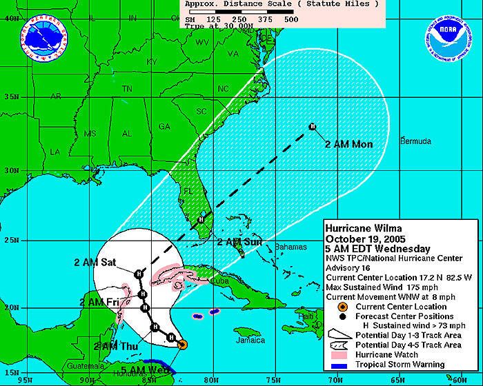
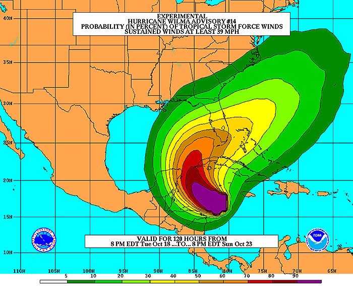
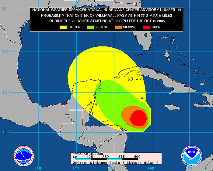
MIAMI, 2005 Oct 19 (From AFP) - Hurricane Wilma intensified into an "extremely dangerous category five hurricane" early Wednesday, churning northward between western Cuba and Mexico's Yucatan peninsula, the US National Hurricane Center said. Wilma, the record-equalling 21st storm of the Atlantic season, strengthened to the highest level on the SaffirSimpson scale, the Miami-based center said in a bulletin at 0630 GMT. "Data from a reconnaissance aircraft indicate that Hurricane Wilma has become an extremely dangerous category five hurricane," the center said half an hour after it had announced the storm had strengthened to category four. Winds at the center of the storm were clocked at 281 kilometers per hour, the center said, adding that the pressure, 892 millibars, was the lowest observed in 2005, and the lower the pressure, the stronger the storm. The hurricane was located 270 kilometers south-southwest of Grand Cayman Islands and 640 kilometers southeast of Cozumel, Mexico, and moving slowly west-northwest toward Mexico's Yucatan peninsula, but was expected to turn toward the northwest within 24 hours. Wilma is expected to move into the Gulf of Mexico, then veer northeast toward Florida. "All interests in the Florida Keys the southernmost US islands, and the Florida peninsula should closely monitor the progress of Wilma," the hurricane center said. World oil prices dropped amid hopes that Wilma would not hit oil installations on the storm-weary US Gulf Coast. Authorities in Cuba, Jamaica, Mexico, Nicaragua and the Cayman Islands have all issued hurricane alerts. Cuba has ordered 5,000 people evacuated from flood-prone areas on the storm's course, and Mexico put the tourist zones of Yucatan on alert. Honduras also ordered preparations for evacuations as heavy rain started falling. Widespread flooding was reported in Jamaica from rainfall sparked by the hurricane.
MIAMI, 2005 Oct 19 (From AFP) - Hurricane Wilma has strengthened into an "extremely dangerous" Category 5 hurricane, with sustained maximum winds of 175 mph, the National Hurricane Center said Wednesday. The hurricane's minimum pressure is 892 millibars the lowest pressure observed in 2005. Forecasters warn that the storm could possibly slam into southwestern Florida by this weekend. At 2:30 a.m. EDT, the National Hurricane Center reported an Air Force plane had found 175 mph winds with higher gusts in Wilma. Wilma "has become an extremely dangerous Category Five hurricane on the Saffir-Simpson scale," the center said in an advisory. The storm's minimum pressure of 892 millibars "is equivalent to the minimum pressure of the 1935 Labor Day hurricane in the Florida Keys," the advisory added. The latest in a slew of devastating storms to sock the Gulf region, Wilma became a hurricane Tuesday tying the record for both most hurricanes in a season with 12 and most named storms at 21. Just nine hours after becoming a hurricane, Wilma's wind speeds had jumped from 75 mph to 100 mph. Then, within two hours, the winds intensified from 110 to 150 mph. A short time later, its winds had increased to 175 mph. At 2 a.m. EDT, the center of the storm was located 170 miles south-southwest of Grand Cayman Island and about 400 miles southeast of Cozumel, Mexico. It was moving west-northwest at nearly 8 mph and is expected to turn to the northwest over the next 24 hours, the hurricane center said. A Category 5 hurricane can cause a storm surge of more than 18 feet above normal. Projections for Wilma's path suggest the storm may skirt the western tip of Cuba on Friday, possibly as a Category 4 storm with winds of greater than 130 mph, before curving eastward and barreling toward the southwestern Florida coast. "All interests in the Florida Keys and the Florida peninsula should closely monitor the progress of Wilma," the NHC said. Hurricane-force winds extend outward about 15 miles from the eye, and tropical-storm-force winds stretch up to 155 miles from the center. Cuba has issued a hurricane watch for the provinces of Matanzas westward through Pinar del Rio and for the Isle of Youth, according to the hurricane center. Late Tuesday, Mexico extended a hurricane watch for the Yucatan Peninsula. The watch area now stretches from Punta Gruesa to Cabo Catoche. A hurricane watch means hurricane conditions, including winds of at least 74 mph, are possible within 36 hours.
A 150-mile stretch of the Honduran coast is under a tropical storm warning, and the Cayman Islands are under tropical storm warning and a hurricane watch. The hurricane center said Cuba could get anywhere from 10 to 15 inches of rain in Wilma's wake, with some areas getting socked with as much as 25 inches. Additional rainfall accumulations of of up to 10 inches, with up to 15 inches possible in some areas, was possible across the Cayman Islands and Jamaica through Thursday. Across the Yucatan Peninsula, rainfall of up to 6 inches was possible, with up to 12 inches in some areas.
Wilma is the 21st named storm of the 2005 hurricane season and the 12th to reach hurricane status. Of those, five have developed into major hurricanes. The only other time 12 hurricanes have been recorded in the Atlantic was in 1969, according to the hurricane center. The most major hurricanes in a year was eight, in 1950. Wilma is also the final name on the 2005 list. The hurricane center does not use certain letters of the alphabet, including X, Y and Z, because there are so few names begin with those letters. If any tropical storms and subsequent hurricanes form before the season ends on Nov. 30, they will be classified using the Greek alphabet, beginning with Alpha. If that happens, it would be the first time since the naming of storms began in 1953, according to the hurricane center.
|
Envisat views of Hurricane Wilma |
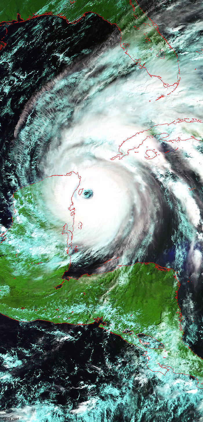
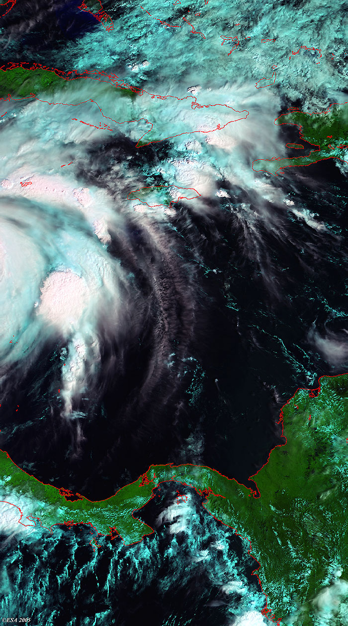
This Medium Resolution Imaging Spectrometer (MERIS) image was acquired over the coast of Yucatan, and shows Hurricane Wilma during its evolution (centre image). The image shows low clouds in blue and both high and low clouds in white. The coastlines have been highlighted in red to define their locations.
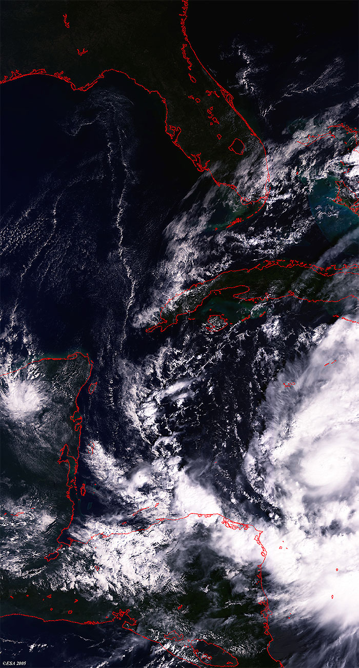
This Medium Resolution Imaging Spectrometer (MERIS) image was acquired over the southern coast of Yucatan, and shows Hurricane Wilma during its evolution (centre left image). The image shows low clouds in blue and both high and low clouds in white. The coastlines have been highlighted in red to define their locations.
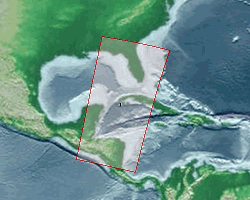
This Medium Resolution Imaging Spectrometer (MERIS) Level 1 image was acquired on 18 October 2005 over the Caribbean Sea and shows Hurricane Wilma (centre lower right image), along the coasts of Honduras and Cuba. The coastlines have been highlighted in red to define their locations.
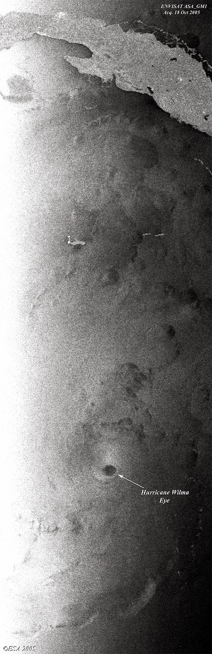
This ASA_GMM image was acquired on 18 October 2005 over the Caribbean Sea and shows Hurricane Wilma (centre lower image), south of Cuba.
Back to top
 Hurricane Wilma (Caribbean Sea) - October 2005