MIAMI, Sept 20 (From AFP) - Rita strengthened into a hurricane Tuesday as it barreled toward southernmost Florida and the Gulf of Mexico on a track that could eventually take it dangerously close to devastated New Orleans. Data collected by a hurricane hunter aircraft showed that Rita gathered strength as it swirled off the Atlantic coast of Cuba, reaching sustained winds of at least 119 kilometers per hour, according to the National Hurricane Center. Rita, which until then was a tropical storm, was likely to gather more steam as it moves over warmer waters, and could reach category three on the five-level Saffir-Simpson hurricane intensity scale, the Miami-based NHC said. Its projected track would take just over or close to the vulnerable city of Key West at the southern tip of the Florida Keys chain of islands linked to the mainland by a series of bridges and a single road. Other areas of south Florida, including Miami were also likely to feel the impact of the hurricane. Bands of wind and rain propelled by the storm already impacted the threatened areas Tuesday morning, knocking out power to almost 11,000 homes.In Key West, usually a bustling tourist destination, residents who had not yet evacuated were urged to stay indoors as roads were becoming increasingly hazardous.
MIAMI, Sept 20 (From AFP) - A mass exodus from the deadly threat of Hurricane Rita emptied towns along the Texas and Louisiana coastlines Friday, amid frantic last-minute preparations for the second super-storm in a month. With Rita expected to hit the Gulf Coast late Friday, more than one million people piled into cars and buses with whatever they could carry, creating monumental traffic jams on all roads heading inland. The port city of Galveston, scene of the worst US natural disaster when a similar storm hit 105 years ago, was virtually empty early Friday. Only the most hardy survivors from the devastation of Hurricane Katrina on August 29 stayed in New Orleans. Residents also fled most other cities and towns on a 500 kilometer stretch of coast from Port O'Connor in Texas to Morgan City in Louisiana, which is under a formal hurricane warning. The storm claimed its first victim before it even hit land when an elderly woman died of apparent heat exhaustion while stuck in a massive traffic jam of Texas evacuees.
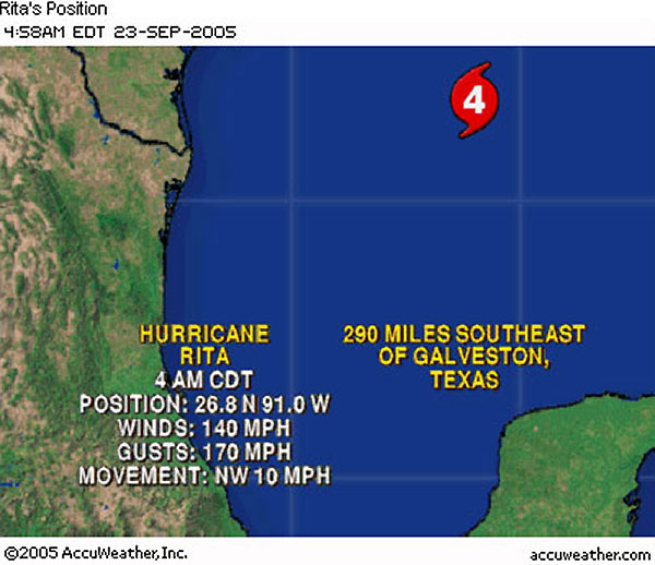
Texas, 2005 September 23 (From CNN) - A weakened but still powerful Hurricane Rita continued its march today toward the Texas-Louisiana coast, with forecasters saying the Category 4 storm could possibly strengthen before making landfall early Saturday. Some areas of the two states are already experiencing Rita's outer bands.
|
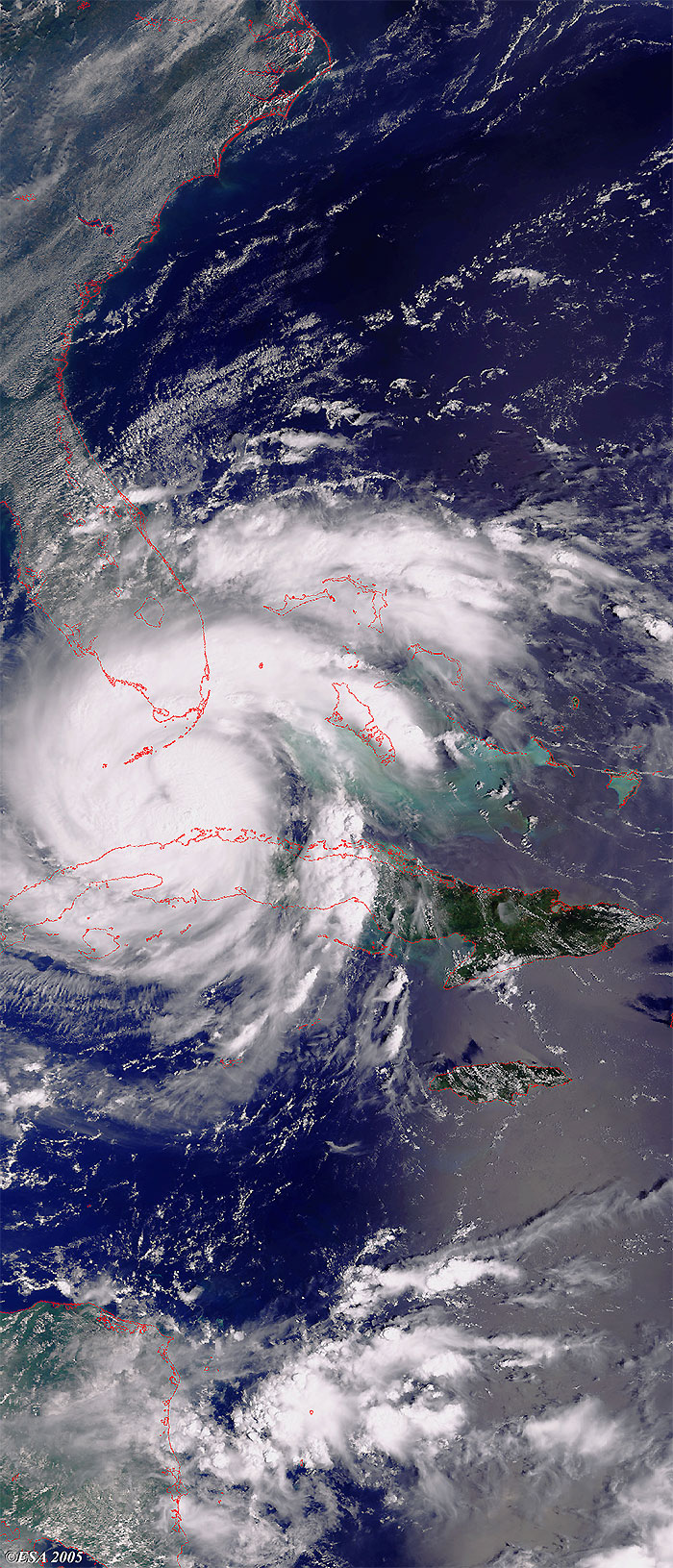
Envisat views of Hurricane Rita |
This Medium Resolution Imaging Spectrometer (MERIS) Level 1 image was acquired over the coast of Florida, and shows Hurricane Rita during its evolution. The coastlines have been highlighted in red to define their locations.
This Advanced Synthetic Aperture Radar (ASAR) image presents an alternate view of Hurricane Rita as it moved into the Gulf of Mexico off the coast of Cuba.
Also available is a version of the image without the location reference points.
This image presents a magnified view of the eye of the hurricane.
This Medium Resolution Imaging Spectrometer (MERIS) Level 1 image was acquired on 22 September 2005 over Hurricane Rita during its evolution along the coasts of the Gulf of Mexico. The coastlines have been highlighted in red to define their locations.
This Medium Resolution Imaging Spectrometer (MERIS) Level 1 image is the latest acquisition over Hurricane Rita during its evolution along the coast of Texas. The coastlines have been highlighted in red to define their locations.
Back to top
 Hurricane Rita (Florida) - September 2005


