 Browse SAR Events by Year
20 Years of SAR
Browse SAR Events by Year
20 Years of SAR
Results: 160
Typhoon Durian (Philippines) - December 2006It is estimated that a thousand people died in the Philippines when Typhoon Durian struck in November and December 2006. Tends of thousands of people were affected by the damage to houses and infrastructure as well as mudslides caused by heavy rain. 
Philippines, August 2006Sludge has washed up on Panay, a large island in the central Philippines, as an oil spill from a sunken tanker spread, threatening rich fishing grounds. Eleven days after the tanker chartered by Petron Corp., the largest oil refiner in the Philippines, sunk off the island of Guimaras, an average of 100-200 litres of oil continued to gush every hour. 
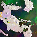
Mount Merapi Volcano - Indonesia, June 2006Merapi, (Island of Java), which is located near the ancient royal city of Yogyakarta (Indonesia), is considered to be one of the most dangerous volcanoes in the Pacific “Ring of Fire”. It has threatened a major eruption over the weeks, forcing evacuations of 18,000 people from its slopes. 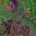
Brazil deforestation - August 2006These two Envisat images examine an area of deforestation in the Mato Grosso region of Brazil, utilising multi-layer compositions to track changes over time. 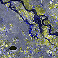
Flood - Elbe River (Germany), April 2006The water level of the Elbe River rose to 150-year records in April 2006, leading to flooding in the town of Hitzacker where the water level rose to almost 8 metres. Many buildings were destroyed and the inundation caused widespread damage. 
B-15A iceberg monitoring - Antarctica (2004-2006)This series of Envisat images monitor iceberg B-15A from November 2004 to February 2006. B-15A was a fragment of the largest iceberg in recorded history and broke apart during 2005. 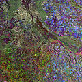
Kiev, Ukraine - 2005This ERS-2 image was acquired on 5 December 2005 over Kiev in Ukraine. 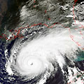
Hurricane Rita (Florida) - September 2005120 people died in the United States of America in September 2005 when Hurricane Rita made landfall in the southeastern states. Severe damage from the winds and subsequent flooding affected thousands of people and destroyed several small communities. 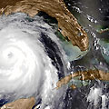
Hurricane Katrina (Florida) - August 2005Hurricane Katrina was one of the worst storms to strike the United States in recorded history when it made landfall in the Gulf coast in August 2005. 1833 people died and the city of New Orleans was particularly affected, with 80% of the city inundated leading to years of recovery. 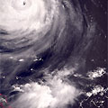
Typhoon Talim (Central Pacific Ocean) - August 2005It was estimated that over 15 million people were affected by Typhoon Matsa during August 2005 in Taiwan and China. 150 people were killed and thousands of homes destroyed by flooding and landslides. 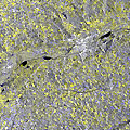
Flood - Europe, August 2005The state of Bavaria, in Germany, was one of the many places affected by the 2005 flooding in Europe. The River Danube burst its banks and caused widespread flooding in August. 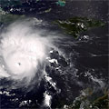
Hurricane Emily (Mexico) - July 2005Hurricane Emily caused widespread damage in the Caribbean and northeastern Mexico in July 2005. 17 people were killed and hundreds of homes were destroyed or damaged by the hurricane's powerful winds and storm surges. Thousands of people were affected. 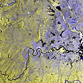
Flood - China (Jiangxi), July 2005A dike burst in the Fu River in Jiangxi Province, China, following heavy rain across ten Chinese provinces in June 2005. 35,000 people were evacuated in Jiangxi Province, and the widespread flooding in China claimed 200 lives. 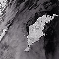
Gotland Island (Sweden), May 2005A 97-kilometer (60-mile) oil slick was observed off Sweden's south-eastern coast near the Baltic Sea island of Gotland. The approximately 25 tonnes of oil were however not expected to cause any major environmental damage as low winds and currents were predicted for the next two days. 
ERS-2 - Ten years in orbit (1995-2005)The ERS-2 satellite was launched on 21 April 1995, as a successor to the ERS-1 satellite. ERS-2 has now been successfully operational for ten years, and the following features highlight some of the applications the mission has been utilised for, as well as some technical details of the satellite. 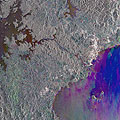
Panama Canal, Panama - 2005This ERS-2 image was acquired on 14 April 2005 over the Panama Canal. 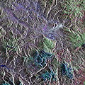
Sarajevo, Bosnia and Herzegovina - 2005This ERS-2 image was acquired on 10 April 2005 over Sarajevo in Bosnia & Herzegovina. 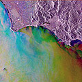
Gaeta, Italy 2005This ERS-2 image acquired over Gaeta on the West coast of Italy was acquired on 31 March 2005 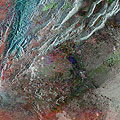
Damascus, Syria - 2005This ERS-2 image was acquired on 4 January 2005 over Damascus in Syria. 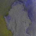
Earthquake/Tsunami - Sri Lanka, Thailand and India, 26 December 2004A collection of Envisat MERIS/ASAR Full Resolution images acquired during the Earthquake/Tsunami event in Sri Lanka, Thailand and India. |
||