 Browse SAR Events by Year
20 Years of SAR
Browse SAR Events by Year
20 Years of SAR
Results: 160
The Envisat Mission: 10 years of operationLaunched on 01 March 2002, Envisat has completed ten years of operations. During its operational life, Envisat has played a major role in the progresses made in Earth System Science, as well as on the creation of operational monitoring services, paving the way for future Earth Observation missions. This series of images features views of the world acquired by Envisat over its ten years of operation. 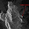
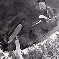
Giglio Island, Italy (Cruise ship accident) - January 2012This series of Envisat radar images examine Giglio Island, where the Costa Concordia cruise ship ran aground on 13 January 2012. 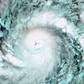
Hurricane Season 2011This series of Envisat MERIS and ASAR images look at some of the Atlantic hurricanes that were a part of 2011's Hurricane Season. 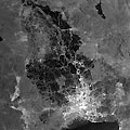
Flood - Thailand, October 2011The 2011 monsoon season caused flooding in Thailand that lasted from July 2011 to January 2012 following Tropical Storm Nock-ten. 815 people died in the disaster and over 13 million were affected. The flooding affected almost the entirety of Thailand to some degree. 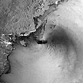
Typhoon Nesat (Philippines, Vietnam, China) - September 2011Typhoon Nesat affected the Philippines, China and Vietnam during September 2011 leaving almost 100 people dead. The majority of the casualties were in the Philippines, but all three countries suffered flooding and damage from the storm. 
Hurricane Irene - August 2011Hurricane Irene caused over 50 deaths in the eastern United States and Caribbean islands during August 2011. The storm caused a great deal of damage, leading to a costly recovery. 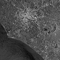
Celebrating 20 years of ERSThese images of Rome and its surroundings were acquired by ERS-1 and ERS-2 during their long service around the globe, providing valuable information to the scientific community for 20 years. 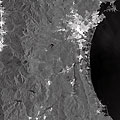
Earthquake/Tsunami - Japan, March 2011Japan was struck by the worst earthquake in its recorded history on 11 March 2011. The category 9 earthquake left 15,883 people dead and affected millions across Japan. It also caused a tsunami which lead to further damage and flooding. Hundreds of thousands of homes were either destroyed or suffered damage and a full recovery from the damage would take years. 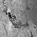
Flood - Australia, January 2011Over 200,000 people were affected by flooding in Queensland, Australia, during December 2010 and January 2011. 38 people died and thousands of homes were inundated by floodwaters. 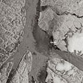
Petermann Glacier, GreenlandThese Envisat images, acquired by the ASAR and MERIS instruments, show the progression of the giant iceberg calved along the Nares Strait from the Petermann glacier in northern Greenland, one of the largest of the country's glaciers. 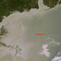
Gulf of Mexico, April - May 2010The plan to start choking off oil gushing into the Gulf of Mexico was suddenly halted as government officials and BP said further analysis must be done Wednesday before critical tests could proceed. No explanation was given for the decision, and no date was set for when testing would begin on the new, tighter-fitting cap BP installed on the blown-out well Monday. In the meantime, oil continued spewing into the Gulf. 
Earthquake - Italy, April 2009A 5.8/5.9 magnitude earthquake struck L'Aquila, Italy on 06 April 2009. 297 people were killed and over 60,000 left homeless as houses were damaged or destroyed. 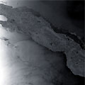
Hurricane Paloma (Cuba) - November 2008Hurricane Paloma forced thousands of people to evacuate in Cuba during November 2008. The powerful storm destroyed over 8000 homes on the island as its strong winds tore wooden homes apart. Despite the severe damage, no deaths were reported as a result of the storm. 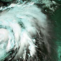
Typhoon Sinlaku (Taiwan) - September 2008Typhoon Sinlaku brought heavy rain to Taiwan in early September 2008. The storm caused flooding that forced a thousand people to evacuate and left 12 dead. 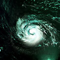
Hurricane Ike (Atlantic Ocean), September 2008Hurricane Ike was a large storm that affected Haiti, Cuba and several U.S. states along the Gulf of Mexico in September 2008. Almost 200 people died during the storm and millions were affected by it. 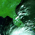
Hurricane Gustav (Caribbean Sea) - September 2008Hurricane Gustav affected several countries in the Caribbean Sea during August and September 2008. Approximately 150 people were killed and many areas suffered damage from landslides and flooding. 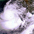
Cyclone Nargis (Myanmar) - May 2008Cyclone Nargis struck Myanmar in April and May 2008. It was the worst disaster in Myanmar's recorded history, killing an estimated 150,000 people and destroying thousands of homes and affecting approximately 2 to 3 million people. 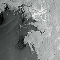
South Korea, December 2007South Korea's worst ever oil spill spread along a pristine coastal region Monday as the government came under fire amid charges it acted too slowly to limit the disaster. Almost 9,000 troops, police and volunteers armed with shovels and buckets struggled to clean up the huge slick. 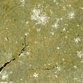
Flood - United Kingdom, July 2007Following one of the wettest months in Britain's weather records, the UK and Northern Ireland suffered a series of floods between June and July 2007. 13 people were killed and much of the country was affected. 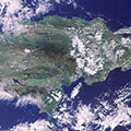
Envisat - 25,000 orbits - December 2006The Envisat satellite, launched in 2002 recently achieved 25,000 orbits. To celebrate the satellite circling our world a quarter of a million times, these two images feature views acquired on that 25,000th orbit. |
||