- All Categories (13600)
- Data (1)
- News (23)
- Missions (13)
- Events (11)
- Activities (7)
- Campaigns (2)
- Documents (13543)
NEWS
Discover the latest news on the European Space Agency's Earth Observation activities. Learn all about new data availability and how ESA's missions are performing.
News - Success Stories
 24 Nov 2021
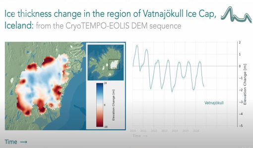
CryoTEMPO-EOLIS Products Now Available for Iceland, Svalbard, and the Canadian Arctic
Land-ice monitoring via Earth Observation methods in general, and altimetry in particular, are essential for tracking the current
News - Events and Proceedings
1 June 2023GLOC 2023: Democratising data access key to climate action
Currently, more than a trillion tonnes of ice is lost each year.
News - Thematic area articles
 29 Sept 2022
How satellite data help to shape society
Title: Current drought situation in Ebro basin Description: The SMOS soil-moisture-based drought monitor is updated monthly
News - General News
21 Mar 2023ESA's excellent Earth Explorer missions extended to 2025
Acting like the spinning conductor in a bicycle dynamo, it generates electrical currents and thus the continuously changing
News - Operational News
 12 Jan 2024
Delay in the availability of CryoSat Products
There is currently an ongoing technical issue at the CryoSat Payload Data Ground Segment (PDGS).
News - Data Release news
 14 Apr 2023
Back-processed data from 2010 now available for CryoTEMPO-EOLIS Baseline 2
Arctic Canada North High Mountain Asia (Central/South East/South West Asia) Russian Arctic Svalbard Iceland Regions that are currently
News - Data Release news
 22 July 2021
New reprocessing of datasets celebrates 30 years of ERS
For each surface, the experts will use our current knowledge acquired over 30 years of experience, to improve the ERS altimetric
News - Thematic area articles
 31 Mar 2022
Satellite data central to ocean monitoring
microwave monitoring instruments, optical imagers, and infrared radiometers, which can map ocean variables related to ocean currents
News - Success Stories
 25 Nov 2021
COP26 fuels interest in satellite data
operational and non-operational ESA missions provide long-term Earth observational records, giving essential context to current
News - Infographics
12 Mar 2024Showcasing success stories from ESA's Heritage Missions
success stories showcased used data from ESA's ERS (European Remote Sensing) and Envisat satellites in combination with current
News - Data Release news
 23 Mar 2023
New CryoSat Ice Baseline-E 2012 and 2013 Reprocessed Data – Available now!
The Ice Baseline-E Reprocessing campaign is currently underway to reprocess all CryoSat ice products from July 2010 - August
News - Data Release news
 5 May 2023
New CryoSat Ice Baseline-E 2016 and 2017 Reprocessed Data – Available now!
The Ice Baseline-E Reprocessing campaign is currently underway to reprocess all CryoSat ice products from July 2010 - August
News - Data Release news
 13 Apr 2023
New CryoSat Ice Baseline-E 2014 and 2015 reprocessed data – Available now!
The Ice Baseline-E Reprocessing campaign is currently underway to reprocess all CryoSat ice products from July 2010 - August
News - Success Stories
 19 May 2022
New one-stop-shop for ESA and NASA altimetry data
Currently, the available standard combined products are: SAR Sea Ice (IS2 ATL07 vs CS2 SAR mode L2) – available for Arctic
News - Success Stories
 21 Dec 2021
Retrieving Snow Depth Over Sea Ice Using Dual-Frequency Altimetric Measurements
the launch of SARAL in 2013, have been shown to provide a better climatological solution than the snow depth climatology currently
News - Data Release news
 27 Jan 2022
New CryoSat-2 Thematic Products Now Available
The current product release represents the culmination of Phase 1 of the Cryo-TEMPO activities, which began in October 2020
News - Data Release news
 20 Oct 2020
Systematic swath elevation and monthly DEMs over the Antarctica Ice Sheet margin from CryoSat 2
Land-ice monitoring via Earth Observation methods in general, and altimetry in particular, are essential for tracking the current
News - Success Stories
 27 Sept 2022
Heritage data trains neural networks to detect urban sprawl
Since they’ve been trained identically, they can help monitor both current and past urban changes.
News - Success Stories
7 Feb 2024Trailblazing ERS-2 mission enables climate change applications
Varied elevations of Bachu in western China InSAR is currently one of the most accurate methods to generate digital elevation
News - Success Stories
31 Aug 2023New CryoSat data to boost understanding of the oceans
The dataset – presented in the Nature Research journal Scientific Data and currently available for download – provides a