- Learn & Discover
- New one-stop-shop for ESA and ...
New one-stop-shop for ESA and NASA altimetry data
19 May 2022
cs2eo.org is a free, easy-to-use portal to explore, combine and download airborne and spaceborne altimetry data from CryoSat-2, ICESat-2, CryoVEx, IceBridge and CryoTEMPO-EOLIS.
Building on the successful CryoSat-2/ICEsat-2 (CRYO2ICE) coincident data explorer, cs2eo.org contains a number of new features and datasets.
“The new cs2eo website is an all-in-one resource for anyone working with CryoSat-related data,” says CryoSat Mission Manager Tommaso Parrinello. “It should now be easier and quicker than ever to work with combined CryoSat and ICESat altimetry data.”
An easily-navigable, user-friendly interface containing a wealth of examples and easy-to-use starter queries brings together three services:
- Cryo2Ice.org
- CryoVEx.org
- CryoTEMPO.org
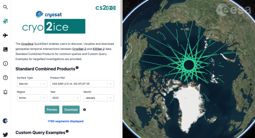
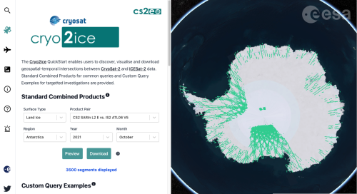
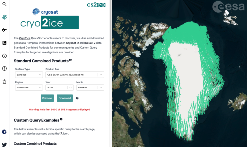
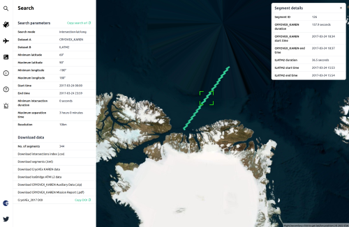
Cryo2Ice.org - download combined CryoSat-2/ICESat-2 data
Since July 2020, ESA's CryoSat-2 and NASA's ICESat-2 have periodically aligned as part of the CRYO2ICE campaign. This provides radar and lidar measurements of the same ice, at nearly the same time, helping to improve estimates of snow depth and ice thickness over land and sea.
Cryo2Ice.org was developed to allow users to easily find these near-coincident measurements, and cs2eo.org delivers useful new features.
Users can now perform on-demand filtering and combining of data. This key new feature combines CryoSat-2 and ICESat-2 intersecting data into the same NetCDF files, saving users the trouble of filtering down the original files and combining the data themselves, and reducing the amount of data to download.
Commonly used queries are precomputed and stored monthly in the form of standard combined products, which are immediately available and fast to download.
Currently, the available standard combined products are:
- SAR Sea Ice (IS2 ATL07 vs CS2 SAR mode L2) – available for Arctic and Antarctic
- SARIn Land Ice (IS2 ATL06 vs. CS2 SARIn mode L2) - available for 10 regions
- LRM Land Ice (IS2 ATL06 vs. CS2 LRM mode L2) – available for Greenland and Antarctica
Predicted ground track data is also available, allowing users to view and plan for future CryoSat-2 and ICESat-2 satellite passes and intersections.
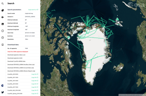
CryoVEx.org - easy access to CryoSat validation data
The CryoSat Validation Experiment (CryoVEx) is a series of airborne and ground collection campaigns designed to generate validation data for CryoSat-2 and other ESA missions.
cs2eo.org users can query and download analysis-ready airborne datasets or intersect them with CryoSat-2, IceSat-2 and NASA’s Operation IceBridge data, and a rich set of example queries are available.
All the files originally in a format other than NetCDF have been converted to NetCDF to be analysis-ready, while keeping the structure of files consistent with the campaign handbooks.
Currently the following sensors are available for the CryoVEx missions between 2010 and 2018: ALS (laser), ASIRAS (Ku band radar), KAREN (Ka band radar) and AEM (airborne ice thickness).
Future releases will include the new dual-band CReSIS radar, 2019 campaigns and photographic datasets.
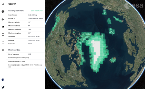
CryoTEMPO.org - access CryoTEMPO-EOLIS point and gridded products
Land-ice monitoring by altimetry is essential for tracking the current status of ice volume change and its evolution.
In this context, ESA launched the CryoSat ThEMatic PrOducts (Cryo-TEMPO) activity that supports a wide variety of end-users working in the areas of sea ice, polar oceans, land ice, coastal areas and hydrology.
The CryoTEMPO-EOLIS (Elevation Over Land Ice from Swath), is now live over the Greenland and Antarctic ice sheets, and all remaining glaciers worldwide. The EOLIS products exploit CryoSat’s SARIn mode and the novel Swath processing technique to deliver increased spatial and temporal coverage of time-dependent elevation over land ice, a critical metric for tracking ice mass trends.
More features soon to be added
“This platform is intended to be as user-friendly and useful as possible, and we will further develop the website in the coming months,” says Martin Ewart, CEO and co-founder of Earthwave.
“We are continuously improving the service and would appreciate feedback for any datasets, additional features and functionality you would like added to the user interface."
cs2eo.org was built by Earthwave and the University of Edinburgh School of Geosciences as part of ESA’s CryoTEMPO programme. Any feedback, suggestions or questions should be sent to support@cs2eo.org.
For more detailed information on how to use the portal, you can access the user guide.