- All Categories (289)
- Data (4)
- News (35)
- Missions (3)
- Events (13)
- Tools (9)
- Activities (7)
- Documents (218)
NEWS
Discover the latest news on the European Space Agency's Earth Observation activities. Learn all about new data availability and how ESA's missions are performing.
News - Announcement of Opportunity updates
 18 Mar 2024
Announcement of Opportunity for SAOCOM – deadline extended
The submission deadline for the ESA/CONAE Announcement of Opportunity for SAOCOM mission data has been extended until 31 December 2024.
News - Success Stories
14 Mar 2024How scientists are unlocking the potential of SAOCOM
A team of scientists has drawn on SAOCOM data to measure the heights of forests in Argentina, marking the first time that tree canopies have been mapped using the two-satellite constellation.
News - General News
4 Oct 2023PROBA-V’s companion explores low-cost remote sensing
With the launch of PROBA-V’s Companion CubeSat (PV-CC), ESA supports a future where clusters of cheaper, small satellites could complement full-scale missions for Earth observation.
News - Spotlight on EO community
30 June 2023Meet the Quality Assurance for EO Team
The Quality Assurance For Earth Observation (also known as QA4EO) Service began its operations on 1 November 2019, providing support to the Data Quality and Algorithms Management Office at ESRIN, within the Sensor Performance, Processing and Algorithm section.
News - Spotlight on EO community
13 June 2023Meet one of ESA's first Africa Programme Research Fellows
Research Fellow, Dr Gladys Mosomtai, from the International Centre of Insect Physiology and Ecology (icipe), works on applying Earth observation data to better understand the spread of infectious disease in livestock, in Kenya.
News - Success Stories
8 May 2023PROBA-V data improve surface albedo products in Africa
As ESA’s PROBA-V satellite marks its 10-year launch milestone, data tasked during the mission’s lifetime are still being used to assess changes in land cover.
News - Data Release news
11 Apr 2023PROBA-V ‘Collection 2’ - Reprocessed Dataset available
The improved PROBA-V data (Collection 2) has been released. Data is available via the PROBA-V MEP and Terrascope platforms so users can freely exploit the data using Virtual machines, Jupyter Notebooks, and the new viewing application.
News - Announcement of Opportunity updates
14 Mar 2023Researchers called to explore new applications of SAOCOM data
ESA has invited Earth observation experts to devise and propose innovative applications for data delivered by Argentinian remote sensing constellation SAOCOM.
News - Thematic area articles
3 Mar 2023Monitoring water on Earth's surface
ESA's Earth observation satellites are playing a leading role in furthering our understanding of how Earth's terrestrial hydrosphere is being influenced by humankind.
News - General News
16 Feb 2023International collaboration: Summarising ESA’s Third Party Missions
ESA’s Third Party Missions programme consists of more than 50 missions from around the world. Learn more about the Third Party Missions in this video.
News - Success Stories
30 Jan 2023Showcasing success stories from ESA's Third Party Missions
ESA’s Third Party Missions programme consists of more than 50 missions from around the world.
News - Thematic area articles
9 Dec 2022Global understanding of Earth's land surfaces greatly boosted by satellite data
ESA perform land surface monitoring with a range of instruments onboard satellites acquiring optical and radar data. Collections of data from these missions are freely available for research purposes.
News - Thematic area articles
 2 Nov 2022
Satellites investigate Earth’s terrestrial hydrosphere
ESA’s Earth observation satellites are playing a leading role in furthering our understanding of how Earth’s water cycle is being influenced by humankind.
News - Success Stories
 26 July 2022
SAR synergy data for maritime surveillance
With the aim of safeguarding our oceans, a recent study uses a synergy of synthetic aperture radar (SAR) images to improve maritime surveillance.
News - General News
14 July 2022Campaign using surface reflectance data to support validation of Earth observation products
Scientists from around the world are set to take part in a drone monitoring campaign and inter-comparison exercise that will deliver surface reflectance data to support the validation of Earth observation products.
News - Thematic area articles
 31 Mar 2022
Satellite data central to ocean monitoring
Over 95% of Earth’s water is found in our oceans, and yet sadly, oceans are under stress from climate change and pollution. Monitoring our oceans is vital for Earth’s survival and satellites are the primary means of long-term and independent observation of our vast ocean bodies and their associated coastal zones.
News - Success Stories
 11 Feb 2022
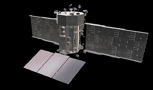
SAOCOM the Argentinean constellation with an Italian twist
Composed of two satellites launched in 2018 and 2019 respectively, the SAOCOM satellite mission, managed and operated by Argentina's Space Agency, CONAE, covers an array of applications that greatly benefit Earth observation and disaster monitoring.
News - Infographics
 7 Feb 2022
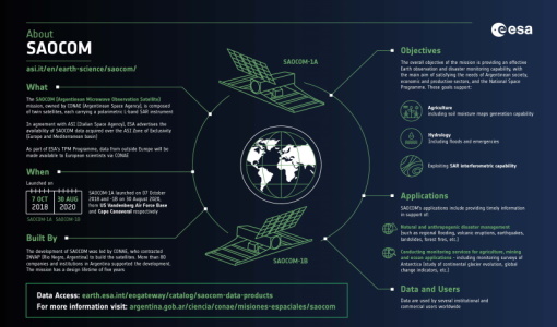
An overview of the SAOCOM SAR satellite missions
Learn more about the SAOCOM mission, a constellation of two satellites, in our latest infographic.
News - Thematic area articles
 2 Feb 2022
Satellite data boost global understanding of land surface
Understanding our changing land surface is essential in the study of climate change. Satellites are used to monitor changes to the material that covers Earth’s surface, so-called land cover, such as vegetation and water.
News - Success Stories
 13 Dec 2021
Ship trails in the Bay of Biscay observed using PROBA-V imagery
Ship trails have been perceived as convincing evidence of aerosol-cloud interaction. Ship emissions have been proven to contribute by about 1.9% and 2.9% to the increase in the global total and fine-mode aerosol optical thickness (AOT) respectively over a five year period (Peters et al. 20212).