- All Categories (23364)
- News (32)
- Missions (1)
- Events (4)
- Tools (3)
- Activities (1)
- Documents (23323)
NEWS
Discover the latest news on the European Space Agency's Earth Observation activities. Learn all about new data availability and how ESA's missions are performing.
News - Data Release news
 13 May 2022
Updated CryoSat magnetometer data now available with new baseline 0201
An improved version of the CryoSat magnetic field data is now available on the Swarm Dissemination Server with new baseline 0201.
News - Thematic area articles
 30 June 2022
Transforming space data into climate action
ESA’s Earth observation activities are playing a key role in the revitalised global drive to combat climate change.
News - Data Release news
 20 Oct 2020
Systematic swath elevation and monthly DEMs over the Antarctica Ice Sheet margin from CryoSat 2
Land-ice is declining globally, raising sea levels worldwide and impacting glacial risks and access to fresh-water in high-mountain glaciers regions.
News - Thematic area articles
 31 Mar 2022
Satellite data central to ocean monitoring
Over 95% of Earth’s water is found in our oceans, and yet sadly, oceans are under stress from climate change and pollution. Monitoring our oceans is vital for Earth’s survival and satellites are the primary means of long-term and independent observation of our vast ocean bodies and their associated coastal zones.
News - Success Stories
 22 Nov 2022
Robust airborne radar instrument aids CryoSat ice data
During the 12 years that ESA’s ice mission – CryoSat – has been monitoring Earth’s ice masses from space, simultaneous airborne measurements were made by ASIRAS.
News - Success Stories
 21 Dec 2021
Retrieving Snow Depth Over Sea Ice Using Dual-Frequency Altimetric Measurements
A new study from the sea ice team of the Laboratory of Space Geophysical and Oceanographic Studies (LEGOS) in Toulouse has shown that dual-frequency SARAL and CryoSat-2 altimetric measurements can be used to retrieve consistent snow depth data over sea ice in both hemispheres.
News - Success Stories
 19 May 2022
New one-stop-shop for ESA and NASA altimetry data
cs2eo.org is a free, easy-to-use portal to explore, combine and download airborne and spaceborne altimetry data from CryoSat-2, ICESat-2, CryoVEx, IceBridge and CryoTEMPO-EOLIS.
News - Data Release news
28 Mar 2023New CryoTEMPO-EOLIS baseline 2 point and gridded products
New CryoTEMPO EOLIS baseline 2 point and gridded products are now available monthly as of January 2023.
News - Data Release news
 16 June 2023
New CryoSat Ice Baseline-E Reprocessed Data – Available now!
The CryoSat Ice Baseline-E Reprocessing campaign is now complete.
News - Data Release news
 5 May 2023
New CryoSat Ice Baseline-E 2016 and 2017 Reprocessed Data – Available now!
We are pleased to inform the CryoSat scientific community that the reprocessed CryoSat Ice Baseline-E data for all of 2016 and 2017 has been published on the Science Server and is now available for download.
News - Data Release news
 13 Apr 2023
New CryoSat Ice Baseline-E 2014 and 2015 reprocessed data – Available now!
The reprocessed CryoSat Ice Baseline-E data for all of 2014 and 2015 has now been published on the Science Server.
News - Data Release news
 23 Mar 2023
New CryoSat Ice Baseline-E 2012 and 2013 Reprocessed Data – Available now!
We are pleased to inform the CryoSat scientific community that the reprocessed CryoSat Ice Baseline-E data for all of 2012 and 2013 has been published on the Science Server and is now available for download.
News - Success Stories
31 Aug 2023New CryoSat data to boost understanding of the oceans
A new CryoSat sea level anomaly product designed to enable ocean science and the development of operational marine applications has been released.
News - Data Release news
 16 Mar 2023
Near-Real Time Full Bit Rate (FBR) CryoSat products now available
We’re pleased to announce that as of 15 March 2023, the CryoSat Full Bit Rate (FBR) products are disseminated in Near-Real Time (NRT).
News - Success Stories
 13 May 2019
ESA's Earth Explorers surpassing expectations
In this video, learn how each Earth Explorer mission is contributing to Earth science, and changing the way we look at our beloved planet.
News - Success Stories
29 June 2023ESA missions help to reveal worldwide lake water loss trend
Climate change, human consumption and sedimentation are depleting more than half of the world’s biggest lakes of water, according to a ground-breaking analysis that drew on three decades of satellite data.
News - Operational News
 12 Jan 2024
Delay in the availability of CryoSat Products
A technical issue occurred at the CryoSat Payload Data Ground Segment (PDGS).
News - Success Stories
 6 Oct 2022
Decades of satellite data reveal the risks of climate tipping points
Decades-long time series that draw on ESA’s Earth observation archives are enabling scientists to uncover the threat of sudden and potentially irreversible changes to the icy parts of the planet.
News - Success Stories
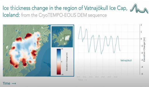 24 Nov 2021
CryoTEMPO-EOLIS Products Now Available for Iceland, Svalbard, and the Canadian Arctic
Land-ice is declining globally, raising sea levels worldwide and impacting glacial risks and access to fresh-water in high-mountain glaciers regions. Land-ice monitoring via Earth Observation methods in general, and altimetry in particular, are essential for tracking the current status of ice volume change and its evolution as climate continues to evolve and mitigating actions are being pursued.
News - Data Release news
 27 May 2021
CryoTEMPO EOLIS and Operation IceBridge Data Added to Cryo2Ice Coincident Data Explorer
CryoTEMPO-EOLIS and Operation IceBridge data are now available in the Cryo2Ice Coincident Data Explorer.