- All Categories (162)
- Data (51)
- News (57)
- Missions (15)
- Events (24)
- Tools (1)
- Activities (6)
- Campaigns (1)
- Documents (7)
NEWS
Discover the latest news on the European Space Agency's Earth Observation activities. Learn all about new data availability and how ESA's missions are performing.
News - Success Stories
 17 May 2022
Vision-1 to enable cutting-edge science and spur innovation
Vision-1 – which is the result of a collaboration between Airbus Defence and Space and Surrey Satellite Technology Ltd. (SSTL) – provides sub-metric imagery to support activities across many industries, including urban planning, agricultural monitoring, land classification, natural resource management and disaster monitoring.
News - Data Release news
 17 May 2022
Vision-1 data now open to users
In the framework of the Third Party Missions programme, ESA is offering, for scientific research and application development, access to archive and new tasking data from the Vision-1 mission upon submission and acceptance of a project proposal.
News - Success Stories
 22 Dec 2020
Using Satellite Data to Predict Floods and Droughts
Scientists are turning to remote sensing to fill the in-situ data gap in hydrological data models in some parts of the world.
News - Infographics
22 Feb 2023Twin satellites - TerraSAR-X and TanDEM-X
DLR's TerraSAR-X and TanDEM-X are twin satellites flying in close formation to acquire SAR data of unique geometric accuracy. Operating together, the missions deliver data that are used to generate Digital Elevation Models of Earth.
News - Success Stories
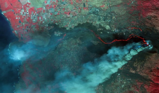
7 Feb 2024Trailblazing ERS-2 mission enables climate change applications
As ESA’s ERS-2 satellite approaches Earth’s atmosphere for reentry, it’s time to reflect on the mission’s great achievements in powering climate-related applications.
News - Infographics
 13 July 2022
The International Charter - Providing satellite data to support disaster response worldwide
Learn about the International Charter Space and Major Disasters in this new infographic.
News - Operational News
 12 Feb 2024
Temporary interruption to Envisat AATSR dissemination service
A planned downtime will affect the access to the ftp dissemination server for the Envisat AATSR data during the period 13-15 February 2024.
News - Data Release news
24 June 2021Static Maps for ALOS African coverage available for users
ALOS Africa is a dataset of the best available (cloud minimal, below 10%) African coverage acquired by AVNIR-2 in OBS mode and PRISM in OB1 mode (all Backward, Nadir and Forward views, in separated products), two different collections one for each instrument.
News - Infographics
21 Feb 2024Showcasing the NovaSAR-1 radar satellite
Learn about the NovaSAR-1 mission in our new infographic.
News - Infographics
12 Mar 2024Showcasing success stories from ESA's Heritage Missions
Find out how ESA's Heritage Space Programme data continue to help, even decades after they finished operations, in our latest infographic.
News - Data Release news
 3 Dec 2021
SAOCOM data collection now open
SAOCOM data products acquired over the ASI Zone of Exclusivity (European territory and Mediterranean) are available to registered users.
News - Announcement of Opportunity updates
 14 Mar 2023
Researchers called to explore new applications of SAOCOM data
ESA has invited Earth observation experts to devise and propose innovative applications for data delivered by Argentinian remote sensing constellation SAOCOM.
News - Thematic area articles
25 Apr 2023Remote sensing data map impacts of natural hazards
As climate change increases the frequency and severity of natural disasters, remote sensing data can warn about extreme events and help tackle emergency situations.
News - Data Release news
 8 Oct 2020
RADARSAT data on demand
In the framework of the Earthnet programme, ESA is distributing RADARSAT data on-demand to support EO science and research activities.
News - Data Release news
11 Apr 2023PROBA-V ‘Collection 2’ - Reprocessed Dataset available
The improved PROBA-V data (Collection 2) has been released. Data is available via the PROBA-V MEP and Terrascope platforms so users can freely exploit the data using Virtual machines, Jupyter Notebooks, and the new viewing application.
News - Success Stories
8 May 2023PROBA-V data improve surface albedo products in Africa
As ESA’s PROBA-V satellite marks its 10-year launch milestone, data tasked during the mission’s lifetime are still being used to assess changes in land cover.
News - Success Stories
 5 May 2022
Predicting crop yield using Planet data
The world’s population continues to grow, while the climate crisis is raising Earth’s temperatures and increasing the likelihood of extreme weather events – all of which affect food security.
News - Data Release news
 30 May 2022
Pléiades Neo data now open to users
Very High Resolution optical Pléiades Neo data is available for research and development projects upon submission of a project proposal, subject to evaluation and acceptance by ESA and the data owner.
News - Success Stories
 27 June 2022
Pléiades Neo captures ESA Team Day event
At the European Space Research and Technology Centre (ESTEC), about 2000 staff created a human formation of the ESA logo and it was captured by Pléiades Neo high resolution optical satellite.
News - Data Release news
 20 May 2022
PlanetScope and Skysat data available through ESA’s Third Party Missions Programme
Through ESA’s Third Party Missions Programme, researchers, scientists and companies from around the world can apply to access Planet’s high-frequency, high-resolution satellite data for non-commercial use.