- All Categories (114)
- Data (4)
- News (18)
- Missions (3)
- Events (14)
- Tools (15)
- Activities (6)
- Campaigns (2)
- Documents (52)
News - How to guides
HEDAVI Discover: a step-by-step guide
The Heritage Data Visualisation tool (HEDAVI) is a platform developed by the French Science Consulting for Earth Observation group, VisioTerra, which allows users to freely access over 40 years of ESA Earth Observation Heritage data, Third Party Missions and some Copernicus data.
Tools - Catalogues
Copernicus Data Space Ecosystem
The Copernicus Data Space Ecosystem provides free instant access to a wide range of data and services from the Copernicus Sentinel missions.
News - Success Stories
Commercial and international data for fire monitoring
As climate change sparks a surge in the frequency and intensity of wildfires, satellite data disseminated through ESA’s Third Party Missions (TPM) programme are helping scientists to track and investigate these potentially damaging natural events.
News - Thematic area articles
How scientists use space data to help advance the energy transition
Scientists are using remote sensing data disseminated by ESA to support the green transformation of world’s power generation infrastructure.
News - Success Stories
Showcasing success stories from ESA's Third Party Missions
ESA’s Third Party Missions programme consists of more than 50 missions from around the world.
News - Thematic area articles

How satellite data help to shape society
Data from ESA’s Earth observation archives are improving understanding of the interactions between human activities and the environment, helping to power green economic development and boosting prosperity in Europe and beyond.
News - Data Release news

Full European Landsat data collection now available under the same catalogue
The Full European Landsat data collection, from Landsat-1 to Landsat-8, is now available under the same catalogue
Document - General Reference

Third Party Missions Brochure
This brochure summarises ESA's Third Party Missions programme, providing a timeline and examples of content related to some of the missions.
News - Success Stories

New open-source Python library improves rapid mapping services
In emergency services, rapid response is paramount. ICube-SERTIT’s Rapid Mapping Service provides near real-time delivery of geo-information to help emergency services respond quickly to disasters such as flooding, fires and landslides. A new Python open-source library, called EOReader, speeds up this mapping response by enabling the easy opening of imagery from multiple satellite sensors, both optical and synthetic aperture radar (SAR).
News - Data Release news

New Landsat-8 Collection-2 Level 1 and Level 2 data now available
Within ESA’s Landsat offering, access to the European coverage of Landsat-8 Collection-2 Level 1 and Level 2 data is now available.
Data - EO Sign In Authentication (Open)
Landsat 8 Collection 2 European Coverage
This dataset contains the European coverage of Landsat-8 Collection 2 data, both Level-1 and Level-2, acquired since the beginning of the mission. Landsat-8 Collection 2 is the result of a reprocessing effort on the archive and on newly acquired products with significant improvement with respect to Collection 1 on data quality, obtained by means of advancements in data processing and algorithm development. Primarily, this involves a relevant improvement in the absolute geolocation accuracy (now re-baselined to the European Space Agency Copernicus Sentinel-2 Global Reference Image (GRI) but also includes updated digital elevation modelling sources, improved Radiometric Calibration (even correction for the TIRS striping effect), enhanced Quality Assessment Bands, updated and consistent metadata files and usage of Cloud Optimised Georeferenced (COG) Tagged Image File Format. Landsat-8 Level-1 products combine data from the two Landsat instruments, OLI and TIRS. The Level-1 products generated can be either L1TP or L1GT: L1TP - Level-1 Precision Terrain (Corrected) (L1T) products: Radiometrically calibrated and orthorectified using ground control points (GCPs) and digital elevation model (DEM) data to correct for relief displacement. The highest quality Level-1 products suitable for pixel-level time series analysis. GCPs used for L1TP correction are derived from the Global Land Survey 2000 (GLS2000) data set. L1GT - Level-1 Systematic Terrain (Corrected) (L1GT) products: L1GT data products consist of Level-0 product data with systematic radiometric, geometric and terrain corrections applied and resampled for registration to a cartographic projection, referenced to the WGS84, G873, or current version. The dissemination server contains three different classes of Level-1 products Real Time (RT): Newly acquired Landsat-8 OLI/TIRS data are processed upon downlink but use an initial TIRS line-of-sight model parameters; the data are made available in less than 12 hours (4-6 hours typically). Once the data have been reprocessed with the refined TIRS parameters, the products are transitioned to either Tier 1 or Tier 2 and removed from the Real-Time tier (in 14-16 days). Tier 1 (T1): Landsat scenes with the highest available data quality are placed into Tier 1 and are considered suitable for time-series analysis. Tier 1 includes Level-1 Precision and Terrain (L1TP) corrected data that have well-characterized radiometry and are inter-calibrated across the different Landsat instruments. The georegistration of Tier 1 scenes is consistent and within prescribed image-to-image tolerances of ≦ 12-metre radial root mean square error (RMSE). Tier 2 (T2): Landsat scenes not meeting Tier 1 criteria during processing are assigned to Tier 2. Tier 2 scenes adhere to the same radiometric standard as Tier 1 scenes, but do not meet the Tier 1 geometry specification due to less accurate orbital information (specific to older Landsat sensors), significant cloud cover, insufficient ground control, or other factors. This includes Systematic Terrain (L1GT) and Systematic (L1GS) processed data. Landsat-8 Level-2 products are generated from L1GT and L1TP Level-1 products that meet the <76 degrees Solar Zenith Angle constraint and include the required auxiliary data inputs to generate a scientifically viable product. The data are available a couple of days after the Level-1 T1/T2. The Level-2 products generated can be L2SP or L2SR: L2SP - Level-2 Science Products (L2SP) products: include Surface Reflectance (SR), Surface Temperature (ST), ST intermediate bands, an angle coefficients file, and Quality Assessment (QA) Bands. L2SR - Level-2 Surface Reflectance (L2SR) products: include Surface Reflectance (SR), an angle coefficients file, and Quality Assessment (QA) Bands; it is generated if ST could not be generated. Two different categories of Level-1 products are offered: LC with Optical, Thermal and Quality Map images, LO with Optical and Quality Map images (Thermal not available). For the Level-2 data, only LC combined products are generated.
News - Success Stories
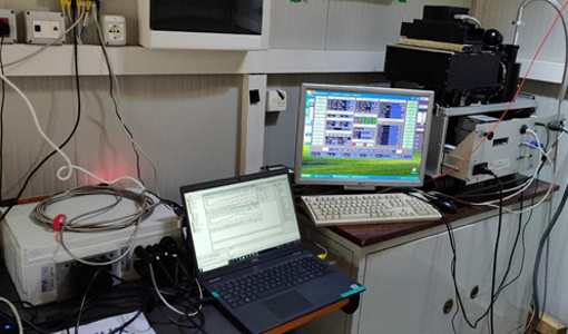
Ground-based campaigns support NO2 monitoring in Po Valley
The Po Valley in Italy is one of the most polluted regions in Europe. High NO2 concentrations often occur due to industrial and urban activities and the topography of the Po River basin, where the Alps and Apennines limit the dispersal of pollutants.
News - Data Release news
New Landsat-8 Collection-2 Level 1 and Level 2 data available from January
From the beginning of 2022, ESA will start the distribution of the European coverage of Landsat-8 Collection-2 Level 1 and Level 2 products.
Event - Workshop

Space and the Arctic 2009 Workshop
Temperatures in the Arctic are rising at an unprecedented rate. This workshop looked at the needs and challenges of working and living in the rapidly changing Arctic and explore how space-based services might help to meet those needs.
Event - Workshop
Insurance Industry Workshop on Earth Observation
This ESA workshop examined the potential value of satellite Earth Observation data to the insurance industry.
News - Events and Proceedings

Φ-Week Triumphs
In its fourth edition, Φ-Week presented the scientific community with amazing opportunities and projects—thus running alongside innovation at 360 degrees.
News - Infographics

ESA Third Party Missions timeline
We've released a new timeline to illustrate the history of the ESA Third Party Missions.
News - General News

Full version of QRAS Portal released
The new, full version, of the Quality Reports Advanced Search (QRAS) Portal launched today, adding new features to support users looking for Quality Control Reports on ESA and Third Party Missions.
Activity - General activities

GSCB and LTDP
The Copernicus programme is based on a fleet of European Earth observation satellites, built and operated by ESA, member states and commercial entities. Copernicus will also offer data from non-European satellites.
Activity - General activities

EO Science for Society
ESA's Earth Observation Science for Society programme aims to promote scientific exploitation of satellite data, forges new scientific discoveries and pioneers new services, stimulating downstream industrial and economic growth.