- All Categories (908)
- Data (15)
- News (31)
- Missions (3)
- Events (11)
- Tools (4)
- Activities (4)
- Documents (840)
Event - Workshop
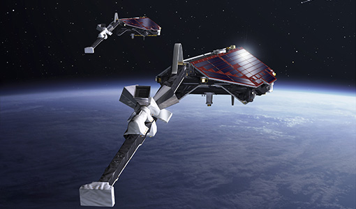
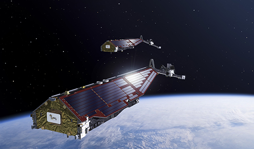
11th Swarm Data Quality Workshop
The 11th Swarm Data Quality Workshop was a hybrid event, which was instrumental in addressing the processing and use of Swarm data and defining a road map for future activities.
Event - Conference

15 Years of Progress in Radar Altimetry Symposium
A Symposium on "15 Years of Progress in Radar Altimetry" and the annual meeting of the Ocean Surface Topography Science Team, the International Doris Service Workshop and the ARGO Workshop.
Event - Conference
3rd ERS Symposium
The ESA Directorate for Observation of the Earth and its Environment held the 3rd ERS Symposium, in 1997, where many of the results from the ERS-1 and ERS-2 missions were presented and discussed by the scientific community.
News - Data Release news
Additional EFI TII Cross Track Flow dataset 0302 available for Swarm
Additional TII cross-track flow data is now available on the Swarm dissemination server for all the Swarm satellites.
News - Data Release news

Additional EFI TII Cross Track Flow dataset 0302 available for Swarm
Additional TII cross-track flow data is now available on the Swarm dissemination server for all the Swarm satellites.
News - Data Release news
Additional EFI TII Raw And Corrected Imagery and Spectra (TRACIS) dataset 0102 available for Swarm
Additional EFI TII Raw And Corrected Imagery and Spectra (TRACIS) data is now available on the Swarm dissemination server for all the Swarm satellites.
Tools - Other
AMPS
AMPS is a climatological model of polar ionospheric currents, based on magnetic field measurements from the CHAMP and Swarm satellites.
News - Data Release news
CHAMP L3 magnetic data now available on Swarm dissemination server
We are pleased to announce the release of magnetic field data from CHAMP mission on Swarm dissemination server.
News - Operational News
Changes to be introduced in the Swarm Dissemination FTP layout
Following a Swarm community recommendation, some changes will be introduced in the Swarm Dissemination FTP/HTTPS structure on 20 April 2022.
Activity - Projects
Contribution of Swarm data to the prompt detection of Tsunamis and other natural hazards
The main objective of COSTO (Contribution of Swarm data to the prompt detection of Tsunamis and other natural hazards) project is to better characterise, understand and discover coupling processes and interactions.
News - Events and Proceedings

Data preservation takes centre stage at Living Planet Symposium
Against the backdrop of the famed Rhine River, world-class scientists and Earth observation data-users are gathered this week in the historical city of Bonn, at the Living Planet Symposium (LPS).
Document - General Reference

Earth-Explorers-Satellites-to-understand-our-changing-Earth.pdf
This eight-page brochure provides an overview of the Earth Explorers currently in orbit and those under development.
Document - General Reference
Earth-Explorers.pdf
This flyer gives a quick overview of the 6 Earth Explorers missions.
Activity - General activities
EO Summer Schools
ESA's series of summer schools, on Monitoring of the Earth System, aims to promote the exploitation of Earth observation (EO) data.
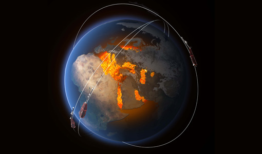
Mission - Heritage Missions

ERS
The ERS programme was composed of two missions, ERS-1 and ERS-2, which together observed the Earth for 20 years, from 1991 to 2011.
Data - Fast Registration with immediate access (Open)

ERS PRARE Precise Orbit Product (ERS.ORB.POD/ERS.ORB/PRC)
The precise orbit results from a data reduction process in which all available tracking data (Single-Lens Reflex, radar altimeter crossovers, PRARE range and Doppler data) and most accurate correction, transformation and dynamical models are taken into account and in which high level numerical procedures are applied. These orbits are "optimal" achievable representations of the real orbital motion under the circumstances of tracking situation and the "state of the art" model situation. The precise orbit product for the ERS satellites are the satellite ephemeris (position and velocity vector) including time tag, given in a well-defined reference frame, together with the nominal satellite attitude information and a radial orbit correction. Several orbit solutions are currently distributed: A new set of ORB POD (Precise Orbit Determination - REAPER v2) computed with the most updated model standards for the complete ERS-1 and ERS-2 mission. A previous set of ORB POD (REAPER v1) data already available on the ESA dissemination site since 2014, covering the ERS-1 full mission and the ERS-2 mission up to July 2003. ORB PRC which is the original Precise Orbit dataset computed during the ERS mission operations for ERS-1 and ERS-2. In the new POD dataset (REAPER v2) for the ERS-1 and ERS-2 missions, two different orbit solutions are provided together with the combined solution to be used for processing of the radar altimeter measurements and the determination of geodetic/geophysical products: those computed by DEOS (Delft Institute of Earth Observation and Space Systems), and those generated by ESOC (European Space Operations Centre) using different software (GEODYN and NAPEOS respectively). Careful evaluation of the various solutions of REAPER v2 has shown that the DEOS solution for both ERS-1 and ERS-2 has the best performance and is recommended to be used as reference. See the ERS Orbit Validation Report. For the previous version of the POD data set (REAPER v1), with ERS-2 mission data only up to 2003, three different orbit solutions together with the combined solution are available. These precise orbits for ERS-1 and ERS-2 have been computed at DEOS, ESOC, and GFZ (Deutschen GeoForschungsZentrums) using different software and different altimeter databases. Combined solutions have been created using three individual solutions for each satellite. All orbits were derived using consistent models in the same LPOD2005 terrestrial reference frame. These new orbit solutions show notable improvement with respect to DGME04 orbits (Scharroo and Visser, 1998). Thus, RMS crossover differences of new orbits improved by 4-9 mm. Careful evaluation of the various solutions has shown that the combined solution for both ERS-1 and ERS-2 has the best performance. All POD orbit files (REAPER v1/v2) are available in SP3c format.
Data - Fast Registration with immediate access (Open)
ERS-1/2 Radar Altimeter REAPER Geophysical Data Record - GDR [ERS_ALT_2]
This is a RA Geophysical Data Record (GDR) product containing radar range, orbital altitude, wind speed, wave height and water vapour from the ATSR/MWR as well as geophysical corrections. The REAPER (REprocessing of Altimeter Products for ERS) product is generated by applying a similar processing as for Envisat RA-2 on the Level 1b consolidated waveforms using 4 different re-trackers, RA calibration improvement, new precise orbit solution (POD), new ionospheric corrections (NICO09 until 1998 and GIM up to 2003), ECMWF ERA-interim model and updated SSB tables. This product contains two data rates: a low rate of 1 Hz and a high rate of 20 Hz. Most 1 Hz data is also represented at 20 Hz, while microwave radiometer (ATSR/MWR) data and the atmospheric and geophysical corrections are only given at 1 Hz. The REAPER GDR (ERS_ALT_2_) is a global product including data over ocean, ice and land. It should be noted that this product differs from the Envisat RA2 in the following ways: The product format; which is NetCDF (more details can be found in the Product Handbook, and not PDS The product is delivered based on orbit acquisition and not per pass (pole-to-pole). This product is extended through Envisat RA-2 data.
Data - Fast Registration with immediate access (Open)
ERS-1/2 Radar Altimeter REAPER METEO Product - [ERS_ALT_2M]
This is a RA Meteo product containing only the 1 Hz parameters for altimeter (surface range, satellite altitude, wind speed and significant wave height at nadir) and ATSR/MWR data (brightness temperature at 23.8 GHz and 36.5 GHz, water vapour content, liquid water content) used to correct altimeter measurements. It also contains the full geophysical corrections. This product corresponds to a subset of the REAPER GDR product (ERS_ALT_2_). The REAPER (REprocessing of Altimeter Products for ERS) product is generated by applying a similar processing as for Envisat RA-2 on the Level 1b consolidated waveforms using 4 different re-trackers, RA calibration improvement, new precise orbit solution (POD), new ionospheric corrections (NICO09 until 1998 and GIM up to 2003), ECMWF ERA-interim model and updated SSB tables. This product contains only the low rate of 1 Hz data. The REAPER Meteo (ERS_ALT_2M) is a global product including data over ocean, ice and land. It should be noted that this product differs from the Envisat RA2 in the following ways: The product format; which is NetCDF (more details can be found in the Product Handbook), and not PDS The product is delivered based on orbit acquisition and not per pass (pole-to-pole). This product is extended through Envisat RA-2 data.
Data - Fast Registration with immediate access (Open)
ERS-1/2 Radar Altimeter REAPER Sensor Geophysical Data Record - SGDR [ERS_ALT_2S]
This is a RA Geophysical Data Record (GDR) product containing radar range, orbital altitude, wind speed, wave height and water vapour from the ATSR/MWR as well as geophysical corrections. The REAPER (REprocessing of Altimeter Products for ERS) product is generated by applying a similar processing as for Envisat RA-2 on the Level 1b consolidated waveforms using 4 different re-trackers, RA calibration improvement, new precise orbit solution (POD), new ionospheric corrections (NICO09 until 1998 and GIM up to 2003), ECMWF ERA-interim model and updated SSB tables. This product contains two data rates: a low rate of 1 Hz and a high rate of 20 Hz. Most 1 Hz data is also represented at 20 Hz, while microwave radiometer (ATSR/MWR) data and the atmospheric and geophysical corrections are only given at 1 Hz. The REAPER GDR (ERS_ALT_2_) is a global product including data over ocean, ice and land. It should be noted that this product differs from the Envisat RA2 in the following ways: The product format; which is NetCDF (more details can be found in the Product Handbook, and not PDS The product is delivered based on orbit acquisition and not per pass (pole-to-pole). This product is extended through Envisat RA-2 data.