- All Categories (188)
- Data (1)
- News (4)
- Missions (4)
- Tools (2)
- Activities (4)
- Campaigns (3)
- Documents (170)
News - Data Release news

SMOS L2 Sea Surface Salinity products documentation updates
SMOS L2 Sea Surface Salinity product validation report is now available.
News - General News

Updated SMOS documentation available
Updated versions of several SMOS data documents are now available.
Document - General Reference

The Soil Moisture and Ocean Salinity Mission - SMOS
This document outlines the SMOS mission objectives and the derived scientific mission requirements.
Mission - Earth Explorers

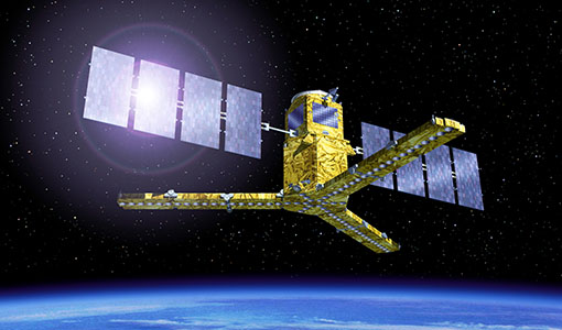
SMOS
The Soil Moisture and Ocean Salinity (SMOS) mission is dedicated to making global observations of soil moisture over land and salinity over oceans.
Data - Campaigns (Open)
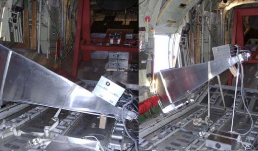
LOSAC
The L-band Ocean Salinity Airborne Campaign (LOSAC) objective is to understand the nature of the wind driven signatures in order to evaluate if corrections are necessary prior to salinity estimations based on the radiometer signals.
Campaign

DOMEX-1
The purpose of the DOMEX experiment was to acquire the first combined, in-situ microwave emission measurements using C- and L-band radiometers.
Mission - Heritage Missions

Landsat-4 and Landsat-5
The Landsat-4 and Landsat-5 missions continued the Landsat programme's goal of providing moderate-resolution optical remote sensing for land, coastal areas and shallow waters.
Mission - Heritage Missions

Landsat-1 to Landsat-3
The Landsat-1 to 3 satellites were the first in the United States' Landsat programme, dedicated to monitoring the Earth's land mass.
Campaign
LOSAC
The L-band Ocean Salinity Airborne Campaign (LOSAC) objective is to understand the nature of the wind driven signatures in order to evaluate if corrections are necessary prior to salinity estimations based on the radiometer signals.
Campaign

WISE
The objective of WInd and Salinity Experiment 2001 (WISE 2001) campaign was to get more data points and better wind speed measurements.
Activity - Quality

EDAP
The ESA Earthnet Data Assessment Pilot (EDAP) project will perform assessments for various missions to ensure the delivered data is fit for purpose.
Activity - Cal/Val activities
S2L8VegStruc
The Retrieval of vegetation structural variables from Sentinel-2/Landsat 8 time series study's objective is to test and validate the capabilities for the retrieval of structural variables.
Activity - Cal/Val activities
MBASSS
Mer Bleue Arctic Surrogate Simulation Site (MBASSS) Sentinel-2 and Landsat 8 Validation Project objectives are to develop capability to validate Landsat 8 Operational Land Imager land data products.
Tools - Visualisation
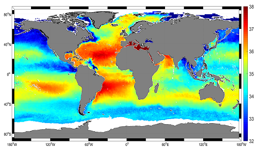
SMOS Global Mapping Tool
The SMOS Global Mapping Tool (GMT) is useful for plotting the SMOS data into a single global geographical map.
Activity - Quality
SLAP
The SLAP (Systematic Landsat Archive Processing) project covers the MSS, TM and ETM+ products from Landsat missions 1 – 7, and is the first systematic reprocessing of the ESA Landsat archive.
Document - Technical Note

SMOS-L1B-Data-Processing-Model-Document
The main purpose of this document is to provide a detailed definition of the processes and algorithms contained in the Foreign Sources Correction and Image Reconstruction modules for SMOS Level-1B products.
Tools - Processing
SMOS NetCDF Conversion Tool
The SMOS NetCDF Conversion Tool, for batch processing of large amounts of files, is available as a stand-alone command line executable or integrated in the SMOS Toolbox/SNAP.
News - Success Stories
Mapping salty waters
The length and precision with which climate scientists can track the salinity, or saltiness, of the oceans is set to improve dramatically.
News - Success Stories

ESA's Earth Explorers surpassing expectations
In this video, learn how each Earth Explorer mission is contributing to Earth science, and changing the way we look at our beloved planet.
Mission - Heritage Missions

Landsat-7
Landsat-7 is a joint USGS and NASA-led Earth observation mission, which was launched in 1999 and remains operational.