


Featured
About Landsat-7
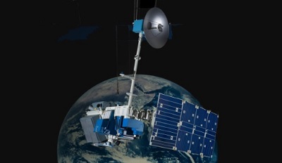
The Landsat programme is a joint USGS and NASA-led enterprise for Earth observation that represents the world's longest running system of satellites for moderate-resolution optical remote sensing for land, coastal areas and shallow waters.
Landsat-7 was launched in 1999 and nominal operations ended in April 2022, after which the mission proceeded as an experimental mission.
| Launch Date | 15 April 1999 |
| Orbit Height | 705 km |
| Orbit Type | Sun-synchronous polar |
| Repeat Cycle | 16 days |
| End of Service | 06 April 2022 |
| Inclination | 98.2° |
| Orbit Period | 99 min |
| Equatorial Crossing Time | 10:00 a.m |
| Onboard sensors provided under TPM | Enhanced Thematic Mapper Plus (ETM+) |
Landsat-7 is part of ESA's Third Party Missions Programme, in which ESA has an agreement to distribute data products from the missions.
Landsat-7 Objectives
Landsat-7 continues the goal of the Landsat programme to image repetitively Earth's land and coastal areas with the aim of monitoring changes to those areas over time. The satellite continues to provide data continuity for the Thematic Mapper aboard Landsat-4 and 5, utilising an enhanced version of the instrument.
Landsat-7 Instruments
find out more
Landsat-7 Data
DATA COLLECTIONS
Through the Online Dissemination server, ESA offers registered users access to the following Landsat-7 data collections:
DATA TOOLS
find out more
DATA QUALITY
Quality Control is monitoring routinely the status of the spacecraft (payload and platform) and to check if the derived products meet the quality requirements along mission life-time. Learn about the quality control activities for the ETM instrument: