- All Categories (14)
- News (3)
- Missions (1)
- Events (4)
- Activities (2)
- Documents (4)
News - Thematic area articles
Cloud-free collections key for land monitoring
Satellite imagery is a crucially important tool for monitoring the land, but cloud cover can often block parts of Earth’s surface from view, limiting subsequent analyses.
News - Success Stories
Commercial and international data for fire monitoring
As climate change sparks a surge in the frequency and intensity of wildfires, satellite data disseminated through ESA’s Third Party Missions (TPM) programme are helping scientists to track and investigate these potentially damaging natural events.
News - Success Stories
New worldwide dataset captures the planet in fine detail
Scientists have developed an open source planetwide dataset of high-resolution Earth observation imagery, thanks to commercial data delivered by ESA’s Third Party Missions (TPM) programme.
Event - Training
EO Summer School 3
ESA's series of summer schools, on Monitoring of the Earth System, aims to promote the exploitation of Earth observation data.
Event - Conference
Living Planet Symposium 2022
Learn about the 2022 edition of ESA's Living Planet Symposium.
Activity - Quality
EDAP
The ESA Earthnet Data Assessment Pilot (EDAP) project will perform assessments for various missions to ensure the delivered data is fit for purpose.
Activity - Quality
SLAP
The SLAP (Systematic Landsat Archive Processing) project covers the MSS, TM and ETM+ products from Landsat missions 1 – 7, and is the first systematic reprocessing of the ESA Landsat archive.
Mission - Heritage Missions
SPOT
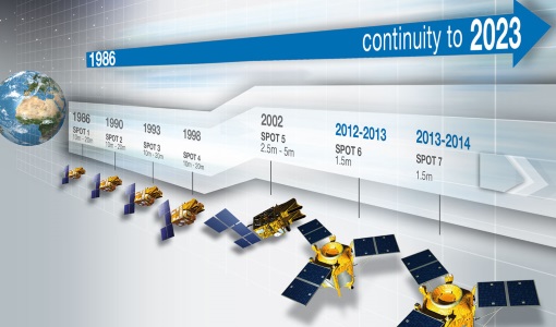
The SPOT (from French "Satellite pour l'Observation de la Terre") series of missions has been supplying high-resolution, wide-area optical imagery since 1986.
Event - Workshop
IDEAS+ Cal/Val Workshop 7
The 7th IDEAS+ Cal/Val Workshop took place on 4 and 5 June 2019 and it was hosted at the Wageningen University and Research (WUR) in The Netherlands.
Event - Workshop
CEOS-IVOS Workshop on Inter-comparison of Large Scale Optical and Infrared Sensors
The 2004 workshop was an opportunity to present and exchange experiences and knowledge from work on inter-comparing large scale optical sensors at different product levels.
Document - General Reference
Earth-from-Space-Middle-East.pdf
This brochure is a collection of ENVISAT ASAR and MERIS, PROBA, ERS-2, Landsat mosaics.
Document - General Reference
Earth-from-Space-Oceans-and-Coastal-Zone.pdf
This brochure is a collection of ERS-2 SAR; ENVISAT ASAR, MERIS, AATSR; Landsat TM and Proba CHRIS mosaics.
Document - General Reference
PREMIER-Report-for-Mission-Selection-An-Earth-Explorer-to-observe-atmospheric-composition.pdf
The objective of the PREMIER mission is to quantify the processes controlling global atmospheric composition in the mid/upper troposphere and lower stratosphere (5-25 km height range), which is a region of particular importance for climate change.
Document - Proceedings
Advances-in-Atmospheric-Science-and-Applications.pdf
Proceedings in Advances in Atmospheric Science and Applications held in 18-22 June 2012 in Bruges, Belgium.


