- Learn & Discover
- New Worldwide dataset captures...
New worldwide dataset captures the planet in fine detail
17 Nov 2022
Scientists have developed an open source planetwide dataset of high-resolution Earth observation imagery, thanks to commercial data delivered by ESA’s Third Party Missions (TPM) programme.
The product – called WorldStrat – is the most extensive and detailed dataset of its kind.
Later this month, it will be presented to more than 15,000 artificial intelligence researchers at the 36th Conference on Neural Information Processing Systems (NeurIPS 2022).
WorldStrat – which draws on imagery from both privately-owned and institutional missions – enables worldwide analyses and promotes the development of machine learning methods, such as techniques to enhance the resolution of images.
It has already been downloaded by users more than 3000 times, since its launch in June.
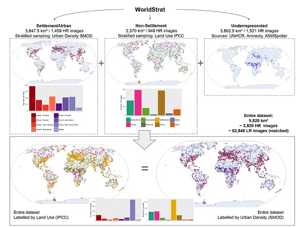
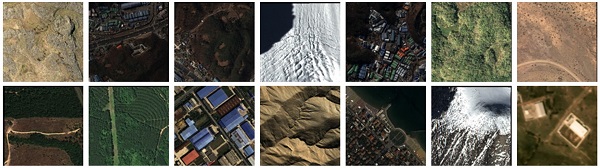
The dataset covers every type of location, urban density, and land use, making it suitable for countless applications, including disaster response, natural resource management and urban planning.
Work on WorldStrat began in 2021, as part of a project backed by ESA.
Julien Cornebise, Honorary Associate Professor at University College London and project lead, says, “The combination of high-resolution commercial imagery and machine learning has huge potential to enable planetwide analyses, which could help to tackle all kinds of global challenges – the problem is that commercial data are often locked behind a paywall.
“ESA’s TPM programme made our project possible by providing free access to data that would normally be very expensive.”
As part of the project, Cornebise and his colleagues drew on data delivered by the Airbus SPOT 6 and SPOT 7 missions, which were added to the TPM programme in 2012 and 2014, respectively. These satellites can provide imagery with resolutions as high as 1.5 m.
Around 4000 highly detailed SPOT images were used, covering some 10,000 square km of Earth’s surface.
In contrast to their high spatial resolution, these data often have a relatively low temporal resolution, as they are typically intended for specific commercial applications, rather than longer-term analyses.
To address this issue, freely available Copernicus Sentinel-2 data were used. These images are less detailed than SPOT images, but they are collected at regular time points.
Each SPOT image was temporally matched with 16 Sentinel images, which were captured at intervals of about five days. Around 64,000 Sentinel images were used in total.
To maximise the number of use cases, WorldStrat is built to have good coverage of multiple types of cities as well as non-urban areas, such as grassland, forests and ice caps. It also captures locations that are typically under-represented in Earth observation datasets, such as sites that need humanitarian aid.
The data and the code for WorldStrat is open to a range of users, enabling new possibilities for the testing and development of machine learning applications, as well as full reproducibility and extension. It can also enable the creation of new datasets with similar coverage properties and different sensors.
As part of the project, Cornebise and his colleagues explored one such use-case, the production of super-resolution imagery.
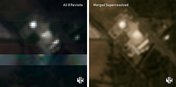
This consisted of reconstructing highly detailed pictures from multiple revisits at medium resolution.
The machine learning algorithms used to generate these reconstructions have been trained, rigorously benchmarked, and released to data users.
Cornebise concluded, “Super-resolution imagery is just one application of WorldStrat, but there are so many more potential uses of this dataset.
“Thousands of data users from around the world have already downloaded WorldStrat – and we look forward to seeing the ways in which they extend and improve it, using machine learning techniques.”
The project was supported by ESA’s Phi-Lab as part of the ESA-funded QueryPlanet project.
The project team included Julien Cornebise at University College London and Why How Ltd; Ivan Orsolic at Why How Ltd; and Freddie Kalaitzis at the University of Oxford.
WorldStrat is available for download.
References
J. Cornebise, I. Orsolic, F. Kalaitzis. (2022) High-Resolution Satellite Imagery: The WorldStrat Dataset – With Application to Super-Resolution, Advances in Neural Information Processing System 35, Proceedings of NeurIPS 2022.