- All Categories (28)
- Data (2)
- News (8)
- Missions (1)
- Events (13)
- Tools (3)
- Activities (1)
Event - Workshop

Volcanic Ash Monitoring - ESA/EUMETSAT Workshop
On 14 April 2010 the Icelandic volcano Eyjafjalla erupted and had been ejecting immense plumes of ash and sulphur into the atmosphere. The workshop was held in response to the emergency.
News - Operational News

Temporary interruption to Envisat AATSR dissemination service
A planned downtime will affect the access to the ftp dissemination server for the Envisat AATSR data during the period 13-15 February 2024.
Tools - Processing
SciaL1C Command-line Tool
The SCIAMACHY Calibration and Extraction Tool (SciaL1c) is an application to process SCIAMACHY Level 1b products. It allows you to select specific calibrations to apply to Level 1b data.
Event - Workshop
POLinSAR 2009
The 2009 workshop focused on theory and methods in the fields of SAR Polarimetry and Polarimetric Interferometry
Event - Workshop
POLinSAR 2007
The POLinSAR 2007 workshop was open to ESA Principal Investigators and co-investigators, scientists and students working in the field of SAR Polarimetry and Polarimetric Interferometry, and to representatives from national, European and international space agencies and value adding industry.
News - Data Release news
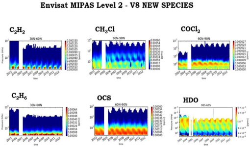
New Envisat MIPAS L2 dataset reprocessed with ORM v8.22 available
The Level 2 reprocessing of the full Envisat MIPAS mission with the ESA ORM processor version 8.22 has been completed.
Event - Conference

Living Planet Symposium 2022
Learn about the 2022 edition of ESA's Living Planet Symposium.
Event - Conference

Living Planet Symposium 2019
ESA's Living Planet Symposia are amongst the biggest Earth observation conferences in the world. Scientists present their latest findings on Earth's environment and climate.
News - Thematic area articles

How ESA uses space data to explore deep Earth
As anthropogenic activities continue to unbalance our environment, scientists strive to fully understand the intricate interactions within Earth’s system.
News - Success Stories

How Envisat helped to shape global understanding of Earth’s systems
Twenty years have passed since a ground-breaking European spacecraft designed to deliver unprecedented insight into the planet’s changing environment was lofted into orbit.
Tools - Apps

Heritage Missions app for Android
Download the Heritage Missions application to discover what the missions were about, how it worked and what the elements of the space and ground segment that make these missions unique.
Event - Conference

GRSG 2015 Conference
The 26th Annual GRSG Conference 'Challenges in Geological Remote Sensing' focused on a wide range of remote sensing applications, tools, latest developments and sensors.
Tools - Analysis

GOCE User Toolbox
The GOCE User Toolbox is a compilation of tools for the utilisation and analysis of products from ESA's GOCE gravity mission.
Event - Workshop
Fringe 2007 Workshop
Fringe 2007 was the third International Workshop on Envisat ASAR interferometry and fifth International Workshop on ERS SAR Interferometry.
Event - Workshop
Fringe 2005 Workshop
Fringe 2005 was the second International Workshop on Envisat ASAR interferometry and fourth International Workshop on ERS SAR Interferometry.
Event - Workshop
Fringe 2003 Workshop
The third ESA International Workshop on ERS SAR Interferometry and its first Workshop on ASAR interferometry: Advances in SAR interferometry from ERS and Envisat missions.
News - Infographics
Focusing on Envisat MERIS Full Resolution Level-2 data
ESA's Envisat mission continued and expanded upon the legacy of its predecessors, the ERS (European Remote Sensing) satellites. Operating between 2002 and 2012, the satellite's 10 instruments acquired a decade of data for many applications.
News - Data Release news
FDR4ALT - ESA unveils new cutting-edge ERS/Envisat Altimeter and Microwave Radiometer Datasets
The European Space Agency (ESA) has developed a comprehensive suite of innovative Earth system data records as part of the Fundamental Data Records for Altimetry project - FDR4ALT.
Activity - General activities
EO Summer Schools
ESA's series of summer schools, on Monitoring of the Earth System, aims to promote the exploitation of Earth observation (EO) data.
Event - Training

EO Summer School 8
ESA's series of summer schools, on Monitoring of the Earth System, aims to promote the exploitation of Earth observation data.