- All Categories (13)
- Data (5)
- News (5)
- Missions (1)
- Events (2)
News - Success Stories
Commercial and international data for fire monitoring
As climate change sparks a surge in the frequency and intensity of wildfires, satellite data disseminated through ESA’s Third Party Missions (TPM) programme are helping scientists to track and investigate these potentially damaging natural events.
News - Thematic area articles
Global understanding of Earth's land surfaces greatly boosted by satellite data
ESA perform land surface monitoring with a range of instruments onboard satellites acquiring optical and radar data. Collections of data from these missions are freely available for research purposes.
News - Infographics
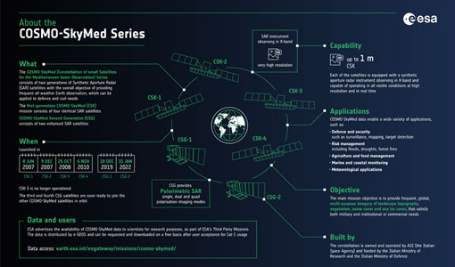
The COSMO-SkyMed series - Two generations of SAR satellites
Learn about the COSMO-SkyMed (Constellation of small Satellites for the Mediterranean basin Observation) series in our latest infographic.
News - Thematic area articles
Space helps monitor Earth’s changing biosphere
Earth’s biosphere is continually changing. Through its pioneering Earth observation missions, ESA is making critical contributions to monitor these changes and their impacts on Earth’s water and carbon cycles.
News - Thematic area articles
Satellite data boost global understanding of land surface
Understanding our changing land surface is essential in the study of climate change. Satellites are used to monitor changes to the material that covers Earth’s surface, so-called land cover, such as vegetation and water.
Data - EO Sign In Authentication (Open)
JERS-1 OPS (Optical Sensor) Very Near Infrared Radiometer (VNIR) System Corrected Products level 1
The JERS-1 Optical System (OPS) is composed of a Very Near Infrared Radiometer (VNIR) and a Short Wave Infrared Radiometer (SWIR). The instrument has 8 observable spectral bands from visible to short wave infrared. Data acquired by ESA ground stations The JERS-1 OPS products are available in GeoTIFF format. These products are available only for the VNIR sensor. All four bands are corrected. The correction consists in a vertical and horizontal destriping, the radiometry values are expanded from the range [0.63] to the range [0.255]. No geometrical correction is applied on level 1. The pixel size of approximately 18 x 24.2 metres for raw data is newly dimensioned to 18 x 18 metres for System Corrected data using a cubic convolution algorithm. Disclaimer: Cloud coverage for JERS OPS products has not been computed using an algorithm. The cloud cover assignment was performed manually by operators at the acquisition stations. Due to missing attitude information, the Nadir looking band (band 3) and the corresponding forward looking band (band 4) are not well coregistered, resulting in some accuracy limitations. The quality control was not performed systematically for each frame. A subset of the entire JERS Optical dataset was selected and manually checked. As a result of this, users may occasionally encounter issues with some of the individual products. Spatial coverage: Check the spatial coverage of the collection on a map available on the Third Party Missions Dissemination Service.
Data - EO Sign In Authentication (Open)
JERS-1 SAR Level 1 Precision Image
The JSA_PRI_1P product is comparable to the ESA PRI/IMP images generated for Envisat ASAR and ERS SAR instruments. It is a ground range projected detected image in zero-Doppler SAR coordinates, with a 12.5 metre pixel spacing. It has four overlapping looks in Doppler covering a total bandwidth of 1000Hz, with each look covering a 300Hz bandwidth. Sidelobe reduction is applied to achieve a nominal PSLR of less than -21dB. The image is not geocoded, and terrain distortion (foreshortening and layover) has not been removed. Data acquired by ESA ground stations. Spatial coverage: Check the spatial coverage of the collection on a map available on the Third Party Missions Dissemination Service.
Data - EO Sign In Authentication (Open)
JERS-1 SAR Level 1 Single Look Complex Image
The JSA_SLC_1P product is comparable to the ESA SLC/IMS images generated for Envisat ASAR and ERS SAR instruments. It is a slant-range projected complex image in zero-Doppler SAR coordinates. The data is sampled in natural units of time in range and along track, with the range pixel spacing corresponding to the reciprocal of the platform ADC rate and the along track spacing to the reciprocal of the PRF. Data is processed to an unweighted Doppler bandwidth of 1000Hz, without sidelobe reduction. The product is suitable for interferometric, calibration and quality analysis applications. Data acquired by ESA ground stations. Spatial coverage: Check the spatial coverage of the collection on a map available on the Third Party Missions Dissemination Service.
Data - Project Proposal (Restrained)
COSMO-SkyMed full archive and tasking
The archive and new tasking X-band SAR products are available from COSMO-Skymed (CSK) and COSMO-SkyMed Second Generation (CSG) missions in ScanSAR and Stripmap modes, right and left looking acquisition (20 to 60° incidence angle). COSMO-SkyMed modes: Acquisition Mode Single look Resolution [Az. X. Rg, SCS] (m) Scene size [Az. X. Rg] (km) Polarisation Scene duration (seconds) Number of looks Multilook resolution (m) Geolocation accuracy ±3 s (m) [DGM, GEC, GTC] Stripmap Himage 2.6 x 3 40 x 40 Single: HH, HV, VH, VV 7 3 5 25 Stripmap PingPong 9.7 x 11 30 x 30 Alternate: HH/VV, HH/HV, VV/VH 6 3 20 25 ScanSAR Wide 23 x 13.5 100 x 100 Single: HH, HV, VH, VV 15 4 - 9 30 30 ScanSAR Huge 38 x 13.5 200 x 200 Single: HH, HV, VH, VV 30 25 - 66 100 100 COSMO-Skymed Second Generation Modes: Acquisition Mode Single look Resolution [Az. X. Rg, SCS] (m) Scene size [Az. X. Rg] (km) Polarisation Scene duration (seconds) Number of looks Multilook resolution (m) Geolocation accuracy ±3σ (m) [DGM, GEC, GTC] Stripmap 3 x 3 40 x 40 Single (HH, VV, HV, VH) or Dual (HH+HV, VV+VH) 7 2 x 2 4 x 4 6 x 7 11 x 14 3.75 Stripmap PingPong 12 x 5 30 x 30 Alternate (HH/VV, HH/HV+VV/VH) 6 1 x 2 2 x 5 12 x 10 23 x 26 12 QuadPol 3 x 3 40 x 15 Quad (HH+HV+VV+VH) N/A 2 x 2 4 x 4 6 x 7 11 x 14 3.75 ScanSAR 1 20 x 4 100 x 100 Single (HH, VV, HV, VH) or Dual (HH+HV, VV+VH) 15 1 x 3 1 x 5 2 x 8 20 x 14 23 x 27 35 x 40 12 ScanSAR 2 40 x 6 200 x 200 Single (HH, VV, HV, VH) or Dual (HH+HV, VV+VH) 30 1 x 4 1 x 7 3 x 16 40 x 27 47 x 54 115 x 135 12 Following Processing Levels are available, for both CSK and CSG: SCS (Level 1A, Single-look Complex Slant): Data in complex format, in slant range projection (the sensor's natural acquisition projection) and zero doppler projection, weighted and radiometrically equalised; the coverage corresponds to the full resolution area illuminated by the SAR instrument DGM (Level 1B, Detected Ground Multi-look): Product obtained detecting, multi-looking and projecting the Single-look Complex Slant data onto a grid regular in ground: it contains focused data, amplitude detected, optionally despeckled by multi-looking approach, radiometrically equalised and represented in ground/azimuth projection GEC (Level 1C, Geocoded Ellipsoid Corrected): Focused data, amplitude detected, optionally despeckled by multi-looking approach, geolocated on the reference ellipsoid and represented in a uniform preselected cartographic presentation. Any geometric correction derived by usage of terrain model isn't applied to this product by default GTC (Level 1D, Geocoded Terrain Corrected): Focused data, fully calibrated with the usage of terrain model, amplitude detected, optionally despeckled by multi-looking approach, geolocated on a DEM and represented in a uniform preselected cartographic presentation. The image scene is located and accurately rectified onto a map projection, through the use of Ground Control Points (GCPs) and Digital Elevation Model (DEM); it differs from GEC for the use of the DEM (instead of reference ellipsoid) for the accurate conversion from slant to ground range and to approximate the real earth surface. The list of available data can be retrieved using the CLEOS COSMO-SkyMed products catalogue. User registration is required to use the catalogue. As per ESA policy, very high-resolution data over conflict areas cannot be provided.
Data - Project Proposal (Restrained)
COSMO-SkyMed ESA archive
The COSMO-SkyMed archive collection consists of COSMO-SkyMed products requested by ESA supported projects over their areas of interest around the world. The dataset regularly grows as ESA collects new products over the years. The following list delineates the characteristics of the SAR measurement modes that are disseminated under ESA Third Party Missions (TPM). STRIPMAP HIMAGE (HIM): Achieving medium resolution (3 m x 3 m single look), wide swath imaging (swath extension ≥40 km). STRIPMAP PINGPONG (SPP): Achieving medium resolution (15 m), medium swath imaging (swath ≥30 km) with two radar polarization's selectable among HH, HV, VH and VV. SCANSAR WIDE (SCW): Achieving radar imaging with swath extension of 100 x 100 km2 and a spatial resolution of 30 x 30 m2. SCANSAR HUGE (SCH): Achieving radar imaging with swath extension of 200 x 200 km2 and a spatial resolution selectable of 100 x 100 m2. Processing Levels: Level 1A - Single-look Complex Slant - (SCSB and SCSU): RAW data focused in slant range-azimuth projection, that is the sensor natural acquisition projection; product contains In-Phase and Quadrature of the focused data, weighted and radiometrically equalised.The processing of the 1A_SCSU product differs from that of the 1A_SCSB product for the following features:a non-weighted processing is performed, which means that windowing isn't applied on the processed bandwidth; radiometric equalisation (in terms of compensation of the range antenna pattern and incidence angle) is not performed; hence only compensation of the antenna transmitter gain and receiver attenuation and range spreading loss is applied. Level 1B - Detected Ground Multi-look (DGM): Product obtained detecting, multi-looking and projecting the Single-look Complex Slant data onto a grid regular in ground. Spotlight Mode products are not multi-looked. Level 1C - Geocoded Ellipsoid Corrected (GEC) and Level 1D - Geocoded Terrain Corrected (GTC): Obtained projecting the Level 1A product onto a regular grid in a chosen cartographic reference system. In case of Lev 1C the surface is the earth ellipsoid while for the Lev 1D a DEM (Digital Elevation Model) is used to approximate the real earth surface. Spatial coverage: Check the spatial coverage of the collection on a map available on the Third Party Missions Dissemination Service. As per ESA policy, very high-resolution data over conflict areas cannot be provided.
Event - Workshop
POLinSAR 2019
ESA organised POLinSAR 2019, the 9th International Workshop on Science and Applications of SAR Polarimetry and Polarimetric Interferometry.
Event - Meeting
VH-RODA and CEOS SAR workshop
The workshop provided an open forum for the presentation and discussion of current status and future developments related to the calibration and validation of space borne very high-resolution SAR and optical sensors and data products.
Mission - Heritage Missions
JERS-1
The overall objectives of JERS-1 (Japanese Earth Resources Satellite) were the generation of global data sets with SAR and OPS sensors aimed at surveying resources, establishing an integrated Earth observation system


