- All Categories (273)
- Data (3)
- News (24)
- Missions (2)
- Events (10)
- Tools (9)
- Activities (5)
- Documents (220)
Data - Data Description
TropForest - ALOS, GEOSAT-1 & KOMPSAT-2 optical coverages over tropical forests
The objective of the ESA TropForest project was to create a harmonised geo-database of ready-to-use satellite imagery to support 2010 global forest assessment performed by the Joint Research Centre (JRC) of the European Commission and by the Food and Agriculture Organization (FAO). Assessments for year 2010 were essential for building realistic deforestation benchmark rates at global to regional levels. To reach this objective, the project aimed to create a harmonised ortho-rectified/pre-processed imagery geo-database based on satellite data acquisitions (ALOS AVNIR-2, GEOSAT-1 SLIM6, KOMPSAT-2 MSC) performed during year 2009 and 2010, for the Tropical Latin America (excluding Mexico) and for the Tropical South and Southeast Asia (excluding China), resulting in 1971 sites located at 1° x 1° geographical lat/long intersections. The project finally delivered 1866 sites (94.7% of target) due to cloud coverages too high for missing sites. Spatial coverage: Check the spatial coverage of the collection on a map available on the Third Party Missions Dissemination Service.
Document - User Guide
TPM-L-OADS-dissemination-service-User-Manual.pdf
This guide describes the Third Party Missions Dissemination System.
News - Infographics
Timeline to over 40 years of historical satellite missions
ESA's Heritage Space Programme preserves historical data from over 40 years of Earth observation missions.
Document - User Guide
Third Party Missions, Cat-1 Data Availability
This brochure gives a quick overview on the availability of the Third Party Missions IRS-P3, JERS-1, NIMBUS, Proba, Landsat, KOMPSAT-1, SCISAT-1, Terra/Aqua, NOAA, QSCAT, OrbView, SPOT-1,-2,-3,-4, ALOS.
Document - General Reference
Third Party Missions Brochure
This brochure summarises ESA's Third Party Missions programme, providing a timeline and examples of content related to some of the missions.
Document - General Reference
The International Charter- Space and Major Disasters
The Charter is an important step forward in linking the needs of disaster and relief organisations with space technology solutions to help mitigate the effects of disaster on human life, property and the environment.
Document - General Reference
The Earth Observation Handbook, 2010 Update - Key Tables
This is the 2010 update of the CEOS Earth Observation Handbook. You can browse the live database at http://database.eohandbook.com/ or download the printable PDF of key tables based on the 2010 database contents for a handy reference.
Document - General Reference
surface-reflectance-aerosol-properties-proba-v-observations-abstract.pdf
Joint Retrieval Of Surface Reflectance And Aerosol Properties: Application To Proba-V Observations
Document - General Reference
Sterckx-Sindy-ICOS-2017.pdf
Poster presentation at IOCS (International Ocean Colour Science) 2017, 5 -19 May 2017, Lisbon, Portugal.
Tools - Analysis
SNAP
SNAP is a common architecture for all Sentinel Toolboxes. It is ideal for Earth observation processing and analysis.
News - Success Stories
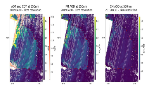
Ship trails in the Bay of Biscay observed using PROBA-V imagery
Ship trails have been perceived as convincing evidence of aerosol-cloud interaction. Ship emissions have been proven to contribute by about 1.9% and 2.9% to the increase in the global total and fine-mode aerosol optical thickness (AOT) respectively over a five year period (Peters et al. 20212).
Tools - Analysis
Sentinel-3 Toolbox
The Toolbox consists of a set of visualisation, analysis and processing tools for the exploitation of OLCI and SLSTR data.
Tools - Analysis
Sentinel-2 Toolbox
The Toolbox consists of a rich set of visualisation, analysis and processing tools for the exploitation of optical high-resolution products including the Sentinel-2 MSI sensor.
News - Thematic area articles
Satellite data boost global understanding of land surface
Understanding our changing land surface is essential in the study of climate change. Satellites are used to monitor changes to the material that covers Earth’s surface, so-called land cover, such as vegetation and water.
Document - Technical Note
Review of semi-empirical BRDF models performance on Proba-V and Spot-Vgt time series
Proba-V heritage mission: SPOT-VGT data processing and dissemination - Scientific paper providing overview of SPOT-VGT 15-years of data processing and dissemination
News - General News
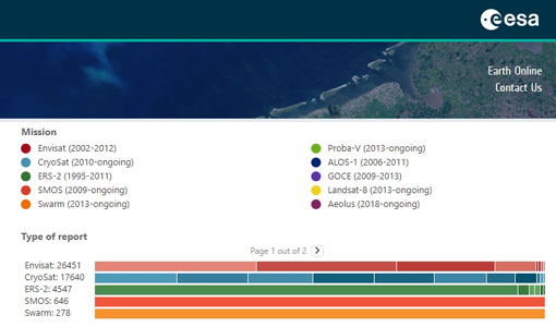
Quality Reports Advanced Search Portal takes off
The Quality Reports Advanced Search (QRAS) Portal is a system that provides a set of functionalities for searching, filtering, visualising and downloading of Earth Observation reports data, from multiple missions.
Document - General Reference
PV-LAC-COAST-VR-v2.0.pdf
This is the second version (V2) of the Validation Report for the PV-LAC coastal activities.
Document - General Reference
PV-LAC-COAST-SR-v1.1.pdf
In the frame of the PV-LAC project a prototype code has been developed, tested and validated for the atmospheric correction (A/C) and turbidity retrieval of PROBA-V data over turbid coastal areas.


