- All Categories (33)
- Data (5)
- News (13)
- Missions (2)
- Events (1)
- Tools (5)
- Documents (7)
Mission - Heritage Missions
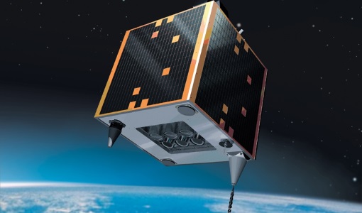
GEOSAT-1
GEOSAT-1 is part of a group of satellites collectively known as the Disaster Monitoring Constellation (DMC).
Event - Meeting

VH-RODA and CEOS SAR workshop
The workshop provided an open forum for the presentation and discussion of current status and future developments related to the calibration and validation of space borne very high-resolution SAR and optical sensors and data products.
Mission - Heritage Missions
GEOSAT
The GEOSAT series consists of GEOSAT-1 and GEOSAT-2 missions. They are Earth imaging satellites. GEOSAT-2, a high resolution satellite, became the first European fully-private satellite capable of providing sub-metric multi-spectral imagery.
Tools - Analysis

Sentinel-2 Toolbox
The Toolbox consists of a rich set of visualisation, analysis and processing tools for the exploitation of optical high-resolution products including the Sentinel-2 MSI sensor.
Tools - Analysis

Sentinel-3 Toolbox
The Toolbox consists of a set of visualisation, analysis and processing tools for the exploitation of OLCI and SLSTR data.
Data - Data Description
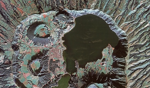
TropForest - ALOS, GEOSAT-1 & KOMPSAT-2 optical coverages over tropical forests
The objective of the ESA TropForest project was to create a harmonised geo-database of ready-to-use satellite imagery to support 2010 global forest assessment performed by the Joint Research Centre (JRC) of the European Commission and by the Food and Agriculture Organization (FAO). Assessments for year 2010 were essential for building realistic deforestation benchmark rates at global to regional levels. To reach this objective, the project aimed to create a harmonised ortho-rectified/pre-processed imagery geo-database based on satellite data acquisitions (ALOS AVNIR-2, GEOSAT-1 SLIM6, KOMPSAT-2 MSC) performed during year 2009 and 2010, for the Tropical Latin America (excluding Mexico) and for the Tropical South and Southeast Asia (excluding China), resulting in 1971 sites located at 1° x 1° geographical lat/long intersections. The project finally delivered 1866 sites (94.7% of target) due to cloud coverages too high for missing sites. Spatial coverage: Check the spatial coverage of the collection on a map available on the Third Party Missions Dissemination Service.
Document - User Guide

TPM-L-OADS-dissemination-service-User-Manual.pdf
This guide describes the Third Party Missions Dissemination System.
News - General News

ESA’s Earth Observation Catalogue and its services
EO-CAT is the EO Catalogue tool allowing users to search ESA and Third Party Mission collections.
News - General News

ESA's new DataCube service is now available
ESA is pleased to announce the deployment of a new service, called ESA PDGS-DataCube, enabling multi-temporal and pixel-based access to a subset of the data available in the European Space Agency dissemination services.
Tools - Analysis

ESA PDGS Jupyter Notebook
A series of Jupyter Notebooks are available, in order to understand how to exploit the API that provides the data access service for different types of datasets included in the ESA PDGS datacube.
Document - User Guide
GEOSAT-1-Imagery-User-Guide.pdf
The GEOSAT-1 Imagery User Guide provides the essential information about GEOSAT-1 products and services to its users.
News - Success Stories

A stroll through Heritage Missions
At ESA's Earth Observation centre—ESRIN—in Frascati, Italy, there is a place where one can walk back in time, to better understand the history and importance of Heritage Missions and their data.
Document - Technical Note

GEOSAT-1-2-Terms-Of-Applicability.pdf
This document contains the Terms and Conditions for access to Deimos data (both Deimos 1 & 2).
News - Infographics

ESA Third Party Missions timeline
We've released a new timeline to illustrate the history of the ESA Third Party Missions.
News - Infographics

An overview of ESA's Third Party Missions programme
ESA’s Third Party Missions programme consists of almost 50 satellite missions, which are owned by organisations around the world. ESA has agreements with these organisations to acquire, process, and distribute data from their missions
Data - Project Proposal (Restrained)
GEOSAT-1 full archive and tasking
GEOSAT-1 full archive and new tasking products are available at 22 m resolution in two processing levels. L1R (Basic Geopositioned): All 3 spectral channels combined into a band-registered image. Geopositioned product based on sensor model. Coefficients derived from satellite orientation parameters coming from telemetry and appended to metadata L1T (L1R orthorectified): Orthorectified to sub-pixel accuracy (10 metres RMS error approximately) with respect to Landsat ETM+ reference data and hole-filled seamless SRTM DEM data V3, 2006 (90 m). GEOSAT-1 products are provided in DIMAP format. The image products are delivered in the TIFF and GeoTIFF image formats by default. All products can be provided in False Colours (R,G,NIR) or Natural Colours (R, G, Synthetic Blue).
News - Success Stories

How GEOSAT helps to unlock the potential of Earth observation data
High-resolution imagery delivered by a privately-owned system of European satellites is facilitating international efforts to boost prosperity, protect the environment, and tackle urgent global challenges.
Data - Fast Registration with approval (Restrained)
GEOSAT-1 and 2 ESA archive
GEOSAT-1 and 2 dataset is composed of products acquired by the GEOSAT-1 and GEOSAT-2 Spanish satellites. The dataset regularly grows as ESA collects new products. GEOSAT-1 standard products offered are: SL6_22P: SLIM6, 22m spatial resolution, from bank P SL6_22S: SLIM6, 22m spatial resolution, from bank S SL6_22T: SLIM6, 22m spatial resolution, 2 banks merged together. GEOSAT-1 products are available in two different processing levels: Level 1R: All 3 Spectral channels combined into a band-registered image using L0R data. Geopositioned product based on rigorous sensor model. Coefficients derived from internal and external satellite orientation parameters coming from telemetry and appended to metadata. Level 1T: Data orthorectified to sub-pixel accuracy (10 metres RMS error approximately) with respect to Landsat ETM+ reference data and hole-filled seamless SRTM DEM data V3, 2006 (90 m). The use of the GCPs, it is not automatic, as it is done manually, which gives greater precision. (GCPs by human operators). GEOSAT-2 standard products offered are: Pan-sharpened (HRA_PSH four-band image, HRA_PS3 321 Natural Colours, HRA_PS4 432 False Colours): a four-band image, resulting from adding the information of each multispectral band to the panchromatic band. The fusion does not preserve all spectral features of the multispectral bands, so it should not be used for radiometric purposes. Panchromatic (HRA_PAN): a single-band image acquired by the panchromatic sensor. Multispectral (HRA_MS4): a four-band image acquired by the multispectral sensor, with band co-registration. Bundle (HRA_PM4): a five-band image contains the panchromatic and multispectral products packaged together, with band co-registration. Stereo Pair (HRA_STP): The image products obtained from two acquisitions of the same target performed from different viewpoints in the same pass by using the agility feature of the platform. It can be provided as a pair of pan sharpened or panchromatic images. GEOSAT-2 products are available in two different processing levels: Level 1B: A calibrated and radiometrically corrected product, but not resampled. The product includes the Rational Polynomial Coefficients (RPC), the metadata with gain and bias values for each band, needed to convert the digital numbers into radiances at pixel level, and information about geographic projection (EPGS), corners geolocation, etc. Level 1C: A calibrated and radiometrically corrected product, manually orthorectified and resampled to a map grid. The geometric information is contained in the GeoTIFF tags. Spatial coverage: Check the spatial coverage of the collection on a map available on the Third Party Missions Dissemination Service. As per ESA policy, very high-resolution imagery of conflict areas cannot be provided.
News - Success Stories

New open-source Python library improves rapid mapping services
In emergency services, rapid response is paramount. ICube-SERTIT’s Rapid Mapping Service provides near real-time delivery of geo-information to help emergency services respond quickly to disasters such as flooding, fires and landslides. A new Python open-source library, called EOReader, speeds up this mapping response by enabling the easy opening of imagery from multiple satellite sensors, both optical and synthetic aperture radar (SAR).
Document - General Reference

Third Party Missions Brochure
This brochure summarises ESA's Third Party Missions programme, providing a timeline and examples of content related to some of the missions.