- All Categories (36)
- Data (12)
- News (9)
- Missions (3)
- Events (1)
- Tools (1)
- Activities (6)
- Campaigns (3)
- Documents (1)
News - Events and Proceedings
Scientists to showcase value of Earth observation data at EGU
Remote sensing scientists are getting ready to present innovative and exciting applications of satellite data at the European Geosciences Union general assembly which will take place from 24 to 28 April in Vienna, Austria.
Activity - Projects
ESA's multi-level global thermosphere data products consistent with Swarm and GRACE (-FO)
In this project, the possibility of using the space-based along-track Thermospheric Neutral Density (TND) estimates for generating the European Space Agency (ESA)'s Level 3 (L3) global multi-level TND data products is assessed.
Activity - Projects

Swarm Ionospheric Polar Electrodynamics
The goal of the Swarm ionospheric polar electrodynamics (SWIPE) project is to create and disseminate the most advanced models of high-latitude Joule dissipation, ionospheric convection, and ionospheric conductances.
News - Success Stories

Drones join the campaign to validate Aeolus data
In June and September 2022, the Askos component of the Joint Aeolus Tropical Atlantic Campaign (JATAC), organised by ESA and its international partners, was expanded with new ground-based, drone and radiosonde measurements. The main objective of this campaign was to calibrate and validate Aeolus satellite observations.
Activity - Projects
Swarm Ion Temperature Estimation
The main objective of Swarm Ion Temperature Estimation (SITE) project is to estimate ion temperatures along the orbits of Swarm satellites using available LP electron density and temperature measurements, and numerical models.
Activity - Projects
Plasmapause Related boundaries in the topside Ionosphere as derived from Swarm Measurements
In the project, Plasmapause Related boundaries in the topside Ionosphere as determined from Swarm Measurements (PRISM), the team develop products that characterise position of the plasmapause related phenomena in the topside ionosphere.
News - Thematic area articles

Space data help to unravel the complexities of Earth’s atmosphere
As the impacts of the climate crisis intensify, scientists are using ESA’s Earth observation archives to investigate atmospheric processes and their influences on the planet’s changing environment.
News - Events and Proceedings

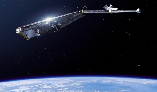
Exploring the prevailing achievements and future directions of Aeolus
A tight-knit community of European remote sensing experts converged on the Italian island of Sicily last month to discuss how the strong success of ESA’s Aeolus mission is shaping scientists’ understanding of the winds that sweep across the planet.
Tools - Processing
Aeolus VRE
The Aeolus Virtual Research Environment (VRE) is the latest extension to the VirES for Aeolus service, which offers more direct and in-depth data exploitation of the Aeolus mission. The VRE is a cloud service that provides a web-based development environment in the form of a JupyterLab workspace.
News - General News

Launch of Aeolus VRE
The Aeolus Virtual Research Environment (VRE) is a cloud service, which provides users with a web-based development environment in the form of a JupyterLab workspace.
News - Success Stories

How Envisat helped to shape global understanding of Earth’s systems
Twenty years have passed since a ground-breaking European spacecraft designed to deliver unprecedented insight into the planet’s changing environment was lofted into orbit.
News - Success Stories

Dust aerosol campaign validates Aeolus data
Prepared, implemented and executed by a consortium of French universities and research institutions, under the umbrella of the French Space Agency (CNES) and the French National Centre for Scientific Research (CNRS), the Clouds-Atmospheric Dynamics–Dust Interactions in West Africa (CADDIWA) campaign took place on Sal Island in Cape Verde, from 6 to 25 September 2021.
Data - External Data (Restrained)
Odin OSIRIS data products
The Odin OSIRIS (Optical Spectrograph and Infra-Red Imaging System) data provides vertical profiles measures of spectrally dispersed, limb scattered sunlight from the upper troposphere into the lower mesosphere. The data products are regularly processed and provide Ozone density vertical profiles (both Level 2 and Level 3), vertical profiles of stratospheric Aerosol (both Level 2 and Level 3), slant column densities of nitrogen dioxide NO2 profiles (Level 2), stratospheric BrO profiles (Level 2).
Activity - Projects
VERA
VERtical coupling in Earth's Atmosphere at mid and high latitudes (VERA) is a project in response to the ESA ITT "Swarm+ Coupling: High-Low Atmosphere Interactions" with the duration of 16 months.
Activity - Projects
Swarm Outflow
The Swarm+ Coupling High-Low Atmosphere Interactions: Ion Outflow ("Swarm+ Outflow") project, which began in May 2019, centres on using Swarm spacecraft to tackle unanswered questions around non-thermal processes that lead to ion outflow.
Data - Announcement of Opportunity (Restrained)

Announcement of Opportunity for NoR
ESA invites submissions for the Network of Resources (NoR) call, which aims to support research, development and pre-commercial users to innovate their working practices, moving from a data download paradigm towards a 'bring the user to the data' paradigm.
Document - Product Handbook

AVHRR-Handbook.pdf
The AVHRR user handbook provides details about the content of the consolidated and harmonised data set archived at ESA facilities.
News - Success Stories

Gravity Field Models from Swarm data
In addition to its geomagnetic objectives, GPS receivers onboard Swarm can and have already been exploited to measure temporal variations in Earth's global gravity field.
News - Success Stories

COVID-19: Aeolus and weather forecasts
The drop in commercial flights has led to fewer measurements for weather forecasts, but fortunately, ESA’s Aeolus satellite mission is helping to fill the gap.
Data - EO Sign In Authentication (Open)

Envisat MIPAS L1 - Geo-located and calibrated atmospheric spectra [MIP_NL__1P]
This MIPAS Level 1 data product covers the geo-located, spectrally and radiometrically calibrated limb emission spectra in the 685-2410 cm-1 wave number range. It comprises 5 bands: 685-980 cm-1, 1010-1180 cm-1, 1205-1510 cm-1, 1560-1760 cm-1, 1810-2410 cm-1 and covers the following spatial ranges: Tangent height range: 5 to 170 km Pointing range: (azimuth pointing range relative to satellite velocity vector): 160° - 195° (rearward anti-flight direction); 80° - 110° (sideward anti-Sun direction). The instantaneous field of view (IFOV) is 0.05230 (elevation) x 0.5230 (azimuth)°. The length of measurement cell for an individual height step is approximately 300-500 km (dependent on tangent height and optical properties of the atmosphere). The spectral resolution spans from 0.030 to 0.035 cm-1, with a radiometric sensitivity of 4.2 to 50 nW / cm-1 / sr / cm2. The resolution range of the dataset is: 3 km (vertical) x 30 km (horizontal) at the tangent point. Please consult the Product Quality Readme file for MIPAS Level 1b IPF 8.03 before using the data.