- Learn & Discover
- Drones join the campaign to va...
Drones join the campaign to validate Aeolus data
24 Nov 2022
In June and September 2022, the Askos component of the Joint Aeolus Tropical Atlantic Campaign (JATAC), organised by ESA and its international partners, was expanded with new ground-based, drone and radiosonde measurements. The main objective of this campaign was to calibrate and validate Aeolus satellite observations.
The heading is symbolic: Askos is the Greek name of the legendary bag that contains all the storm-currents for Aeolus—the God of the winds—to use.
Operating out of the island of São Vicente in Cabo Verde, Askos made high quality wind, aerosol and cloud observations.
This final phase of the Askos campaign – a continuation of the 2021 Askos campaign – focussed on the impact of desert dust on tropical convection, clouds and radiation.
Aiming to understand Saharan dust
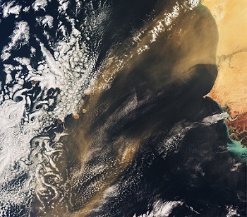
The Sahara is the largest source of windblown dust in the world, most of which is transported by atmospheric circulation towards the Atlantic and the Americas, directly over Cabo Verde.
Dust plays a key role in Earth’s system by influencing weather and the climate, and by delivering nutrients to marine and terrestrial ecosystems. The impact on society is also significant, affecting air quality, aviation and solar energy generation. However, much of the behaviour and influence of Saharan dust is not yet fully known.
This is one of the areas in which Aeolus data are expected to have a large impact on weather forecasting and atmospheric sciences. The Doppler wind lidar instrument on Aeolus provides global wind profile observations, information on cloud top heights and the vertical distribution of thin clouds and aerosols, including dust.
Askos instruments operated in synergy with equipment of the ERC D-TECT project, which hopes to explain the long-range transport of the large dust particles by studying the role of triboelectrification (contact electrification).
Another objective, pursued in collaboration with the University of Reading (United Kingdom), is to compare the giant dust particles in the air during the day and at night.
Measurements from below
The ground-based component of Askos was designed, deployed and implemented by the National Observatory of Athens (NOA), in close collaboration with the Leibniz Institute for Tropospheric Research (TROPOS), the Romanian National Institute for Research and Development for Optoelectronics (INOE), the Physics and Meteorology Observatory Davos of the World Radiation Centre (PMOD/WRC). ESA provided significant funding, and the instruments were located at the Ocean Science Centre Mindelo (OSCM).

The main ground-based remote sensing instruments consisted of four sophisticated lidar systems: the EVE lidar, a combined linear/circular polarisation lidar system that mimics Aeolus measurements; the multi-wavelength Polly-XT Raman lidar; a Halo Photonics wind lidar; and the WALL-E polarisation lidar, specialised in identifying dust orientation.
Key to the Askos campaign are the 24/7 measurements of the Aerosol, Clouds and Trace Gases Research InfraStructure (ACTRIS) remote sensing facilities.
These included the Polly-XT and Halo lidars, a sun-photometer, a cloud radar, a microwave radiometer and a disdrometer1
From the ground into the air
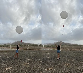
A new addition to the 2022 phase of Askos is the use of advanced drones (unmanned aerial vehicles, UAVs) and radiosondes lifted by weather balloons, each equipped with specialised sensors.
This component was run by a team of experts from the Climate and Atmosphere Research Centre (CARE-C) of the Cyprus Institute, operating from the Cesária Évora International Airport on São Vicente.
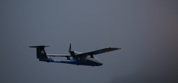
The advantage of going airborne is that measurements are made in-situ, with the drones performing calculations and collecting samples from the ground up to 5.3 km above sea level, and radiosondes reaching up to 20 km. This resulted in vertical profiles of temperature, humidity, aerosol mass concentration, particle size distributions, particle orientation and electric fields.
More than 20 radiosondes were released, and UAVs made 25 flights, 11 of which were at night. 24 dust samples were collected at different altitudes, their exact composition and properties later analysed with a Scanning Electron Microscope.
Combining measurements gives more insight
Finally, Askos coordinated with the aircraft campaigns of other JATAC teams in September 2022. NASA’s Convective Processes Experiment – Cabo Verde (CPEX-CV) and the University of Nova Gorica’s Calibration and Validation for Aeolus – Aerosols and Winds (CAVA-AW) used aircraft equipped with a suite of remote and in-situ sensors as well as dropsonde-launch capability.
NASA’s DC-8 jetliner was fitted with two lidars, radar, radiometer and dropsonde equipment to investigate tropospheric aerosols, cloud particles, winds, temperature, water vapour and precipitation to improve the understanding and predictability of tropical convective weather systems.

Next to ten aircraft flights, including four 'underflights' along the same path as Aeolus of which two were directly above the Askos ground instruments, the team released three radiosondes from the ground each day.
The Slovenian CAVA-AW Advantic WT-10 aircraft conducted nine flights with optical sensors and particle collectors to sample aerosols at different altitudes in the Saharan Air Layer. By measuring optical properties of coarse dust and fine aerosols separately, researchers hoped to determine how heating of the atmosphere by light-absorbing aerosols influences the regional climate.
The synergy of all these measurements ensures that we have a complete picture for comparison to Aeolus data, particularly in relation to aerosols, atmospheric dynamics and clouds.
This rich dataset can open new avenues for weather and climate research, including in biogeochemistry, volcanic ash and exoplanetary dust research.
Askos and other JATAC data will be made publicly available in 2023.
_________________________________
[1]This ground-based instrument measures properties of falling hydrometeors – raindrops, snow, hail or graupel – including their size distribution and the fall velocity. The data can then be translated into other atmospheric parameters like hydrometeor type, rain/snow rate or Radar reflectivity.