- All Categories (41477)
- Data (55)
- News (184)
- Missions (23)
- Events (54)
- Tools (8)
- Activities (11)
- Campaigns (18)
- Documents (41124)
DATA
Discover and download the Earth observation data you need from the broad catalogue of missions the European Space Agency operate and support.
Data - Campaigns (Open)
SARSimHT
The main objective of “SARSimHT – Airborne SAR experiment to simulate Hydroterra data” was to demonstrate the image formation process of Hydroterra through the exploitation of a repeat-pass hyper-temporal airborne SAR image stack acquired over short time intervals representative of the Hydroterra mission.
Data - Campaigns (Open)
PhotoProxy 2019
The Photosynthetic-Proxy Experiment campaign address relevant open aspects that are related to the quantitative assessment of vegetation photosynthesis and vegetation stress from space.
Data - Campaigns (Open)
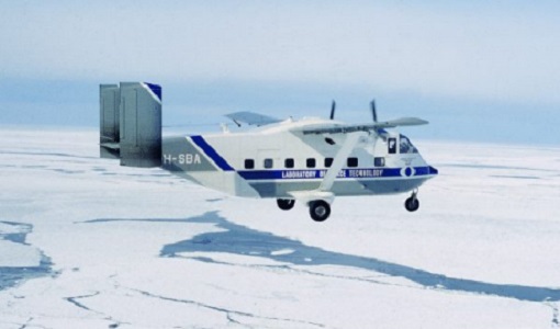
SnowLab-NG
The overall objective of the SnowLab-NG activity was to provide a comprehensive multi-frequency, multi-polarisation, multi-temporal dataset and active and passive microwave measurements over snow-covered grounds.
Data - Campaigns (Open)

AROMAT-II
This campaign covers the fields of atmospheric composition: NO2, SO2, aerosols, over Romania (Bucharest and Turceni) and Germany (Berlin).
Data - Campaigns (Open)
HydroSoil
The main objective of HydroSoil was to demonstrate the retrieval of soil moisture and vegetation parameters in an agricultural field under controlled conditions using a ground-based fully-polarimetric SAR instrument (GB-PolSAR).
Data - Campaigns (Open)
FLEXSense 2019
The FLEXSense 2019 campaign activities were undertaken in Germany and Italy with the goal of providing a complete set of high-resolution experimental data, including all relevant elements required for the preparation of the FLEX satellite mission.
Data - Campaigns (Open)

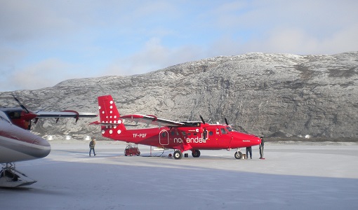
AfriSAR 2015
During the AfriSAR 2015 campaign, shared between ONERA (dry season, July 2015) and DLR (wet season 2016), Pol-InSAR and TomoSAR airborne data set were collected over four test sites over Africa, therefore covering different forest structures.
Data - Campaigns (Open)

BelSAR 2018
The BelSAR project intended to carry out an airborne campaign for SAR bistatic interferometric measurements at L-band and full polarisation, over a test site in Belgium.
Data - Campaigns (Open)

BioSAR 2007
The BioSAR campaign aimed to support geophysical algorithm development, calibration/validation and the simulation of future spaceborne Earth Observation missions.
Data - Campaigns (Open)

WISE
The objective of WInd and Salinity Experiment 2001 (WISE 2001) was to get more data points and better wind speed (WS) measurements so as to reduce the sensitivity to WS uncertainty.
Data - Campaigns (Open)

BioSAR 2008
The main objective of BioSAR-2 (BioSAR 2008) campaign was to record SAR data over boreal forests with topographic effects to investigate the effect on biomass retrieval.
Data - Campaigns (Open)

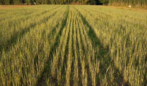
AGRISAR 2006
The AGRISAR 2006 campaign, carried out between 18 April and 2 August 2006, was established to address important specific programmatic needs of Sentinel-1 and -2.
Data - Campaigns (Open)

AgriSAR 2009
The AgriSAR 2009 campaign was defined to leverage the RADARSAT-2 mission to better understand and demonstrate the potential for GMES land monitoring user services, particularly in agriculture.
Data - Campaigns (Open)

AIRFIRE
The fires observational campaign was performed during summer 2006 and dedicated to the study of fire emission in the spectral region VNIR-SWIR.
Data - Campaigns (Open)

AquiferEx
The AquiferEx Optical and Radar Campaign was in support of information product generation based on satellite data, harmonisation of satellite data acquisition performed among Aquifer and AquiferEx project partners.
Data - Campaigns (Open)
CoSMOS 2006
ESA conducted an airborne campaign to map sea surface salinity named "CoSMOS-OS" that took place in April 2006 over the Norway Sea off the coast of Stavenger.
Data - Fast Registration with immediate access (Open)
ERS-2 GOME Total Column Amount of Trace Gases Product
GOME Level 2 products were generated by DLR on behalf of the European Space Agency, and are the end result of the Level 1 to 2 reprocessing campaign of GOME Level 1 version 4 data with Level 2 GOME Data Processor (GDP) version 5.0 (HDF-5 format). The GOME Level 2 data product comprises the product header, total column densities of ozone and nitrogen dioxide and their associated errors, cloud properties and selected geo-location information, diagnostics from the Level 1 to 2 algorithms and a small amount of statistical information.
Data - Fast Registration with immediate access (Open)
GOME Total Column Water Vapour Climate product
The GOME Total Column Water Vapour (TCWV) Climate product was generated by the Max Planck Institute for Chemistry (MPIC), and the German Aerospace Center (DLR) within the ESA GOME-Evolution project. It is a Level 3 type product containing homogenized time-series of the global distribution of TCWV spanning over more than two decades (1995-2015). The data is provided as single netCDF file, containing monthly mean TCWV (units kg/m2) with 1-degree resolution, and is based on measurements from the satellite instruments ERS-2 GOME, Envisat SCIAMACHY, and MetOp-A GOME-2. Details are available in the paper by Beirle et al, 2018. Please also consult the GOME TCWV Product Quality Readme file before using the data.
Data - Fast Registration with immediate access (Open)

Envisat GOMOS Geolocated Calibrated Transmission Spectra and Photometer Fluxes [GOM_TRA_1P]
This data product describes the geolocated and calibrated transmission spectra products, containing the full transmission and the covariance spectra needed for Level 2 processing. Coverage is as follows: Elevation range: +62 deg to +68 deg Azimuth range: +90 deg to +190 deg (with respect to the flight direction). The file size is 1 MB per occultation, depending on the duration of the occultation.
Data - Fast Registration with immediate access (Open)
Envisat GOMOS Level 2 - Atmospheric constituents profiles - User Friendly Product [GOMOS_UFP]
This data product describes atmospheric constituents profiles: In particular the vertical and line density profiles of ozone, NO2, NO3, O2, H2O, air, aerosols, temperature, turbulence. Coverage is as follows: Elevation range: +62 deg to +68 deg Azimuth range: +90 deg to +190 deg (with respect to the flight direction) The GOMOS data are now also available as user friendly products in the NetCDF4-format. These products are occultation based (dark and bright) and include all GOMOS Level 2 constituent profiles (O3, NO2, NO3, O2, H2O, air and aerosols) and HRTP profiles with all the essential parameters as in the original Envisat data set format.