- Campaigns
- SARSimHT
SARSimHT
Overview
What was the purpose of SARSimHT?
The main objective of “SARSimHT – Airborne SAR experiment to simulate Hydroterra data” was to demonstrate the image formation process of Hydroterra through the exploitation of a repeat-pass hyper-temporal airborne SAR image stack acquired over short time intervals representative of the Hydroterra mission. Hydroterra was one of three mission concepts competing for Earth Explorer 10, consisting of a geosynchronous satellite to cover Africa and the Mediterranean area with a C-band SAR for an improved understanding and prediction capability of rainfall and water availability, flooding and landslides.
SARSimHT included the development, testing and application of processing algorithms to simulate the Hydroterra image formation process, application to the airborne image stack, followed by a quantitative assessment of the image formation process and preliminary investigations of variations in scene radar observables as a function of the changing geophysical conditions.
The main objectives of SARSimHT were:
- To gain knowledge about the new SAR data processing and challenges using geosynchronous SAR satellite data
- The development, testing, implementation and application of processing algorithms to simulate the Hydroterra image formation process
- To demonstrate the image formation process of Hydroterra and specifically the hour-long integration times using airborne SAR data
- A quantitative assessment of the image formation process and image quality in the presence of disturbances arising from the long integration time (e.g. weather, vegetation and humidity effects)
- Preliminary investigation into the variations (e.g. trends, correlation) of radar observables as a function of the changing geophysical conditions through the comparison with ground-truth data
- To investigate the potential to detect diurnal changes of land surface parameters (e.g. soil moisture) with simulated Hydroterra time series
- To introduce wind effects in simulated Hydroterra data to identify and quantify to which extent defocussing of high vegetation areas affects the surrounding areas of bare soil / sparse vegetation
What was the outcome of SARSimHT?
The airborne campaign took place on 9 July 2019. During this experiment, two flights, one in the morning and the other one in the afternoon, were performed. The data were collected with DLR’s airborne radar system F-SAR.
The test site was around Kaufbeuren, a small town in Bavaria, Germany. During the SARSimHT airborne flight campaign, three teams collected ground truth data at different survey points at the test site. In total, measurements at 123 survey points were collected. The main goal of the ground truth data collection was to investigate the vegetation type and height at the test site. The day before and the day after the airborne experiment, 673 aerial views from drone flights were collected at three different areas inside the test site.
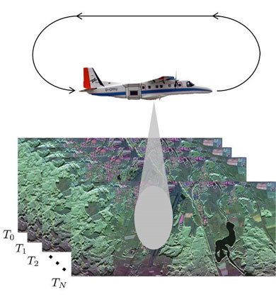
To simulate the long integration time of Hydroterra, data of the test site were repeatedly collected to acquire an image stack of 13 StripMap SAR images with zero spatial baseline and 8-9 minutes temporal baseline. This acquisition procedure was used for both flights. A simulated integration time of 1 hour and 41 minutes for the first flight and 1 hour and 44 minutes for the second flight was achieved with the described procedure.
The acquired airborne image stacks were used to demonstrate the image formation process of geosynchronous SAR data. The potential to detect diurnal moisture changes was further investigated.
Download the SARimHT Final Report
| Campaign name | SARSimHT |
| Data Coverage (Year) | 2019 |
| Release Date | August 2022 |
| Geographic Site | Germany |
| Mission Instrument | F-SAR |
| Field of Application | Understanding and prediction of rainfall and water availability, flooding and landslides |
| Data Size | 259G |
Digital Object Identifier: European Space Agency, 2019, SARSimHT – Airborne SAR experiment to simulate Hydroterra data, https://doi.org/10.5270/ESA-b192e2b
Data
The campaign data is available online via FTPS upon submission of a data access request. An active EO Sign In account is required to submit the request.
The data can be downloaded via an FTP client (e.g., FileZilla or WinSCP) using the option "Implicit FTP over TLS".
For further information about the EO Sign In Service you can visit TellUs
Should you need support please contact EOHelp