- Campaigns
- HydroSoil
HydroSoil
Overview
What was the purpose of HydroSoil?
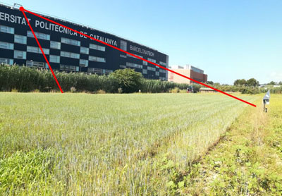
The main objective of “HydroSoil – Ground based SAR experiment for soil moisture measurements” was to demonstrate the retrieval of soil moisture and vegetation parameters in an agricultural field under controlled conditions using a ground-based fully-polarimetric SAR instrument (GB-PolSAR). The instrument simulates the frequent acquisitions of the Hydroterra mission, which was one of the candidates for ESA's 10th Earth Explorer. The desire was to have a time series as long as possible in order to sample contrasting soil moisture and vegetation conditions, such as a complete growing cycle from sowing to the harvest/senescence period.
More specifically, the main objectives of the HydroSoil campaign were:
- Acquisition of ground-based SAR data with incidence angles similar to geosynchronous satellite observations of Europe with a temporal resolution of < 15 minutes. Fully polarimetric acquisitions were to be preferred to enable simulation of any polarimetric scenario.
- Observation of an agricultural field typical for south and central Europe over a complete cultivation cycle.
- Correlative ground-based measurements including soil moisture, soil roughness, vegetation sampling, meteorological parameters and irrigation information.
- Observation of changes in backscatter due to rain showers to validate the hypothesis that frequent radar measurements can resolve processes such as interception of precipitation, evaporation of intercepted precipitation, surface soil moisture change in response to rain, run-off, etc.
- Documentation of phase changes and changes in backscatter over time and correlation to soil moisture and vegetation dynamics.
- Assessment of the HH-VV decorrelation as a function of surface parameters (i.e., crop structure, vegetation water content, soil roughness and soil moisture content).
- Assessment of the InSAR temporal decorrelation as a function of surface parameters and the temporal baseline.
- Assessment of the ability of the InSAR phase to observe crop physiology (movement of water, controlled by vegetation, in the soil and plant during the day).
What was the outcome of HydroSoil?
The HydroSoil campaign consisted of two measurement campaigns of two full crop cycles in 2020. In the first campaign season from March until June 2020, barley, a typical cereal cultivated in southern Europe, has been sown and monitored until the beginning of summer. Immediately after barley harvest, the field has been ploughed and corn has been sown. Due to the water requirements of corn, an irrigation system has been deployed. The corn crop has been monitored through its life cycle until harvesting in November 2020.
The GB-PolSAR instrument was designed and built by members of UPC’s CommSensLab Research Centre. The incidence angles have been similar to those of geosynchronous satellite observations over Europe. Special operation modes of the radar have been used in order to satisfy complementary objectives such as determining the Doppler spectrum of agricultural scenes induced by wind or assessing the defocusing due to phase decorrelation using the long synthetic aperture integration times (from several minutes to hours) that were foreseen for Hydroterra.
The assessment has required intensive procurement of ground truth ancillary data, encompassing continuous acquisition of relevant meteorological parameters like air humidity, temperature, precipitation wind speed and direction, pressure and solar irradiation. Soil roughness has been characterised after crop sowing. Several calibrated soil moisture sensors have been installed at different depths at different field locations to provide continuous monitoring of soil moisture. Frequent vegetation sampling and processing have also been performed, to obtain data on plant density, size, row direction, leaf area index (LAI), height and orientation of main elements, water cycle and water content. The different densities, sizes and water content of both crops and all data generated will allow to assess Hydroterra’s and other future missions’ capabilities to provide soil moisture and crop water content data.
Continuous monitoring of an agricultural field with a temporal resolution of 10 minutes and a spatial resolution in the order of a square meter have been completed for both measurement campaigns. This operation has resulted into a huge data set of more than 31,000 polarimetric acquisitions with 150 GB of raw radar data which are complemented with additional ancillary data. The campaigns have provided calibrated dual-pol (for barley) and quad-pol (for corn) Single Look Complex (SLC) images with a large number of resolution cells. The data will be used to investigate the capability of a GeoSAR mission concept to retrieve soil moisture and to measure vegetation parameters.
Download the Hydrosoil Final Report
| Data Coverage (Year) | 2020 |
| Release Date | July 2022 |
| Geographic Site | Spain |
| Mission Instrument | SAR (GB-PolSAR) |
| Field of Application | SAR polarimetry |
| Data Size | 130 GB |
Digital Object Identifier: European Space Agency, 2020, HydroSoil- Ground based SAR experiment for soil moisture measurements, https://doi.org/10.5270/ESA-ecac020
Data
The campaign data is available online via FTPS upon submission of a data access request. An active EO Sign In account is required to submit the request.
The data can be downloaded via an FTP client (e.g., FileZilla or WinSCP) using the option "Implicit FTP over TLS".
For further information about the EO Sign In Service you can visit TellUs
Should you need support please contact EOHelp