- GEOSAT-2
- Mission
- GEOSAT-2 Overview
GEOSAT-2 Overview
Mission Background
The Earth observation system was developed by Elecnor Deimos, who managed the engineering, ground segment, integration, tests, launch contract and LEOP, in collaboration with Satrec Initiative, who provided the platform and the payload.
The platform is based on DubaiSat-2 launched in 2013, with a larger battery pack intended to last for at least seven years.
The whole GEOSAT-2 ground segment was developed in-house by Elecnor GEOSAT based on its own gs4EO product suite, born out of the know-how acquired during more than a decade of work for the European Space Agency.
The satellite was purchased from Elecnor GEOSAT by Urthecast in 2015, together with GEOSAT-1 and GEOSAT Imaging, the division of the Spanish company that was in charge of the operation of both satellites. Now the satellites are operated by GEOSAT.
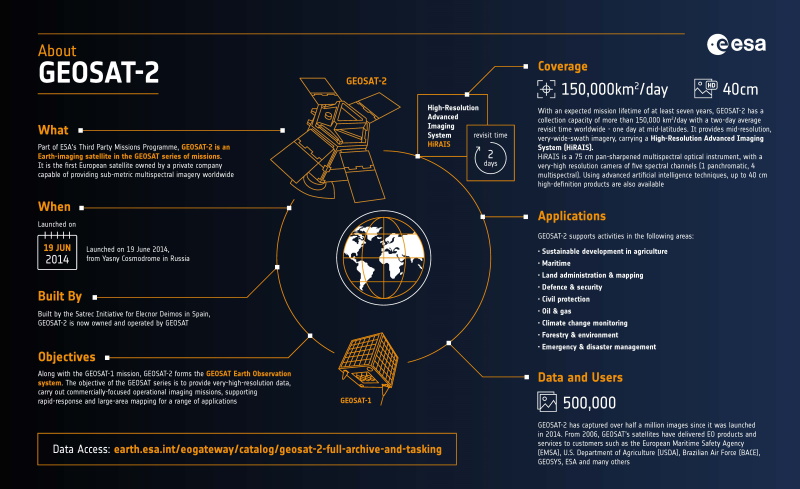
Infographic
See an overview of the GEOSAT-2 mission in this infographic:
Satellite Design
The spacecraft design is based on an agile platform for fast and precise off-nadir imaging (up to 30° over nominal scenarios and up to 45° in emergency cases), and it carries a push-broom very-high resolution camera with five spectral channels (one panchromatic, four multispectral).
The imaging payload covers a panchromatic channel (450-900nm) and four multispectral channels – Blue (420-510nm), Green (510-580nm), Red (600-720nm) and Near Infrared (760-890nm). Multispectral resolution is 4 metres and the sharpened-PAN mode achieves ground resolutions of up to 0.75 metres.
During its nominal operations, the satellite spends the majority of its sunlit orbit portion in a sun-pointing attitude to charge its batteries. In eclipse, the satellite is pointing nadir to minimise the use of payload heaters. When in Earth imaging mode, the satellite normally uses off-nadir angles of +/-30 degrees to acquire images of targets. For special targets of opportunity, off-nadir angles of up to 45 degrees are acceptable.
GEOSAT-2 can operate in single strip imaging, multi-pointing imaging of close targets, single-pass stereo imaging by along-track pitch manoeuvres. For imagery downlink, the satellite acquires an attitude to have its X-Band antenna facing the ground station and using the gimbal mechanism to track the station.
| Mass | 310 kg |
| Dimensions | 1.5 m × 1.95 m |
| Design lifetime | 7 years |
Mission Operations
GEOSAT-2 has a Sun-synchronous near-circular orbit with a nominal altitude 620 km, crossing the equator south to north at 10:30 local time.
A four day revisit time performance is enabled by the ±45° maximum off-nadir pointing capability.
The main ground station for GEOSAT-2 is Puertollano (Spain) with a 10-metre dish. The Svalbard station in Norway is used when needed.
Related links
Learn more about GEOSAT-2:
- GEOSAT-2 on the eoPortal (The information provided is sourced and updated by external entities. For further details, please consult our Terms and Conditions page.)