- Aeolus
- Mission
- Aeolus Overview
Aeolus Overview
Mission Background
The European Space Agency (ESA) wind mission, Aeolus, hosted the first space based Doppler wind lidar world-wide. The primary mission objective was to demonstrate the Doppler wind lidar technique for measuring wind profiles from space, intended for assimilation in Numerical Weather Prediction (NWP) models in Near-Real-Time (within three hours of sensing). The wind observations are also used to advance atmospheric dynamics research and for evaluation of climate models. Mission spin-off products are profiles of cloud and aerosol optical properties.
Aeolus was the fifth Earth Explorer mission to be launched. The Earth Explorers are specialised missions dedicated to observing different aspects of the planet and our environment. A secondary aim of the programme is to understand how these aspects interact with one another.
The Aeolus mission selection was motivated by the need for more abundant direct wind profile measurements in the World Meteorological Organization (WMO) Global Observing System (GOS), which is used by weather forecast models world-wide.
Currently, the global distribution of conventional wind profile measurements is not homogenous and mainly located over land in the Northern Hemisphere. Winds are also inferred from temperature soundings for the large-scale wind fields in the extra-tropics. Scatterometers provide surface winds over the oceans (single level), and Atmospheric Motion Vector (AMV) winds deduced from cloud, aerosol, humidity or ozone tracking are limited in vertical coverage and have less accurate height assignments.
The lack of homogenous wind field sampling, in particular in the tropics, over the oceans and in polar areas leads to difficulties in constraining atmospheric models and limits the studying of key processes in coupled climate systems. Aeolus winds have contributed to mitigate the current wind observation deficit. Significant weather forecast improvements has been demonstrated by a number of weather centres across the world using Aeolus observations, including the European Centre for Medium-Range Weather Forecasts (ECMWF).
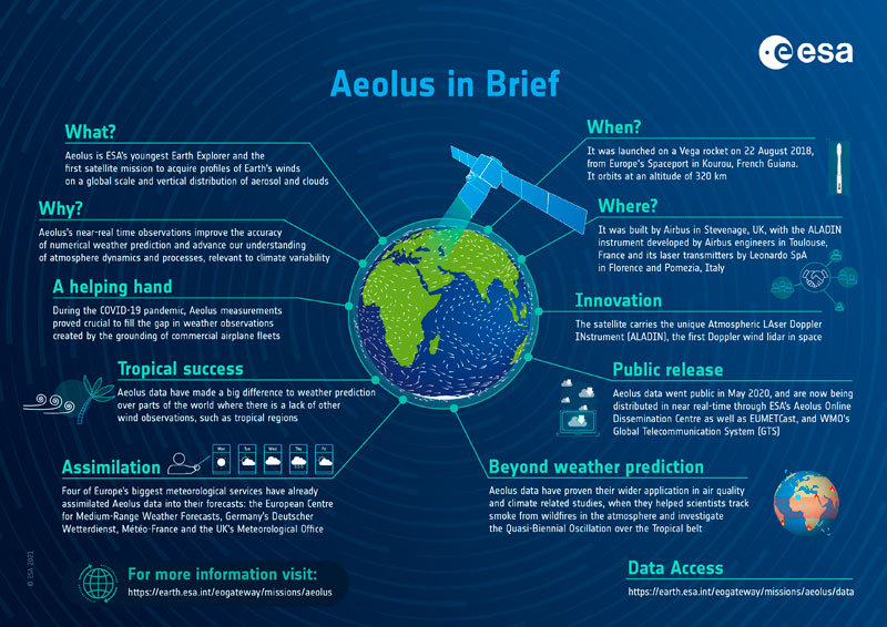
Aeolus Infographic
Learn more about the Aeolus mission in this infographic:
Satellite Design
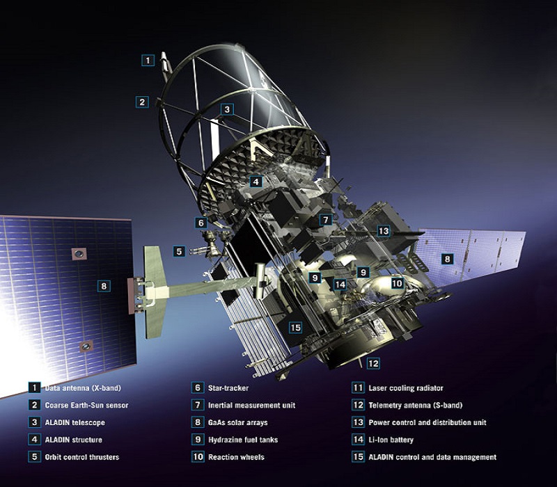
The Aeolus satellite platform structure consisted of honeycomb elements, using a conventional cubical spacecraft design, derived form the ESA mission MarsExpress. The platform was 4.6 m x 1.9 m x 2.0 m, with a total mass of 1360 kg (including 266 kg fuel).
The satellite hosted two solar arrays, mounted on each side of the platform. Each array was 13 m long, and contained three panels. The platform power came from the 2.4 kW deployable solar arrays (2 x 3 panels) with GaAs cells, and the 84 Ah Li-ion battery.
The Aeolus instrument payload, ALADIN, had a cylindrical structure including a 1.5 m diameter telescope surrounded by a baffle, and was mounted on top of the satellite platform.
Mission Operations
Today, satellite missions are designed according to regulations that require them to minimise the risk of causing damage on their return to Earth. However, when Aeolus was designed back in the late 1990s no such regulations were in place so, ESA went above and beyond for Aeolus and attempted a new way of assisting its re-entry to make it even safer.
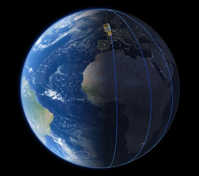
Aeolus flew in a Sun-synchronous orbit at a mean altitude of 320 km. Approximately 16 orbits were achieved per day and the satellite had a seven day repeat cycle with an orbital period of 90 minutes.
For real-time housekeeping telemetry downlink and telecommanding, the Aeolus mission used ESA's ESTRACK ground station in Kiruna. Scientific payload data acquisition was guaranteed with the combined usage of Svalbard and Troll X-band receiving stations.
Flight operations were conducted at the European Space Operations Centre (ESOC) and maintenance was performed at the European Space Research and Technology Centre (ESTEC), two ESA facilities that played an important role in the Aeolus mission.
The Payload Data Ground Segment (PDGS) was responsible for providing several core operational functions that were essential for the mission. These functions included:
- Science data acquisition
- Systematic generation of Aeolus data products in Near Real Time (NRT)
- Reprocessing
- Data preservation
- Data access
- User services
X-band data acquisition and systematic data generation activities (up to L2A product level) in NRT were delivered as part of the COSA Service (Core Operational Services for Aeolus) by KSAT/Norway.
ECMWF, the European Centre for Medium-Range Weather Forecasts, produces systematically L2B and L2C Aeolus Wind products as part of the DAMI Service (Dedicated Data Processing and Data Delivery Services for Aeolus Mission).
Related Links
- ESA Atmospheric Validation Data Centre (EVDC)
- ESA Aeolus corporate page
- ESA Aeolus videos
- Aeolus on the eoPortal (The information provided is sourced and updated by external entities. For further details, please consult our Terms and Conditions page.)