Vegetation (VGT) Overview
Design
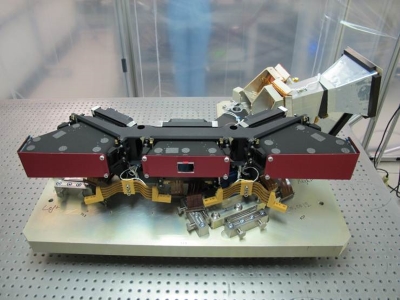
The payload consists of three identical cameras, each with a very compact Three Mirror Anastigmat (TMA) telescope. Each TMA, having a FOV of 34°, contains four spectral bands: three bands in the visible range (Blue, Red and NIR) and one band in the SWIR spectral range. The swath Total FOV is 103°. VGT-P is restricted to imaging land and dedicated calibration zones. Onboard the spacecraft, there is a land sea mask for each camera that allows the removal of pixels that contain only sea and dictates when each camera should be in imaging mode.
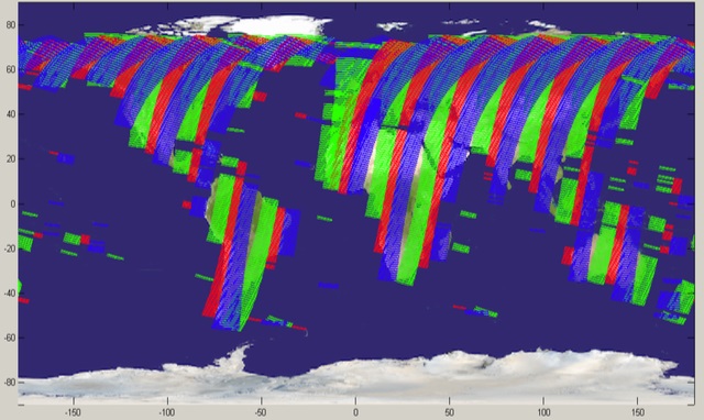
The imager's continent-spanning 2250 km field of view collected light in the blue, red, near-infrared and mid-infrared wavebands which is ideal for monitoring plant and forest growth as well as inland water bodies. Once cloud cover was accounted for, a complete composite of Earth's land cover was available to the scientific community and a significant number of operational data users every ten days.
Sensor Modes
Nominal Observation Mode
On PROBA-V, when nominal observation mode is active, the operational scenario is fully automatic and performed onboard based on a reference scenario which can be tuned by a number of configurable parameters.
The nominal scenario orbit has the following phases:
- Starting from north to south (descending part of the orbit), the satellite is in a geodetic attitude with yaw steering correction. It images areas with land coverage within specific latitude restrictions and illuminated with a minimum sun angle. During this phase, the integration time is continuously updated to optimise the instrument settings with regard to the light conditions of the imaged area.
- When -56 degrees latitude is reached (latitude of Cape Horn), the satellite stops imaging and autonomously enters in a sun-bathing mode, changing the attitude to maximize the power input from the sun. During this phase, the instrument is set into idle mode.
- When entering eclipse on the ascending part of the orbit, the satellite returns to a geodetic pointing mode.
- On the exit of eclipse, the instrument is re-activated to reach thermal stability by the time the first land areas are in visibility.
- The reaction wheel momentum off-loading is autonomously performed when the instrument is not imaging.
The momentum offloading management is de-activated 10s before the next imaging sequence to give some time for the platform to stabilise its attitude. - This cycle repeats itself autonomously without the need for commands from the ground.
The above approach allows the activation of continuous acquisitions of all scientifically interesting parts of the Earth (land defined in the land-sea mask), with a single telecommand, which is the command to enter nominal observation mode. It activates the required units, commands the correct attitude, enables the autonomous instrument operations and runs the reference scenario continuously.
Calibration Mode
The mission Principal Investigator (PI) has the possibility to request specific calibration activities. These are crucial for maintaining the quality of the scientific data and for correcting for instrument degradation. On average three specific calibrations are executed every day, they include acquisition over specific ocean sites for Rayleigh, Deep Convective Clouds and Sun glint calibration, while desert site calibration is part of nominal acquisition. To limit the load on the Mission Operations Centre for these regular activities, these calibration activities are also automated.
In calibration mode, firstly the required off-pointing is commanded (if any), followed by the reconfiguration of the instrument. For calibration activities, typically, different instrument settings are required compared to nominal observations. This is not limited to instrument settings only, but can also include changes in the compression ratios of the science data (some calibrations require uncompressed data for example).
A special calibration request is the moon calibration. As this is not a zone on Earth and the calibration is executed once every 28 days based on a specific moon phase angle, the handling of this request is slightly different from the other calibration requests. The moon requests have a separate onboard queue and the required maneuver is calculated on the ground due to the sporadic nature of the request.
Mission Operations
A timeline providing the main PROBA-V mission operations events:
- Launch and Early Operations Phase (7 - 17 May 2013):
The PROBA-V satellite was launched on Tuesday 7 May 2013 at 02:06 UTC in Kourou (French Guyana) on a Vega launch vehicle. PROBA-V was deployed into its Sun-synchronous near-polar orbit at 820 km altitude, just 55 minutes after launch. First raw image from the PROBA-V sensor was successfully acquired over France's west coast on 15 May 2013. Analysis of the first image quality confirmed that the sensor was in good health and ready for the commissioning phase. - Commissioning Phase (17 May 2013 - 3 December 2013):
After the launch and initial in-flight verification phase, the six months Commissioning of the satellite started, where payloads and systems were gradually activated and their performance validated. This included a careful cross-calibration of the Vegetation imager with the previous generation of the instrument, operating on France's SPOT-5 satellite, to ensure data compatibility. Radiometric and geometric calibration was also executed. Following the successful completion of the Commissioning Phase the satellite began its nominal operations lifetime. - Operations Phase (3 December 2013 to 30 June 2020):
The nominal Operations Phase started after the Commissioning of the satellite with a nominal lifetime of 2.5 years (with potential extension up to a total of five years). The satellite exceeded both its nominal lifetime and extension, ending operations almost seven years after the nominal phase began.
Main Mission News
The milestones in the mission are listed below. Additional news and mission information are both available on the dedicated ESA page.
- Long-live PROBA-V (November 2021)
The end of VEGETATION instrument operations is, however, not the end of PROBA-V's life: the other instruments on board are fully functional and will continue to send data to the Redu ground station. In particular, the Energetic Particle Telescope instrument provides near real time and static radiation data products for the SSA Space Weather Service Network. - PROBA-V, ready to close its green eyes (October 2021)
While the operational mission of the global PROBA-V mission ended on 30 June 2020 after more than seven years in orbit, its vegetation instrument continued acquiring data over the European and African land masses in an experimental mode. - New experimental phase for PROBA-V (August 2020)
After more than seven years in space - and despite the satellite still being in excellent condition - ESA's PROBA-V mission ended operations on 30 June 2020. But the vegetation mission continues in a new experimental phase. - PROBA-V Collection 1 dataset reprocessing completed (February 2017):
The PROBA-V re-processing campaign, using the latest Processor was completed. The new Collection 1 or C1 dataset included significant quality improvements with respect to previous data version Collection 0 (C0): re-fined radiometric calibration parameters, metadata compliancy to Climate and Forecasting convention (v1.6), and a Cloud Detection Algorithm. In addition, the intermediate L2A products were made available with this reprocessing.
The C1 dataset was identified by the version number "V101", replacing the old "V001" used previously. - Release of PROBA-V L2A products to users (February 2017):
The intermediate PROBA-V Level-2A (L2A) Top-of-Atmosphere products were made available with the release of the PROBA-V Collection 1 (C1) reprocessed dataset. The Level-2A product contains radiometrically and geometrically corrected TOA reflectance values, projected to a Plate Carrée grid. The L2A products were provided per band/camera. - Release of GeoTiff products to users (September 2015):
In order to facilitate the use of PROBA-V data, all of the products were made available in both GeoTiff and HDF5 format. GeoTiff is a worldwide raster metadata standard that allows for embedding georeferencing information and is supported by most GIS software packages, such as Quantum GIS, ArcGIS, ERDAS IMAGINE, and ENVI. As for HDF5, also in GeoTiff, separate PROBA-V data could be stitched into a single file during ordering. - Release of PROBA-V 100 m to users (March 2015):
PROBA-V 100 m measurements of the central camera (500 km swath, 5 days revisit time) were made available to the users as 1 day and 5 days synthesis products, both TOA and TOC reflectances are provided to the users. - Hand-over from SPOT-VGT to PROBA-V (31 May 2014):
The SPOT Vegetation mission, flown on the SPOT 4 and SPOT 5 satellites, marked 16 years of service in May. The last SPOT-VGT mission was officially ended on 31 May 2014. As of 1 June 2014, PROBA-V was the official SPOT-VGT successor mission, mapping land cover and vegetation growth across the entire planet every two days. The one year of overlap allowed to perform a careful cross-calibration between the two sensors, ensuring a consistent time series for scientists to employ seamlessly.