Etna Volcano - Italy, 2001
Etna, Italy, 21 July 2001 - Lava crawls towards Etna village Nicolosi, Sicily - Thick rivers of lava crawled down the sides of Mount Etna towards a village as Europe's most active volcano rumbled for a third straight day. Five fissures have now opened up in the mountain on the Mediterranean island of Sicily and flowing lava has reached to within 5 km of Nicolosi. The lava has moved more than 1 km in the past three days but on Saturday had slowed to about five metres an hour from more than twenty on Thursday and Friday.
Living in shadow of a volcano, July 25, 2001 - Lava exploding from Mount Etna is providing a spectacular sight for residents of nearby towns every night. The volcano on the Italian island of Sicily has been increasingly active during the past week, spewing lava, ash and rock from several fissures. Rivers of lava have flowed down Mount Etna, threatening nearby villages despite thousands of tons of water being dropped by air to try to cool the advancing lava. The eruption has caused $3.1 million in damage, including losses in tourism and agriculture, the local government said.
Mount Etna, towering above Catania, Sicily's second largest city, has one of the world's longest documented records of historical volcanism. Historical lava flows cover much of the surface of this massive basaltic stratovolcano, Italy's highest and most voluminous volcano. The Mongibello stratovolcano, truncated by several small calderas, was constructed during the late Pleistocene and Holocene over an older shield volcano. The most prominent morphological feature of Etna is the Valle del Bove, a 5 x 10 km horseshoe-shaped caldera open to the east.
Two styles of eruptive activity typically occur at Etna. Persistent explosive eruptions, sometimes with minor lava emissions, take place from one or more of the three prominent summit craters, the Central Crater, NE Crater, and SE Crater (the latter formed in 1978). Flank vents, typically with higher effusion rates, produce eruptions from fissures that open progressively downward from near the summit (usually accompanied by strombolian eruptions at the upper end). Cinder cones are commonly constructed over the vents of lower flank lava flows. Lava flows extend to the foot of the volcano on all sides and have reached the sea over a broad area on the SE flank.
|
Event Timeline |
|
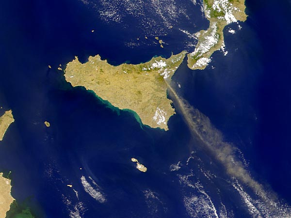
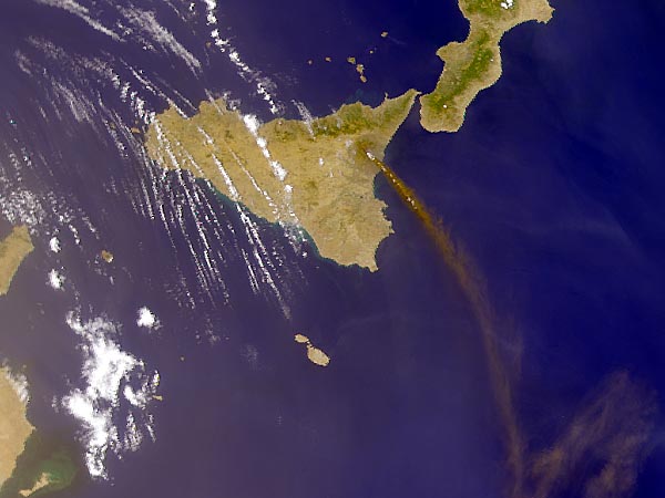
ERS-2 ATSR instrument images |
|
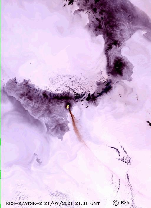
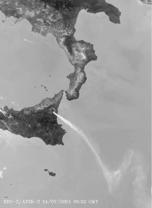
These two images show the volcano between 21 and 24 July 2001. These daytime images are a false colour combination of the 11 micron e 1.6 micron channels which highlight the extent of the plume of the volcano. |
|
21 July 2001 |
|
Technical Information |
|
Satellite: |
Envisat |
|
Instrument: |
ATSR |
|
Channels: |
11 micron e 1.6 micron |
|
Date of Acquisition: |
21 - 24 July 2001 |
|
Micron channel images |
This image was taken at night, which is made from two infrared channels:
-
3.7 micron channel
-
11 micron channel
The 3.7 micron channel distinctly shows the extremely high temperature of the lava. |
|
This image was taken on 24 July 2001, which shows in detail the infrared 11 micron channel. The difference of temperature between the smoke and the sea is clearly visible in this image. Interestingly, the smoke is cooler than the sea – much like the vapour trails that follow a jet aircraft. |
|
LandSat images |
|
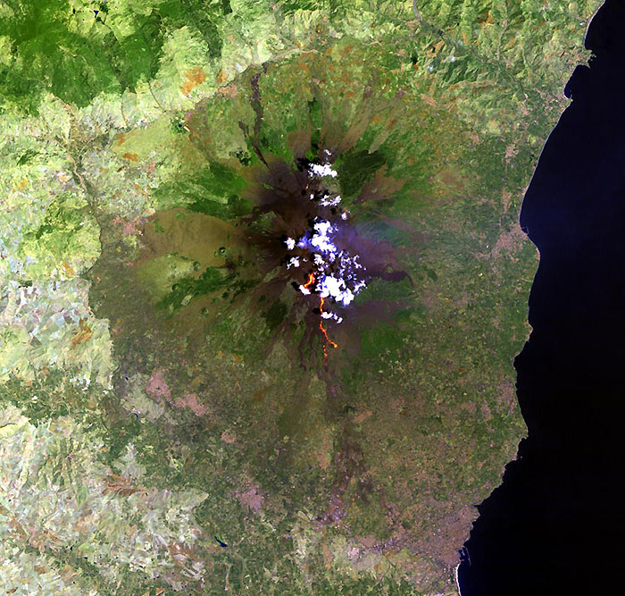
This Landsat 5 TM image shows the volcano activity on 21 July 2001. The bright puffy clouds were formed from water vapour released during the eruption. |
|
LandSat 5 TM images |
|
Landsat-5 TM image acquired on 06 August 2001. |
|
Technical Information |
|
Satellite: |
LandSat TM/ETM+ |
|
Band Combination |
752 |
|
Date of Acquisition: |
21 July - 06 August 2001 |
|
This Landsat 7 ETM+ image shows the volcano on 13 July 2001 where it is possible to see the outflow of lava and the plume of generated smoke. |
|
LandSat 7 ETM+ images |
|
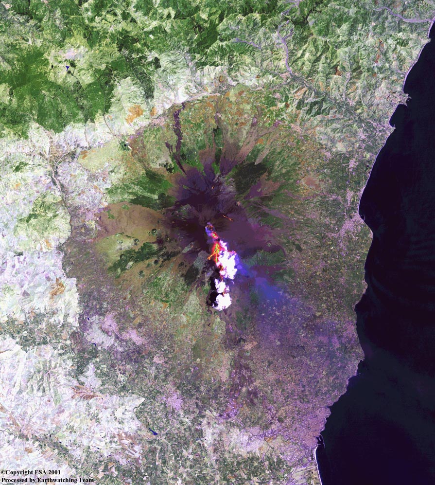
This Landsat 7 ETM+ image shows the activity of the volcano on 29 July 2001. A new outflow of lava is visible (the bright white areas are small clouds above the volcanic crater, partially due to the heat of the volcano). |
|
Landsat 7 ETM+ image acquired on 05 August 2001 (night-time image). |
|
Technical Information |
|
Satellite: |
LandSat TM/ETM+ |
|
Band Combination |
752 |
|
Date of Acquisition: |
13, 29 July - 05 August 2001 |
|
SeaWiFS satellite images - Copyright NASA and Orbimage (research and education only) |
|
Mt. Etna is currently venting white steam clouds. This SeaWiFS image shows the plume drifting towards the southeast and then southward along the eastern edge of the island. |
|
13 July 2001 |
|
Mt. Etna can be seen contributing a slender plume, larger than in the previous image |
|
19 July 2001 |
|
SeaWiFS captured an image of a yellowish-brown plume emanating from Mt. Etna volcano, stretching over 600 km south-eastward across the Mediterranean towards Libya. |
|
22 July 2001 |
|
The smoke plume is more evident |
|
24 July 2001 |
|
A plume of steam or ash is still visible from Mt. Etna; the plume is mingling with aerosols from other sources such as Sahara and Europe. |
|
27 July 2001 |
|
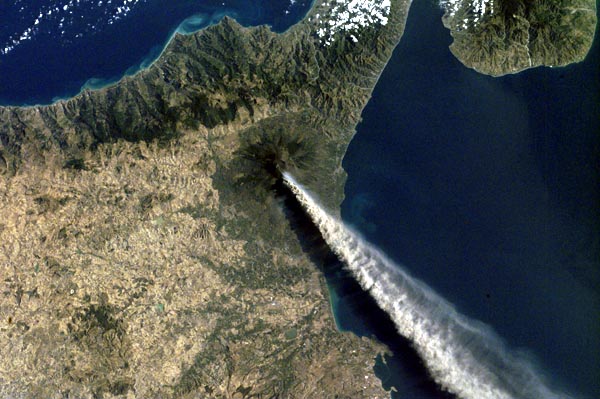
TERRA satellite and International Space Station images - Copyright NASA |
|
This ASTER image shows advancing lava flows on the southern flank of Mt. Etna above the town of Nicolosi, which is potentially threatened if the eruption increases in magnitude. Also visible are glowing summit craters above the main lava flows, and a small fissure eruption. |
|
29 July 2001 |
|
NASA's MODIS captured this true-colour image of the volcano. The eruption has opened five vents in the mountain, and is releasing a cloud of ash that can be seen stretching south-eastward over the Mediterranean Sea. The current eruption includes an explosive fissure along the south flank of the mountain, and lava is creeping its way toward the town of Nicolosi. |
|
22 July 2001 |
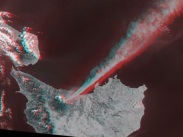
These MISR images show the eruption of the Mt. Etna volcano. At the bottom of this image set are true-colour views;
-
forward
-
nadir
-
backward-viewing camera
This image is a stereo anaglyph created from two forward views. Two plumes of differing compositions are seen to be emanating from Etna. The bright, brownish plume drifting southeast (the images are West up) is composed primarily of tiny frozen fragments of lava. A fainter, bluish-white plume is also visible, especially near the summit, and is most apparent in the forward view. It contains very fine droplets of dilute sulphuric acid. |
|
3D (three-dimensional) image |
|
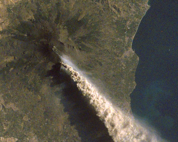
When this photograph was taken by the crew aboard the International Space Station, the city of Catania was covered by a layer of ash and its Airport was closed. On that day an ash cloud was reported to have reached a maximum height of ~5.2 km. Two types of plumes are visible from these photos; a dense and darker mass plume (of the three summit craters) and a lighter yet lower plume. |
|
Magnified view of Mt. Etna |
|
TERRA Instruments abbreviations |
-
ASTER - Advanced Spaceborne Thermal Emission and Reflection Radiometer
-
MISR - Multi-angle Imaging Spectro Radiometer
-
MODIS - Moderate-resolution Imaging Spectro-radiometer
|
|
|