Berlin, 12 April 2006 (From AFP) - More than 3,000 volunteers in the district of Luechow-Dannenberg, south-east of Hamburg, worked through the night to reinforce the leaking dykes along the swollen Elbe River. At the confluence of the Elbe and Jeetzel rivers, the medieval city of Hitzacker whose old town is under water reported some relief.
"The flooding is sinking about one centimetre every two hours" - A spokesperson for Luechow-Dannenberg said, noting that a quickly erected retaining wall had sunk the level of the Jeetzel by 50cm, also easing the pressure on the dykes in nearby Dannenberg. She said authorities hoped most of Hitzacker's old town would be dry by Friday.
The government of the eastern state of Saxony, upriver on the Elbe where the flooding began in Germany, agreed to an initial €20 million package to fund low-interest loans for homeowners and companies hit by the flooding. An additional €10 million was earmarked for dyke repair.
The level of the Danube between Passau and the nearby city of Kelheim remained lower than expected, although it was not expected to peak until Thursday afternoon. The town of Landshut on the Isar River was expecting record water levels following highs set in the region in 1999.
The Elbe flooded parts of Saxony earlier this month as snow melted at the beginning of spring. It rose to more than three times its normal level before receding. The historic state capital of Dresden, whose prized Baroque and Rococo buildings were badly hit by flood waters in 2002, escaped damage this time.
|
Event Timeline |
|
ERS-2 SAR Satellite images |
|
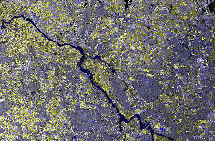
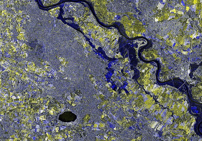
These multi-temporal images have been composed using two date acquisitions:
|
|
The images were acquired before and after the flooding event covering the flood extent around the Elbe River.
|
|
Elbe River - Hitzacker, Lower Saxony, Germany
|
|
Elbe River – Saxony-Anhalt, Germany
|
|
Technical Information |
|
Satellite: |
ERS-2 |
|
Instrument: |
Synthetic Aperture Radar (ASAR) |
|
Instrument Features: |
25 meter resolution |
|
Date of Acquisition: |
(Red): 7 April 2006
(Green): 7 April 2006
(Blue): 1 July 2005 |
|
Orbits: |
57326, 53318 |
|
Frames: |
1071, 1053 |
 Flood - Elbe River (Germany), April 2006