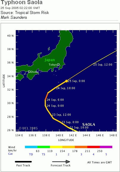
TOKYO, Sept 25 (From AFP) - A strong typhoon bore down on islands south of the Japanese capital on Saturday, bringing strong winds and whipping up high waves along the country's Pacific coast, the meteorology agency said. Typhoon Saola, named after the Vietnamese for a forest-dwelling ox, was about 680 kilometers south of Tokyo around 0400 GMT, packing winds of up to 144 kilometers per hour. It was heading north in the Pacific at 15 kilometers per hour Saturday and was forecast to pass near an island chain south of the capital the following day. The meteorological agency warned of rainfall of up to 250 millimeters by early Sunday for the Izu chain of islands. The storm was expected to take a turn eastward before reaching Japan's mainland of Honshu. The agency issued warnings against thunder storms, violent winds and high waves to areas along the Pacific coast. Japan has been hit by a series of typhoons this year. Typhoon Nabi left 27 people dead or missing as it criss-crossed Japan earlier this month. It injured 140 people and flooded nearly 10,000 homes. Nabi also left at least five people missing in South Korea.
|
Envisat view of Typhoon Saola |
This Medium Resolution Imaging Spectrometer (MERIS) Level 1 image shows Typhoon Saola (centre lower image), located south of Tokyo over Honshu Island. The coastlines have been highlighted in red to define their locations.
Back to top
 Typhoon Saola (Japan) - September 2005