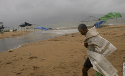
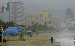
EL PASO, Texas, 04 September 2006 (From AP) - Heavy rain flooded roads in the Southwest on Monday as the rapidly weakening remnants of Hurricane John spread across the border from Mexico, where up to 20 inches had fallen on parts of the Baja Peninsula. A half-mile section of Interstate 10 near downtown El Paso was closed by water Monday morning, police spokesman Javier Sambrano said. Normally dry southern New Mexico got enough rain to cause isolated road flooding, southern Arizona had scattered rain, and showers were possible in desert areas of southern California through Tuesday, the U.S. National Hurricane Center said. In the El Paso area, where almost 3 inches of rain had fallen since Friday, no injuries or evacuations were reported, unlike during storms about a month ago that washed out roads and chased people out of their homes. Sambrano said. "We've been very fortunate because it's actually been nonstop rain throughout the night." Carlsbad, New Mexico, had curb-to-curb water on the streets from three days of rain, but a police dispatcher said no streets were closed Monday. Heavy rain on Sunday shut down the 8th annual Harvest Wine Festival in Las Cruces, New Mexico, the first time the festival had been rained out, organizers said. The Las Cruces airport reported more than 2 inches of rain in 3 hours Sunday. John was a Category 2 hurricane with sustained wind of 110 mph when it struck near the southern tip of Baja on Friday, but officials reported only minor damage. The area hardest hit was La Paz, the capital of Baja California del Sur state. "Fortunately there is no human loss and the impact (in terms of damage) is relatively modest," Mexican President Vicente Fox said Sunday as he toured the city and pledged to help residents whose homes had been damaged. By early Monday, the storm's maximum sustained wind had slowed to about 30 mph, well below the 39 mph threshold for a tropical storm, as it slowly moved northwestward up the spine of the narrow Baja Peninsula.
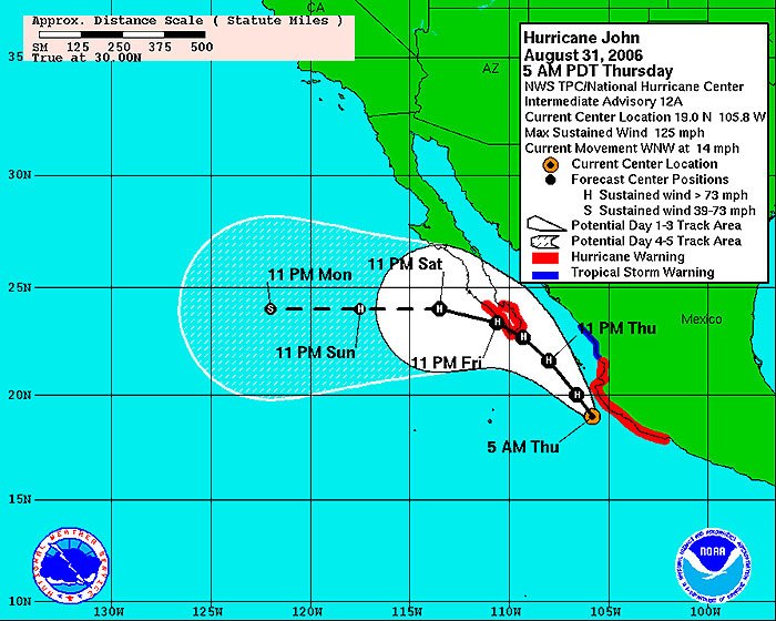
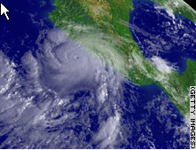
CABO SAN LUCAS, Mexico, September 1, 2006 (From CNN) - Government officials ordered the evacuation of 15,000 people from low-lying areas on the Baja California peninsula Thursday as Hurricane John approached, the state governor's office said. Officials said residents would be evacuated from low-lying areas by force if necessary, and hotels were sending foreign tourists home, Reuters reported. John already has caused heavy flooding on Mexico's mainland between the popular tourist destination of Acapulco and the city of Manzanillo to the northwest. The Mexican government warned residents along the coast to "rush to completion" protective measures for Hurricane John, as a hurricane warning was issued for the area from Cabo Corrientes to San Blas, northwest of Guadalajara. Islas Marias was included. In its 11 p.m. ET advisory, the U.S. National Hurricane Center said the storm was about 90 miles west of Las Islas Marias about 170 miles southeast of the southern tip of Baja California. "Preparations to protect life and property in these areas should have already been completed," the National Hurricane Center said, quoting the government. Hurricane John was downgraded from a Category 3 storm to Category 2 Thursday afternoon, when its top winds weakened from 125 mph to 105. According to the Saffir-Simpson scale of hurricane intensity, Category 2 storms have top sustained winds between 96 and 110 mph and can cause some damage to buildings and trees. A hurricane warning remained in effect for the southern Baja peninsula from San Everisto southward on the east coast and from Bahia Magdalena southward on the west coast. A tropical storm warning remained in effect from San Blas to Mazatlan on the mainland coast. Another tropical storm warning was issued for the central Baja peninsula. A hurricane warning means hurricane conditions are expected within the warning area within 24 hours; a tropical storm warning means tropical storm conditions are expected within 24 hours. In the fishing mecca of Cabo San Lucas, at the tip of Baja California, authorities said they were preparing shelters for the possible evacuation of 30,000 people. All flights from that area to the United States were nearly sold out, officials said. The storm was moving to the northwest at near 13 mph, a motion that was expected to continue for at least 24 hours. The center will move near or over southern Baja California on Friday with little change in strength, forecasters said. Hurricane-force winds extended outward up to 25 miles from John's center. Tropical storm-force winds extended outward up to 105 miles. Rainfall amounts of 6 to 10 inches, with isolated totals up to 18 inches, were possible along the western coast of Mexico within the warning areas. These amounts could cause life-threatening flash floods and mudslides over areas of mountainous terrain, the hurricane center said. Coastal storm surge flooding of up to 5 feet above normal tide levels along with large and dangerous battering waves can be expected on the shores near the path of the center of the hurricane, it said. John is the 10th named storm of the season in the eastern Pacific. Storms in the eastern Pacific are named separately from those in the Atlantic, the central Pacific or the western Pacific. Last October, Hurricane Wilma pounded Mexico's Yucatan Peninsula with 125 mph winds and heavy rains. The Category 3 storm dealt a heavy blow to the tourism industry in Cancun, Cozumel and Playa de Carmen. Meanwhile, Tropical Storm Ernesto's maximum sustained winds were at 70 mph, just 4 mph short of Category 1 hurricane strength, as it made landfall in North Carolina late Thursday.
|
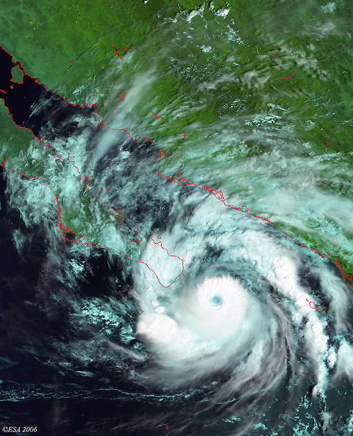
Envisat views of Hurricane John |
This Medium Resolution Imaging Spectrometer (MERIS) image is the latest to be acquired along the south coasts of Baja California. The image shows Hurricane John (lower right) as it approached the coast. The coastlines have been highlighted in red to define their location.
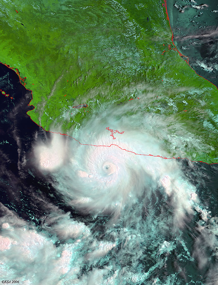
This Medium Resolution Imaging Spectrometer (MERIS) image was acquired along Mexico's coast, where Hurricane John was striking the area. The coastlines have been highlighted in red to define their location.
Back to top
 Hurricane John (Mexico) - September 2006