 Asset Publisher
Lisbon, Portugal08 August 2014 - Lisbon, the capital city of Portugal, is featured in this Landsat comparison. Acquired 27 years apart, these Landsat 5 and 8 images show how Lisbon has developed since 1987. 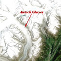
Thinning ice on the Aletsch Glacier30 July 2014 - Thinning ice on the Aletsch Glacier in the Alps can be seen in this comparison between the Landsat 5 and Landsat 8 satellites. Separated by 27 years, the images highlight how the glacier has changed since 1987. 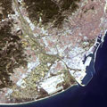
Barcelona, Spain24 July 2014 - The Spanish city of Barcelona is featured in this Landsat 5 and Landsat 8 comparison. Acquired 27 years apart, the images demonstrate urban development and change from 1987 to 2014. 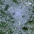
Bastille Day - Paris, France18 July 2014 - Bastille Day is a national holiday in France which takes place every year on 14 July. It celebrates the historic capture of the Bastille in Paris, an important event of the French Revolution. This Landsat 5 and 8 image comparison shows Paris in 1985 and 2014 and commemorates the day. 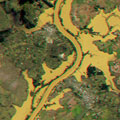
Flooding in Brazil - June-July 201411 July 2014 - These Landsat 8 images, acquired 05 July 2014, show a large area of flooding near Sao Borja city, in Rio Grande do Sul, Brazil. The southern Brazilian state has been affected by floods since late June 2014, which forced 6,000 people to evacuate. 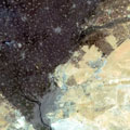
Cairo, Egypt07 July 2014 - The capital city of Egypt, Cairo, can be seen in this image comparison between the Landsat 5 and Landsat 8 satellites. Acquired thirty years apart, the images highlight urban change and development in the city and surrounding area. 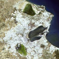
Tunis, Tunisia01 July 2014 - Tunis, the capital city of Tunisia, is the focus of this Landsat comparison. Seen by the Landsat 5 and Landsat 8 satellites 27 years apart, the images demonstrate urban change and development in the city since 1987. 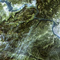
Three Gorges Dam, China27 June 2014 - The Three Gorges Dam, in China, can be seen in this Landsat 5 and Landsat 8 image comparison. Acquired 27 years apart, they demonstrate the development of the dam on the Yangtze River. 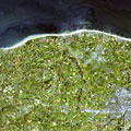
Seine Bay, Normandy - 70 years after D-Day19 June 2014 - This Landsat 8 image, acquired in 2013, shows the Seine Bay, where 70 years ago the D-Day invasion on the coast of Normandy began. It was one of the most significant points in the Second World War and is remembered every year on 06 June. 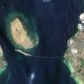
Copenhagen, Denmark12 June 2014 - Copenhagen, the capital city of Denmark, can be seen in this latest Landsat comparison. Acquired 25 years apart these images show how the city, and particularly the Øresund Bridge, has developed since 1988. 
Nicosia, Cyprus30 May 2014 - Nicosia, the capital city of Cyprus, is featured in this Landsat 5 and Landsat 8 comparison. Acquired 30 years apart, the images show urban development in the city. 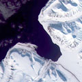
Svalbard, Norway08 May 2014 - The Svalbard archipelago, in Norway, can be seen in this Landsat 8 image, acquired 03 May 2014. Svalbard is the northernmost permanently inhabited location in the world. 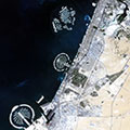
Dubai, United Arab Emirates24 April 2014 - This Landsat 5 and Landsat 8 image comparison shows the city of Dubai in the United Arab Emirates. It highlights the development of the Palm Islands along the coast and the growth of the city between 1987 and 2013. 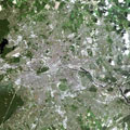
Berlin, Germany10 April 2014 - Urban change in Berlin, the capital of Germany, can be seen in these images acquired by the Landsat 5 and Landsat 8 satellites, from 1989 and 2013. 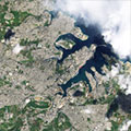
Valletta, Malta03 April 2014 - These Landsat-5 and Landsat-8 images were acquired over Malta, in 1987 and 2014, and show how the infrastructure of the capital city, Valletta, has changed. 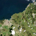
Tangier, Morocco21 March 2014 - The city of Tangier in Morocco and the Gibraltar Straits can be seen in these Landsat-5 and Landsat-8 images, from 1985 and 2014. 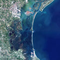
Venice, Italy07 March 2014 - These Landsat 5 and Landsat 8 images provide a comparison of the MOSE Project in Venice, Italy, between 1985 and 2013; which aims to protect Venice from flooding. 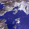
Athens, Greece27 February 2014 - This Landsat 8 image, acquired on 11 January 2014, shows the Saronic Gulf which is home to the city of Athens, the capital of Greece. 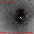
Mount Etna VolcanoThese Landsat 8 images show Mount Etna volcano, that lit up the sky with huge bursts of lava in its largest eruption in December 2013. Its last major eruption occurred in 1992. 
Cinque Terre - Ligurian RivieraThis Landsat 8 image, acquired in August 2013, shows the Ligurian coast of Italy, also known as the Cinque Terre ("Five Lands" in Italian). 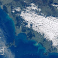
Tuscan ArchipelagoThis image, acquired in the month of January 2014 by the Landsat 8 satellite, shows the Tuscan Archipelago off the west coast of Italy. |
||