 Warsaw, Poland
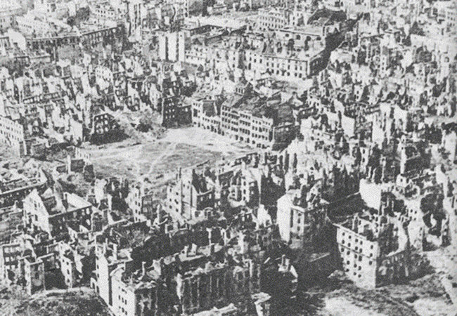
Warsaw is the capital and largest city of Poland. It is located on the Vistula River, in east-central Poland, roughly 260 kilometres from the Baltic Sea and 300 kilometres from the Carpathian Mountains. Its population is estimated at 1.729 million residents within a greater metropolitan area of 2.666 million residents, which makes Warsaw the 9th most populous capital city in the European Union. The area of the city covers 516.9 square kilometres, while the city's agglomeration covers 6,100.43 square kilometres. In 2012 Warsaw was ranked as the 32nd most liveable city in the world by the Economist Intelligence Unit. It was also ranked as one of the most liveable cities in Central and Eastern Europe. Today Warsaw is considered an Alpha– global city, a major international tourist destination and a significant cultural, political and economic hub. Warsaw's economy, by a wide variety of industries, is characterised by FMCG manufacturing, metal processing, steel and electronic manufacturing and food processing. The city is a significant centre of research and development, BPO, ITO, as well as Polish media industry. The Warsaw Stock Exchange is one of the largest and most important in Central Europe. Frontex, the European Union agency for external border security, is headquartered in Warsaw. A unique feature of Warsaw is its number of skyscrapers and high-rise buildings in the city centre which form the skyline. Warsaw is one of only a few cities in the European Union that have such a skyline, together with Frankfurt, London and Paris. The first historical reference to Warsaw dates back to the year 1313, when initially Kraków served as the Polish capital city. Due to its central location between the Commonwealth's capitals of Kraków and Vilnius, Warsaw became the capital of the Commonwealth and the Crown of the Kingdom of Poland when King Sigismund III Vasa moved his court from Kraków to Warsaw in 1596. After the Third Partition of Poland in 1795, Warsaw was incorporated into the Kingdom of Prussia. In 1806 during the Napoleonic Wars, the city became the official capital of the Grand Duchy of Warsaw, a puppet state of the First French Empire created by Napoleon Bonaparte. With accordance to the decision of the Congress of Vienna, Warsaw in 1815 was annexed by the Russian Empire and became part of the "Congress Kingdom". In 1918 it regained independence from foreign rule and emerged as a new capital of the independent Republic of Poland. Along with the German invasion in 1939, the massacre of the Jewish population and deportations to concentration camps led to the uprising in the Warsaw ghetto in 1943 and to a major and devastating Warsaw Uprising between August and October 1944. For this Warsaw gained the title of the "phoenix city" because it has survived so many wars, conflicts and invasions throughout its long history. Most notably, the city had to be painstakingly rebuilt after the extensive damage it suffered in World War II, during which 85% of its buildings were destroyed. On 9 November 1940 the city was awarded Poland's highest military decoration for heroism, the Virtuti Militari, during the Siege of Warsaw (1939). The city is the seat of a Roman Catholic archdiocese (left bank) and diocese (right bank of the Vistula), and possesses various universities, most notably the Polish Academy of Sciences and the Warsaw University, an opera house, theatres, museums, libraries and monuments. The historic city centre of Warsaw with its picturesque Old Town in 1980 was listed as a UNESCO World Heritage Site. Other main architectural attractions include the Castle Square with the Royal Castle and the iconic King Sigismund's Column, St. John's Cathedral, Market Square, palaces, churches and mansions all displaying a richness of colour and architectural detail. Buildings are representatives of nearly every European architectural style and historical period. Warsaw has wonderful examples of architecture from the gothic, renaissance, baroque and neoclassical periods and around a quarter of the city is filled with grand parks and royal gardens. More information is available on Wikipedia
Today we feature Warsaw, the largest city and capital of Poland. It is the capital of Mazowieckie Province and at the centre of rail and road networks that connect it with all parts of Poland and with other major European cities. Warsaw lies in east-central Poland about 300 km from the Carpathian Mountains and about 260 km from the Baltic Sea, 523 km east of Berlin, Germany. The city straddles the Vistula River. It is located in the heartland of the Masovian Plain, and its average elevation is 100 metres above sea level. Although 90 per cent of the industry of Warsaw was destroyed in World War II, the rebuilt industrial region of the city has numerous enterprises. The principal industries are printing, publishing, and the manufacture of motor vehicles, electronic products, steel and other metals, textiles, non-electrical machinery, motorcycles, chemicals, tobacco products, processed food, and furniture. The aim of these images, acquired by the Landsat 5 and 8 satellites with an acquisition time window (before / after) of twenty four years, is to show the urban development from 1990 until today. In the image acquired in 2014 we can see the urban development changes that have occurred during the intervening years. Another aim of these images is to promote the opportunity to download Landsat data through the ESA portals, where images captured every day are made available in near real time to the users and the scientific community. Landsat full resolution data products are freely available for immediate download at: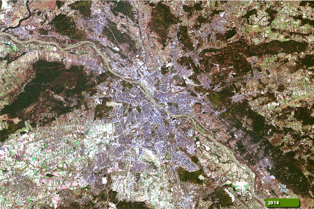 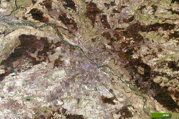 View Landsat 5 TM high resolution image (JPG 1.7 MB) View Landsat 8 OLI high resolution image (JPG 1.7 MB)
|
|||||||||||||||||||||