 Trieste, Italy
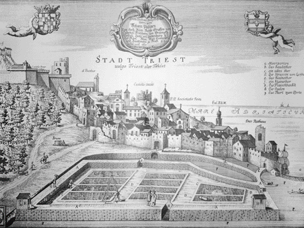
Trieste is a city and seaport in north eastern Italy. It is situated towards the end of a narrow strip of Italian territory lying between the Adriatic Sea and Slovenia, which lies almost immediately south and east of the city. Trieste is located at the head of the Gulf of Trieste and throughout history it has been influenced by its location at the crossroads of Latin, Slavic, and Germanic cultures. In 2009, it had a population of about 205,000 and it is the capital of the autonomous region Friuli-Venezia Giulia and the Province of Trieste. The free port was maintained (as of the Free Port of Trieste) in the Treaty of Paris between Italy and the Allied Powers in 1947 by which was established the Free Territory of Trieste, and in 1954 the Allied Military Government gave the civil administration to Italy by virtue of the Memorandum of London. Today it is a hub for international trade flows between the land-sea markets of Central and Eastern Europe and Asia. Trieste was one of the oldest parts of the Habsburg Monarchy. In the 19th century, it was the most important port of one of the Great Powers of Europe. As a prosperous seaport in the Mediterranean region, Trieste became the fourth largest city of the Austro-Hungarian Empire (after Vienna, Budapest, and Prague). In the fin-de-siecle period, it emerged as an important hub for literature and music. It underwent an economic revival during the 1930s, and Trieste was an important spot in the struggle between the Eastern and Western blocs after the Second World War. Today, the city is in one of the richest regions of Italy, and has been a great centre for shipping, through its port (Port of Trieste), shipbuilding and financial services. More information is available on Wikipedia
Today we feature Trieste; a city and port in north-eastern Italy, capital of Trieste Province and of Friuli-Venezia Giulia Region, on the Gulf of Trieste, at the north-eastern extremity of the Adriatic Sea. These two images captured by the Landsat 5 and Landsat 8 satellites with a time window (before / after) of 30 years, aim to show changes in the urban area of the city and along the coast during this temporal time window. Another aim of these images is to promote the opportunity to download Landsat data through the ESA portals, where images captured every day are made available in near real time to the users and the scientific community. Landsat full resolution data products are freely available for immediate download at: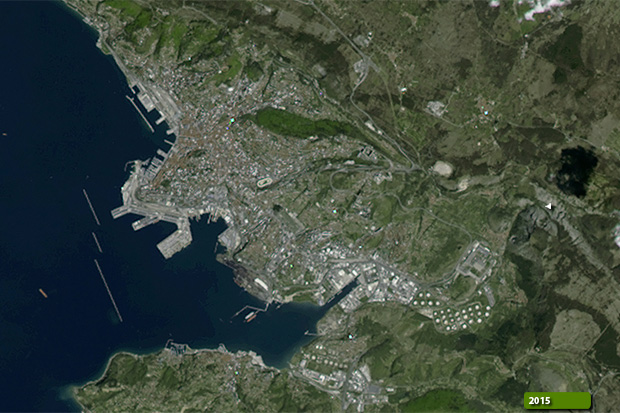 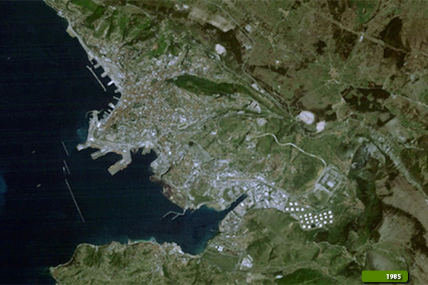
View large format slider View Landsat 8 OLI high resolution image (JPG 320 KB)
|
|||||||||||||||||||||