 Toulouse, France
Toulouse is the capital city of the southwestern French department of Haute-Garonne, as well as of the Midi-Pyrénées region. It lies on the banks of the River Garonne, 150 kilometres from the Mediterranean Sea, 230 km from the Atlantic Ocean, and 680 km from Paris. With 1,250,251 inhabitants at the January 2011 census, the Toulouse metropolitan area is the fourth-largest in France, after Paris (12.3 million), Lyon (2.2 million), and Marseille (1.7 million). Toulouse is the centre of the European aerospace industry, with the headquarters of Airbus, the Galileo positioning system, the SPOT satellite system, the Airbus Group (former EADS), ATR and the Aerospace Valley. The city also hosts the European headquarters of Intel and CNES's Toulouse Space Centre (CST), the largest space centre in Europe. Thales Alenia Space, and Astrium Satellites, Airbus Group's satellite system subsidiary, also have a significant presence in Toulouse. Its world-renowned university is one of the oldest in Europe (founded in 1229) and, with more than 103,000 students, is the fourth-largest university campus of France after Paris, Lyon and Lille. The air route between Toulouse Blagnac and Paris Orly is the busiest in Europe, transporting 2.4 million passengers in 2014. According to the rankings of L'Express and Challenges, Toulouse is the most dynamic French city. The city was the capital of the Visigothic Kingdom in the 5th century and the capital of the province of Languedoc in the late Middle Ages and early modern period (provinces were abolished during the French Revolution), making it the unofficial capital of the cultural region of Occitania (Southern France). It is now the capital of the Midi-Pyrénées region, the largest region in metropolitan France. A city with unique architecture made of pinkish terracotta bricks, which earned it the nickname la Ville Rose ("the Pink City"), Toulouse counts two UNESCO World Heritage sites, the Canal du Midi (designated in 1996 and shared with other cities), and the Basilica of St. Sernin, the largest remaining Romanesque building in Europe, designated in 1998 because of its significance to the Santiago de Compostela pilgrimage route. More information is available on Wikipedia
Today our Landsat comparison is focused over the city of Toulouse. This city is located in southern France, capital of Haute-Garonne Department, on the Garonne River and the Canal du Midi. It is a major commercial, transport, and manufacturing centre. Toulouse is noted for the production of aircraft and aerospace equipment. Other products include chemicals, clothing, electrical machinery, and farm implements. These images acquired with a temporal window of twenty-eight years (before/after), show the city during this time has had a large increase of urban development specially to the west side of the city (see the area around the airport). Another aim of these images is to promote the opportunity to download Landsat data through the ESA portals, where images captured every day are made available in near real time to the users and the scientific community. Landsat full resolution data products are freely available for immediate download at: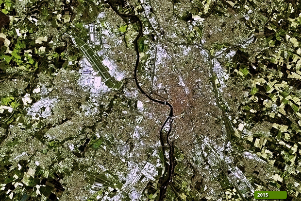 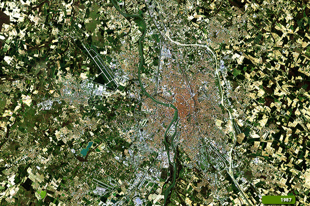 View Landsat 5 TM high resolution image (JPG 3.4 MB) View Landsat 8 OLI high resolution image (JPG 3 MB)
|
|||||||||||||||||||||