 Thessaloniki, Greece
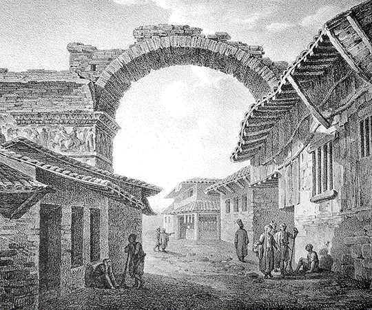
Thessaloniki is the second-largest city in Greece and the capital of Greek Macedonia, the administrative region of Central Macedonia and the Decentralized Administration of Macedonia and Thrace. The municipality of Thessaloniki, the historical centre, had a population of 385,406 in 2007, while the Thessaloniki Urban Area had a population of 800,764. and the Thessaloniki Metropolitan Area had 1,104,460 inhabitants in 2011. Thessaloniki is Greece's second major economic, industrial, commercial and political centre, and a major transportation hub for the rest of southeastern Europe; its commercial port is also of great importance for Greece and the southeastern European hinterland. The city is renowned for its festivals, events and vibrant cultural life in general, and is considered to be Greece's cultural capital. Events such as the Thessaloniki International Trade Fair and the Thessaloniki International Film Festival are held annually, while the city also hosts the largest bi-annual meeting of the Greek diaspora. Thessaloniki was the 2014 European Youth Capital. The city of Thessaloniki was founded in 315 BC by Cassander of Macedon. An important metropolis by the Roman period, Thessaloniki was the second largest and wealthiest city of the Byzantine Empire. It was conquered by the Ottomans in 1430, and passed from the Ottoman Empire to modern Greece on 8 November 1912. Thessaloniki is home to numerous notable Byzantine monuments, including the Paleochristian and Byzantine monuments of Thessaloniki, a UNESCO World Heritage Site, as well as several Roman, Ottoman and Sephardic Jewish structures. The city's main university, Aristotle University, is the largest in Greece and the Balkans. Thessaloniki is a popular tourist destination in Greece. For 2013, National Geographic Magazine included Thessaloniki in its top tourist destinations worldwide, while in 2014 Financial Times FDI magazine (Foreign Direct Investments) declared Thessaloniki as the best mid-sized European city of the future for human capital and lifestyle. Among street photographers, the center of Thessaloniki is also considered the most popular destination for street photography in Greece. More information is available on Wikipedia
Today our Landsat image comparison is focused over the city of Salonica or Thessaloníki, in north-eastern Greece, it is one of the largest cities in the country, and the chief port and commercial centre of Central Macedonia. The city is the capital of Salonica department, at the northern end of the Thermaic Gulf. Key industries in the city include iron foundries, shipyards, and textile and flour mills; major exports are mineral ores and tobacco. The city is also the seat of the Aristotle University of Salonica (1925). In the 1st century AD, the apostle Paul preached to the Thessalonians in Salonica, then in the Roman province of Macedonia. The city was occupied in the 10th century by the Saracens and in the 12th century by the Normans. In the 13th century Salonica became part of the Byzantine Empire; many fine examples of Byzantine art survive in the city, particularly the mosaics in some of its historic churches, including the basilica of Hagia Sophia and the church of St George. Salonica was under Turkish occupation from 1430 to 1912, when it surrendered to a Greek army. George I of Greece was assassinated here in 1913. The city was occupied by the Germans in World War II. Early Christian and Byzantine monuments of Salonica were inscribed on the UNESCO World Heritage list in 1988. These images acquired with a temporal window of thirty-two years (before/after), demonstrate that the city has experienced a large increase of urban development, especially along the border of the central city and to the south east where the national airport is located. We can see new tracks built along the coast and in part with a platform on the sea. Another aim of these images is to promote the opportunity to download Landsat data through the ESA portals, where images captured every day are made available in near real time to the users and the scientific community. Landsat full resolution data products are freely available for immediate download at: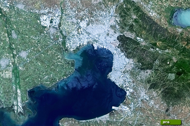  View Landsat 5 TM high resolution image (JPG 1 MB) View Landsat 8 OLI high resolution image (JPG 1 MB)
|
|||||||||||||||||||||