 Tallinn, Estonia
Tallinn is the capital and largest city of Estonia. Tallinn occupies an area of 159.2 km2 and has a population of 438,569. It is situated on the northern coast of the country, on the shore of the Gulf of Finland, 80 km south of Helsinki, east of Stockholm and west of Saint Petersburg. Tallinn's Old Town is listed as a UNESCO World Heritage Site. It is ranked as a global city and has been listed among the top 10 digital cities in the world. The city was a European Capital of Culture for 2011, along with Turku in Finland. The city was known as Reval from the 13th century until 1918 and again during the Nazi occupation of Estonia from 1941 to 1944. Approximately 32% of Estonia's total population lives in Tallinn. Tallinn is situated on the southern coast of the Gulf of Finland, in north-western Estonia. The largest lake in Tallinn is Lake Ülemiste (9.44 km2). It is the main source of the city's drinking water. Lake Harku is the second largest lake within the borders of Tallinn and its area is 1.6 square kilometres. Tallinn does not lie on a major river. The only significant river in Tallinn is Pirita River in Pirita, a city district counted as a suburb. Historically, the small Härjapea River flowed from Lake Ülemiste through the town into the sea, but the river was diverted for sewage in the 1930s and has since completely disappeared from the cityscape. References to it still remain in the street names Jõe (from Jõgi, river) and Kivisilla (from Kivisild, stone bridge). A limestone cliff runs through the city. It can be seen at Toompea, Lasnamäe and Astangu. However, Toompea is not a part of the cliff, but a separate hill. The highest point in Tallinn, at 64 metres above sea level, is situated in Hiiu, Nõmme District, in the south-west of the city. The length of the coast is 46 kilometres. It comprises three bigger peninsulas: Kopli peninsula, Paljassaare peninsula and Kakumäe peninsula. More information is available on Wikipedia
Today our tour stops over the city of Tallinn. Located on a bay off the Gulf of Finland, Tallinn is an important Baltic seaport with a large fishing industry and a naval station. The city has three distinct sections that reflect its historical evolution. Shown here is the medieval section, built in the 14th to 16th centuries, which overlooks factories along the port in the new district. The historic centre of Tallinn was designated a UNESCO World Heritage Site in 1997. It is a major Baltic port and naval station, and an important industrial centre. Industries here produce machinery, electrical equipment, ships, textiles, furniture, and canned fish. The city consists of three sections: an upper town on a steep hill topped by a citadel (13th-14th century), a lower walled town built during medieval times (14th-16th century), and a new district. Tallinn is the home of the Estonian Academy of Sciences and a polytechnic college and has several theatres, a symphony orchestra, and an opera company. In 1991, Estonia broke away from the Soviet Union and again became an independent republic. The city's historic trade ties to Scandinavia and western Europe have since helped Estonia lead the Baltic countries' transition to market-driven economies. In relation to that, these images, acquired by the Landsat 5 and 8 satellites with an acquisition time window (before / after) of thirty-one years, aim to show the urban difference before the end of the Soviet Union until today. As we see in the overlay of the images, differences of urban areas are visible around the centre of the city and also along the coasts, especially on the north-east coast. Another aim of these images is to promote the opportunity to download Landsat data through the ESA portals, where images captured every day are made available in near real time to the users and the scientific community. Landsat full resolution data products are freely available for immediate download at: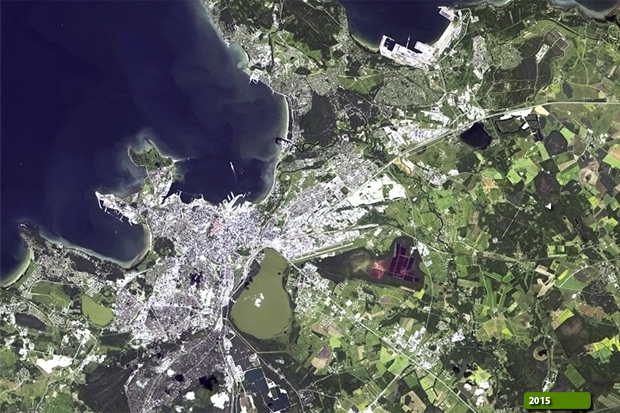 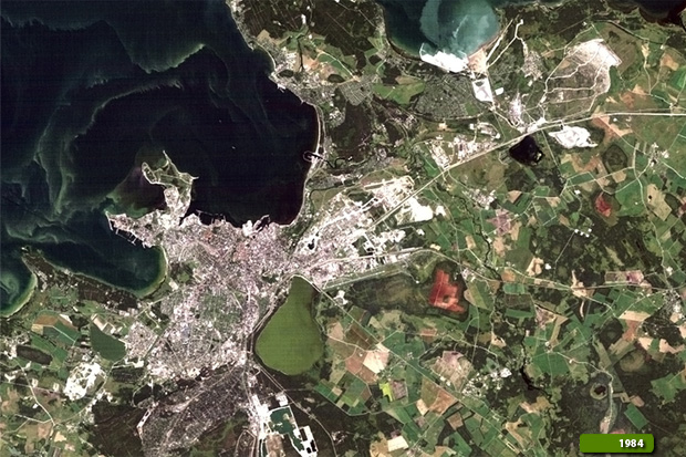 View Landsat 5 TM high resolution image (JPG 863 KB) View Landsat 8 OLI high resolution image (JPG 814 KB)
|
|||||||||||||||||||||