 Split, Croatia
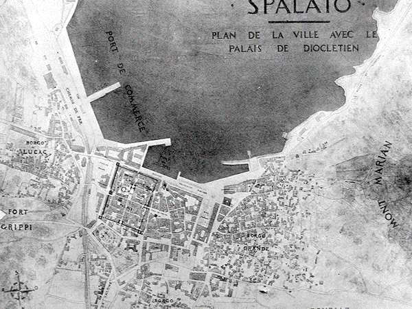
Split is the second largest city of Croatia and the largest city of the region of Dalmatia. It lies on the eastern shore of the Adriatic Sea, centred on the Roman Palace of the Emperor Diocletian. Spread over a central peninsula and its surroundings, Split's greater area includes the neighboring seaside towns as well. An intraregional transport hub and popular tourist destination, the city is a link to numerous Adriatic islands and the Apennine peninsula. Split is one of the oldest cities in the area. While it is traditionally considered just over 1,700 years old counting from the construction of Diocletian's Palace in 305 CE, archaeological research relating to the original founding of the city as the Greek colony of Aspálathos in the 4th century BCE establishes the urban history of the area as being several centuries older. The city turned into a prominent settlement around 650 AD, when it became successor to the ancient capital of the Roman province of Dalmatia, Salona: as after the Sack of Salona by the Avars and Slavs, the fortified Palace of Diocletian was settled by the Roman refugees. Split became a Byzantine city, to later gradually drift into the sphere of the Byzantine vassal, the Republic of Venice, and the Croatian Kingdom, with the Byzantines retaining nominal suzerainty. For much of the High and Late Middle Ages, Split enjoyed autonomy as a free city, caught in the middle of a struggle between Venice and the king of Hungary for control over the Dalmatian cities. Venice eventually prevailed and during the early modern period Split remained a Venetian city, a heavily fortified outpost surrounded by Ottoman territory. Eventually, its hinterland was won from the Ottomans in the Morean War of 1699, and in 1796, as Venice fell to Napoleon, the Treaty of Campo Formio rendered the city to the Habsburg Monarchy. In 1805, the Peace of Pressburg added it to the Napoleonic Kingdom of Italy, and in 1809, after the Treaty of Schönbrunn, it was included directly in the French Empire, as part of the Illyrian Provinces. After Napoleon's defeat in 1814, it was eventually granted to the Austrian Empire, where the city remained a part of the Austrian Kingdom of Dalmatia until the fall of Austria-Hungary in 1918 and the formation of Yugoslavia. During World War II, the city was annexed by Italy, then liberated by the Partisans after the Italian capitulation in 1943. It was then re-occupied by Germany, which granted it to its puppet Independent State of Croatia. The city was liberated again by the Partisans in 1944, and was included in the post-war Federal Yugoslavia, as part of its republic of Croatia. In 1991 Croatia seceded from Yugoslavia amid the Croatian War of Independence. More information is available on Wikipedia
Today we feature the city of Split. Located in southern Croatia, Split is a seaport on the Dalmatian coast of the Adriatic Sea. High mountains lie to the north and east of the city. Olive oil, fruit, and wine are exported. The principal manufactured products have included chemicals, plastics, and cement. These images, acquired by the Landsat 5 and 8 satellites with an acquisition time window (before / after) of thirty years, aim to show the urban development from 1985 until today. In the image acquired in 2015 we can see the urban development changes that have occurred during the intervening years and also the large increase of urban changes along the coast from Split to Trogir. Another aim of these images is to promote the opportunity to download Landsat data through the ESA portals, where images captured every day are made available in near real time to the users and the scientific community. Landsat full resolution data products are freely available for immediate download at: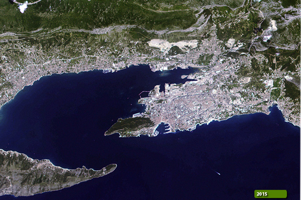 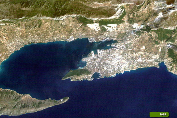 View Landsat 5 TM high resolution image (JPG 483 KB) View Landsat 8 OLI high resolution image (JPG 573 KB)
|
|||||||||||||||||||||