 Seoul, South Korea
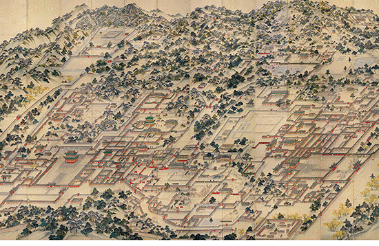
Seoul, officially the Seoul Special Metropolitan City, is the capital and largest metropolis of the Republic of Korea (commonly known as South Korea). Seoul is the world's 16th largest city, and forms the heart of the Seoul Capital Area, which includes the surrounding Incheon metropolis and Gyeonggi province. The Seoul Capital Area houses about half of the country's population of 51.44 million people with 678,102 international residents. Situated on the Han River, Seoul's history stretches back more than two thousand years when it was founded in 18 BC by Baekje, one of the Three Kingdoms of Korea. It continued as the capital of Korea under the Joseon Dynasty. The Seoul Capital Area contains five UNESCO World Heritage Sites: Changdeok Palace, Hwaseong Fortress, Jongmyo Shrine, Namhansanseong and the Royal Tombs of the Joseon Dynasty. Seoul is surrounded by mountains, the tallest being Mt. Bukhan, the world's most visited national park per square foot. Modern landmarks include the iconic N Seoul Tower, the gold-clad 63 Building, the neofuturistic Dongdaemun Design Plaza, Lotte World, the world's largest indoor theme park, Moonlight Rainbow Fountain, the world's longest bridge fountain and the Sevit Floating Islands. The birthplace of K-pop and the Korean Wave, Seoul received over 10 million international visitors in 2014, making it the world's 9th most visited city and 4th largest earner in tourism. Today, Seoul is considered a leading and rising global city, resulting from an economic boom called the Miracle on the Han River, which transformed it to the world's 4th largest metropolitan economy with a GDP of US$845.9 billion in 2014 after Tokyo, New York City and Los Angeles. In 2015, it was rated Asia's most livable city with the second highest quality of life globally by Arcadis. A world leading technology hub centered on Gangnam and Digital Media City, the Seoul Capital Area boasts 15 Fortune Global 500 companies such as Samsung, one of the world's largest technology companies, as well as LG and Hyundai-Kia. In 2014, the city's GDP per capita (PPP) of $39,786 was comparable to that of France and Finland. Ranked sixth in the Global Power City Index and Global Financial Centres Index, the metropolis exerts a major influence in global affairs as one of the five leading hosts of global conferences. Seoul is the world's most wired city and ranked first in technology readiness by PwC's Cities of Opportunity report. It is served by the KTX high-speed rail and the Seoul Subway, providing 4G LTE, WiFi and DMB inside subway cars as well as wifi at every station. Seoul is connected via AREX to Incheon International Airport, rated the world's best airport nine years in a row (2005–2013) by Airports Council International. Lotte World Tower, a 556-metre supertall skyscraper with 123 floors, has been built in Seoul and become the OECD's tallest in 2016, with the world's tallest art gallery. Its Lotte Cinema houses the world's largest cinema screen. Seoul's COEX Mall is the world's largest underground shopping mall. Seoul hosted the 1986 Asian Games, 1988 Summer Olympics, 2002 FIFA World Cup, the Miss Universe 1980 pageant, and the 2010 G-20 Seoul summit. A UNESCO City of Design, Seoul was named the 2010 World Design Capital. More information is available on Wikipedia
This week our tour around the world stops over the city of Seoul, capital of South Korea, on the Han River near the Yellow Sea port of Inch'ǒn. Situated near North Korea, Seoul is the largest city and the commercial, manufacturing, and cultural centre of South Korea. Industrial plants produce textiles, clothing, chemicals, processed food, electrical and electronic equipment, machinery, and printed materials. Government activities and tourism are also important to the city's economy. Among the leading institutions of higher education in Seoul are Korea University (1905), Seoul National University (1946), Chung-ang University (1918), Sung Kyun Kwan University (1938), Ewha Women's University (1886), and Yonsei University (1885). Other landmarks include the National Museum, featuring collections of Korean art and artefacts; the National Science Museum; Gyungbok, Kyungbok, Changdok, and Duksoo palaces; a Roman Catholic cathedral; and zoological and botanical gardens. Of special interest are the bell tower, which contains a large bronze bell inscribed with the date 1468, and the remains of the ancient stone wall that once encircled the city. In these images acquired from the Landsat 4 TM & 8 OLI satellites, we aim to show in this time window of 26 years (before - after) the areas that have changed since 1989. The major development of new buildings along the west part along the Han River is visible. Notable also in the image acquired in 2017, is the new area created for the the International and Intercontinental Airport of Seul-Incheon, one of the largest and busiest airports in the world. The Airport is located west of Incheon's city centre, on an artificially created piece of land between Yeongjong and Yongyu Islands. The two islands were originally separated by shallow sea. That area between the two islands was reclaimed for the construction project, effectively connecting the once separate Yeongjong and Yongyu islands. The reclaimed area as well as the two islands are all part of Jung-gu, an administrative district of Incheon.The airport is connected to the mainland, through the construction of Expressway well visible in the recent image. Another aim of these images is to promote the opportunity to download Landsat data through the ESA portals, where images captured every day are made available in near real time to the users and the scientific community. Landsat full resolution data products are freely available for immediate download at: 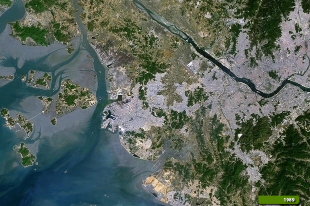 View Landsat 4 TM high resolution image (JPG 8.5 MB) View Landsat 8 OLI high resolution image (JPG 9.7 MB)
|
|||||||||||||||||||||