 Prague, Czech Republic
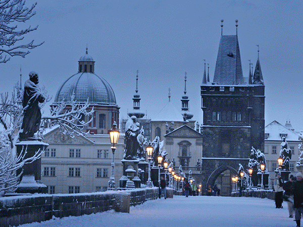
Prague is the capital and largest city of the Czech Republic. It is the fourteenth-largest city in the European Union. It is also the historical capital of Bohemia. Situated in the north-west of the country on the Vltava River, the city is home to about 1.24 million people, while its larger urban zone is estimated to have a population of nearly 2 million. The city has a temperate climate, with warm summers and chilly winters. Prague has been a political, cultural, and economic centre of central Europe with waxing and waning fortunes during its 1,100-year existence. Founded during the Romanesque and flourishing by the Gothic and Renaissance eras, Prague was not only the capital of the Czech state, but also the seat of two Holy Roman Emperors and thus also the capital of the Holy Roman Empire. It was an important city to the Habsburg Monarchy and its Austro-Hungarian Empire and after World War I became the capital of Czechoslovakia. The city played major roles in the Protestant Reformation, the Thirty Years' War, and in 20th-century history, during both World Wars and the post-war Communist era. Prague is home to a number of famous cultural attractions, many of which survived the violence and destruction of 20th-century Europe. Main attractions include the Prague Castle, the Charles Bridge, Old Town Square, the Jewish Quarter, the Lennon Wall and Petrín hill. Since 1992, the extensive historic centre of Prague has been included in the UNESCO list of World Heritage Sites. The city boasts more than ten major museums, along with numerous theatres, galleries, cinemas, and other historical exhibits. A modern public transportation system connects the city. Also, it is home to a wide range of public and private schools, including Charles University (Univerzita Karlova v Praze). Prague is classified as an "Alpha" global city according to GaWC studies, comparable to Vienna, Seoul and Washington, D.C. Its rich history makes it a popular tourist destination, and the city receives more than 4.4 million international visitors annually, as of 2011. Prague is one of the most visited European city after London, Paris, Rome, Barcelona, Istanbul, Dublin, Bucharest and Amsterdam. More information is available on Wikipedia
Today we feature the city of Prague. Located in the central-western part of the Czech Republic, it is the centre of the historical region of Bohemia and is divided by the Vltava river. The Vtlava is also joined by another river in Prague, the Berounka, which joins with the Vtlava in the Lahovice district. Among other large cities nearby are Brno, the second city of the republic; Dresden and Nuremberg in Germany; Linz in Austria; and Wroclaw in Poland. The city of Prague is spread over nine hills: Letná, Vítkov, Opyš, Větrov, Skalka, Emauzy, Vyšehrad, Karlov and finally the highest, the Petřín. These images acquired by the Landsat 5 and 8 satellites have a time window of acquisition (before / after) of thirty years and aim to show the urban difference from 1985 until today. In fact the two images show how the areas around the city have experienced large growths in urban development during this period. Another noticeable indication of growth is the airport (centre left in this image), which has changed since 1985. Another aim of these images is to promote the opportunity to download Landsat data through the ESA portals, where images captured every day are made available in near real time to the users and the scientific community. Landsat full resolution data products are freely available for immediate download at: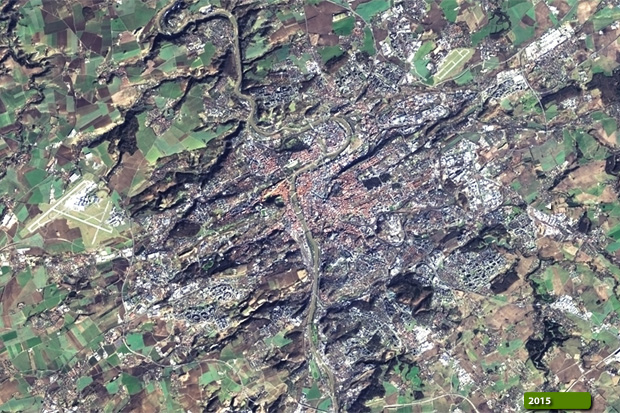 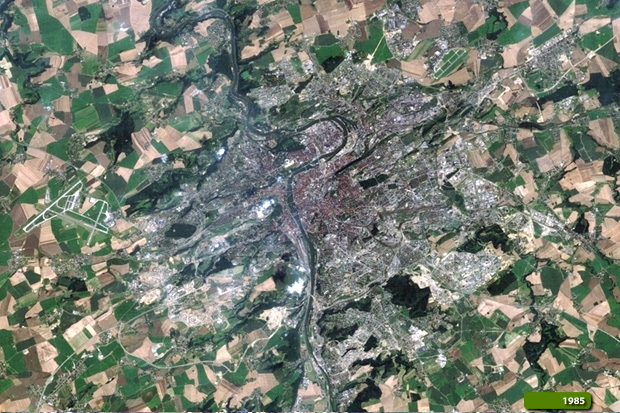 View Landsat 5 TM high resolution image (JPG 1.1 MB) View Landsat 8 OLI high resolution image (JPG 1.2 MB)
|
|||||||||||||||||||||