 Nice, France
Nice or Nissa, is the fifth most populous city in France and the capital of the Alpes Maritimes département. The urban area of Nice extends beyond the administrative city limits, with a population of about 1 million on an area of 721 km2. Located in the Côte d'Azur area on the south east coast of France on the Mediterranean Sea, Nice is the second-largest French city on the Mediterranean coast and the second-largest city in the Provence-Alpes-Côte d'Azur region after Marseille. Nice is about 13 km from the principality of Monaco, and its airport is a gateway to the principality as well. The city is called Nice la Belle (Nissa La Bella in Niçard), which means Nice the Beautiful, which is also the title of the unofficial anthem of Nice, written by Menica Rondelly in 1912. The area of today's Nice contains Terra Amata, an archaeological site which displays evidence of a very early use of fire. Around 350 BC, Greeks of Marseille founded a permanent settlement and called it Nikaia, after Nike, the goddess of victory. Through the ages, the town has changed hands many times. Its strategic location and port significantly contributed to its maritime strength. For centuries it was a dominion of Savoy, and was then part of France between 1792 and 1815, when it was returned to Piedmont-Sardinia until its reannexation by France in 1860. The natural beauty of the Nice area and its mild Mediterranean climate came to the attention of the English upper classes in the second half of the 18th century, when an increasing number of aristocratic families took to spending their winter there. The city's main seaside promenade, the Promenade des Anglais ("Walkway of the English') owes its name to visitors to the resort. For decades now, the picturesque Nicean surroundings have attracted not only those in search of relaxation, but also those seeking inspiration. The clear air and soft light have particularly appealed to some of Western culture's most outstanding painters, such as Marc Chagall, Henri Matisse, Niki de Saint Phalle and Arman. Their work is commemorated in many of the city's museums, including Musée Marc Chagall, Musée Matisse and Musée des Beaux-Arts. Nice has the second largest hotel capacity in the country and it is one of its most visited cities, receiving 4 million tourists every year. It also has the third busiest airport in France, after the two main Parisian ones. It is the historical capital city of the County of Nice (Comté de Nice). Source information from Wikipedia

Today our demostration of images taken by the Sentinel-1 (Radar7 SAR instrument) and Sentinel-2 (optical sensor), satellites of the Copernicus project family stops over the city of Nice. This city is located in south-east France, and is capital of the Alpes-Maritimes Department, on the Mediterranean Sea at the foot of the Maritime Alps. Nice has an active commercial port and a variety of manufacturing industries. The chief resort of the French Riviera, Nice is built around a bay, and its old and new districts are separated by a small stream, the Paillon. Embankments and promenades, including the celebrated Promenade des Anglais, line the seafront, and a boulevard extends along the bay shore. The city and bay are sheltered from severe climatic changes by the mountains in the north. Nice is also a cultural centre, with its own university (1965) and several museums, including two devoted to works of the 20th-century artists Henri Matisse and Marc Chagall. It is the site of Roman ruins and of the 17th-century monastery of Cimiez. In these images, we can see the Nice Côte d'Azur Airport. This international airport is located 5.9 km southwest of Nice, in the Alpes-Maritimes départment of France. It is the third busiest airport in France and serves as a focus city for Air France and an operating base for easyJet. 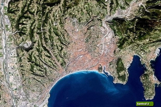 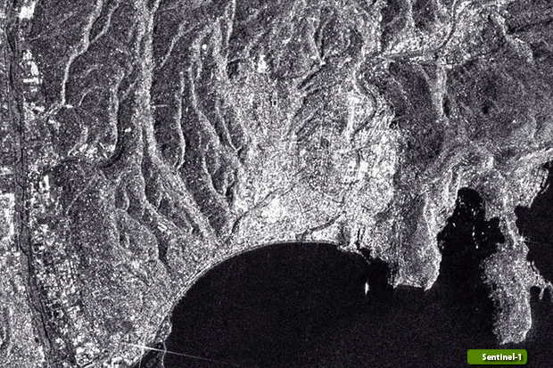 View Sentinel-1 high resolution image (JPG 841 KB) View Sentinel-2 high resolution image (JPG 796 KB)
|
|||||||||||||||||||