 Mosul, Iraq
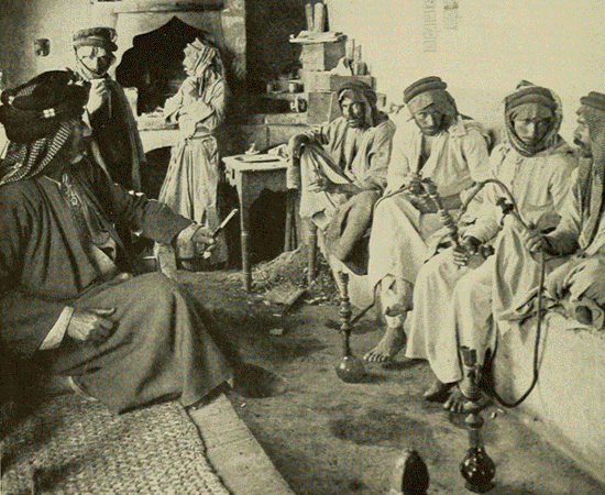
Mosul is a city in northern Iraq. Since October 2016 it has been the site of a military operation led by the Iraqi Government, under Haider al-Abadi, in an effort to dislodge and defeat militant forces. The city has been under the control of the Islamic State of Iraq and the Levant since June 2014, and no westerner has entered the city until the latest initiative. The Battle of Mosul, a military offensive to retake the city begun in October 2016, is the largest deployment of Iraqi forces since the 2003 invasion by U.S. and coalition forces. Located some 400 km north of Baghdad, the city stands on the west bank of the Tigris, opposite the ancient Assyrian city of Nineveh on the east bank. The metropolitan area has grown to encompass substantial areas on both the "Left Bank" (east side) and the "Right Bank" (west side), as the two banks are described by the locals compared to the flow direction of Tigris. At the start of the 21st century, Mosul and its surroundings had an ethnically and religiously diverse population; the majority of Mosul's population were Arabs, with Assyrians, Armenians, Turkmens, Kurds, Yazidis, Shabakis, Mandaeans, Kawliya, Circassians in addition to other, smaller ethnic minorities. In religious terms, mainstream Sunni Islam was the largest religion, but with a significant number of followers of the Salafi movement and Christianity (the latter followed by the Assyrians and Armenians), as well as Shia Islam, Sufism, Yazidism, Shabakism, Yarsanism and Mandaeism. The city's population grew rapidly around the turn of the millennium and by 2004 was estimated to be 1,846,500. An estimated half million people fled Mosul in the second half of 2014 when the IS fought with government forces for control of the city. While some residents returned, more fled in 2015 as fighting and violence increased, and US bombings pounded the city. On 17 November 2016, ISIS attacked the city of Mosul, ultimately killing seven civilians, two soldiers, and wounding 35 others. Historically, important products of the area include Mosul marble and oil. The city of Mosul is home to the University of Mosul and its renowned Medical College, which together was one of the largest educational and research centres in Iraq and the Middle East. The University has since been closed. The Islamic State's leadership in Mosul has kept the Medical College open but it is reported to be barely functional. Until 2014, the city, together with the nearby Nineveh plains, was one of the historic centers for the Assyrians and their churches; the Assyrian Church of the East; its offshoot, the Chaldean Catholic Church; and the Syriac Orthodox Church, containing the tombs of several Old Testament prophets such as Jonah, which was destroyed by the Islamic State occupation army in July 2014. More information is available on Wikipedia
This week our tour around the world stops over the city of Mosul. Mosul or Al Mawsil is a city in northern Iraq, capital of Ninawá Governorate, on the River Tigris. The city is linked by rail to other important towns in the country, and is connected to Turkey by road. Mosul is an important trade and market centre for the surrounding region, which is predominantly agricultural, producing cereals, fruit, and livestock; there are also rich oilfields in the area. Industries in Mosul include oil refineries, cement factories, textile mills, motor vehicle engineering, sugar beet refineries, and tanneries. Mosul has its own university and technical institute. Across the River Tigris are the ruins of Nineveh, capital of the ancient kingdom of Assyria. The remains of Hatra, a fortress of the Parthian empire and designated a World Heritage Site in 1985, are nearby. In these images acquired from the Landsat 5/8 satellites, we aim to show in this time window of 29 years (before - after) the large development that the city has experienced since 1987. The major development of new buildings along the north bank of the River Tigris can be seen. Another aim of these images is to promote the opportunity to download Landsat data through the ESA portals, where images captured every day are made available in near real time to the users and the scientific community. Landsat full resolution data products are freely available for immediate download at: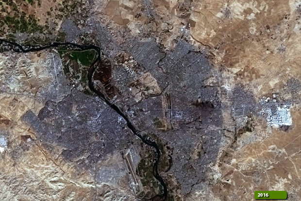 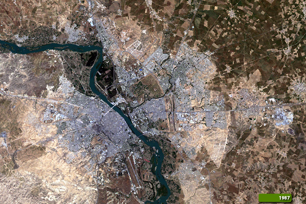 View Landsat 5 TM high resolution image (JPG 2.5 MB) View Landsat 8 OLI high resolution image (JPG 1.9 MB)
|
|||||||||||||||||||||