 Huelva Province, Spain
Huelva is a province of southern Spain, in the western part of the autonomous community of Andalusia. It is bordered by Portugal, the provinces of Badajoz, Seville, and Cádiz, and the Atlantic Ocean. Its capital is Huelva. Its area is 10,148 km2. Its population is 483,792 (2005), of whom about 30% live in the capital, and its population density is 47.67/km2. It contains 79 municipalities. The economy is based on agriculture and mining. The famous Rio Tinto mines have been worked since before 1000 BC, and were the major source of copper for the Roman Empire. As an indication of the scope of ancient mining, sixteen million tons of Roman slag have been identified at the Roman mines. British companies resumed large-scale mining in 1873; the district is the namesake of the Rio Tinto Group. The province contains Palos de la Frontera, and Moguer, where Christopher Columbus sailed out of on his first voyage in 1492, and shares the Parque Nacional de Donana. More information is available on Wikipedia

Today we feature the Huelva province in southern Spain. Located in the Andalusia Region, Huelva province is a provincia based on agriculture and mining. These images acquired by the Landsat 5 and 8 satellites have a temporal window of acquisition (before / after) of 30 years, and aim to show changes to the fields used for agricultural production. In the images acquired in 2014 we can see a large area (dark green) on the right side of the image used for strawberry production, while the white/light brown area is used for mining. The province contains Palos de la Frontera, and Moguer, which are located on the left side of the images along the Rio Tinto, and it was from this location that Christopher Columbus sailed out of on his first voyage in 1492. The National Park of Donana, a nature reserve and wetlands area, is located in the lower part of the images along the coast. Another aim of these images is to promote the opportunity to download Landsat data through the ESA portals, where images captured every day are made available in near real time to the users and the scientific community. Landsat full resolution data products are freely available for immediate download at: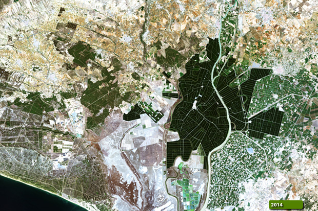  View Landsat 5 TM high resolution image (JPG 2.1 MB) View Landsat 8 OLI high resolution image (JPG 2.2 MB)
|
|||||||||||||||||||||