 Helsinki, Finland
Helsinki is the capital and largest city of Finland. It is in the region of Uusimaa, in southern Finland, on the shore of the Gulf of Finland. Helsinki has a population of 629,512, an urban population of 1,214,210, and a metropolitan population of over 1.4 million, making it the most populous municipality and urban area in Finland. Helsinki is located some 80 kilometres north of Tallinn, Estonia, 400 km east of Stockholm, Sweden, and 388 km west of Saint Petersburg, Russia. Helsinki has close historical connections with these three cities. The Helsinki metropolitan area includes the urban core of Helsinki, Espoo, Vantaa, Kauniainen, and surrounding commuter towns. It is the world's northernmost metro area of over one million people, and the city is the northernmost capital of an EU member state. The Helsinki metropolitan area is the fourth largest metropolitan area in the Nordic countries, the City of Helsinki being the third largest after Stockholm and Oslo. Helsinki is Finland's major political, educational, financial, cultural, and research centre as well as one of northern Europe's major cities. Approximately 75% of foreign companies operating in Finland have settled in the Helsinki region. The nearby municipality of Vantaa is the location of Helsinki Airport, with frequent service to various destinations in Europe and Asia. In 2009, Helsinki was chosen to be the World Design Capital for 2012 by the International Council of Societies of Industrial Design, narrowly beating Eindhoven for the title. The city was the venue for the 1952 Summer Olympics and the 52nd Eurovision Song Contest 2007. In 2011, the Monocle magazine ranked Helsinki the most liveable city in the world in its "Liveable Cities Index 2011". In the Economist Intelligence Unit's August 2015 Liveability survey, assessing the best and worst cities to live in globally, Helsinki placed among the world's top ten cities. More information is available on Wikipedia
This week our Landsat 5 and 8 imagery tour of the major cities in Europe, stops over Helsinki, the capital and chief seaport of Finland. The city is located in Etelä Province in southern Finland, on a small peninsula extending into the Gulf of Finland. Small islands fringe the peninsula, and the entrance to Helsinki harbour is protected by the fortifications of Suomenlinna (Swedish, Sveaborg), covering seven of the islands. Helsinki is the cultural, commercial, and political centre of Finland. The purpose of this image comparison, using images acquired in a time window of twenty-seven years, is to show the urban differences in and around the city. The comparison clearly shows large development to the city, especially in the south west part and near the airport, which was renovated during the intervening years with new airstrips. Another aim of these images is to promote the opportunity to download Landsat data through the ESA portals, where images captured every day are made available in near real time to the users and the scientific community. Landsat full resolution data products are freely available for immediate download at: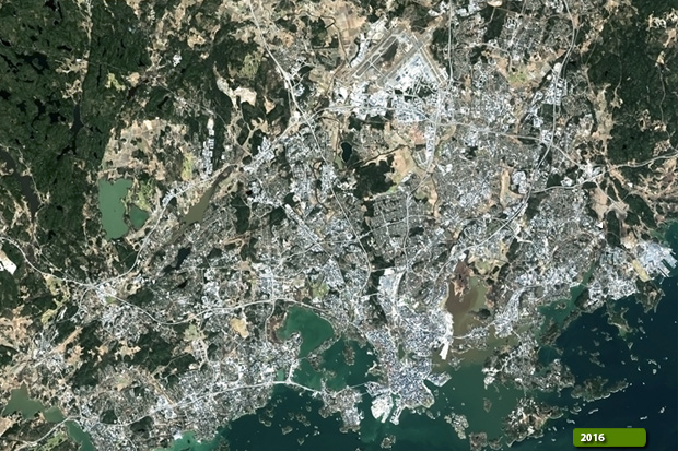 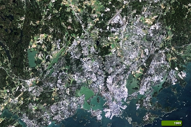 View Landsat 5 TM high resolution image (JPG 3.1 MB) View Landsat 8 OLI high resolution image (JPG 2.5 MB)
|
|||||||||||||||||||||