 Hamburg, Germany
Hamburg is the second largest city in Germany and the eighth largest city in the European Union. It is also the thirteenth largest German state. Its population is over 1.7 million people, and the Hamburg Metropolitan Region (including parts of the neighbouring Federal States of Lower Saxony and Schleswig-Holstein) has more than 5 million inhabitants. The city is situated on the river Elbe. The official name reflects its history as a member of the medieval Hanseatic League, as a free imperial city of the Holy Roman Empire, a city-state, and one of the 16 states of Germany. Before the 1871 Unification of Germany, it was a fully sovereign state. Prior to the constitutional changes in 1919, the stringent civic republic was ruled by a class of hereditary grand burghers or Hanseaten. Hamburg is a transport hub and is an affluent city in Europe. It has become a media and industrial centre, with plants and facilities belonging to Airbus, Blohm + Voss and Aurubis. The radio and television broadcaster Norddeutscher Rundfunk and publishers such as Gruner + Jahr and Spiegel-Verlag are pillars of the important media industry in Hamburg. Hamburg has been an important financial centre for centuries, and is the seat of the world's second oldest bank, Berenberg Bank. The city is a notable tourist destination for both domestic and overseas visitors; it ranked 16th in the world for livability in 2015. The Speicherstadt was declared a World Heritage Site by the UNESCO in July 2015. Hamburg is on the southern point of the Jutland Peninsula, between Continental Europe to the south and Scandinavia to the north, with the North Sea to the west and the Baltic Sea to the north-east. It is on the River Elbe at its confluence with the Alster and Bille. The city centre is around the Binnenalster ("Inner Alster") and Außenalster ("Outer Alster"), both formed by damming the River Alster to create lakes. The island of Neuwerk and two small neighbouring islands Scharhörn and Nigehörn, in the Hamburg Wadden Sea National Park, are also part of Hamburg. The neighbourhoods of Neuenfelde, Cranz, Francop and Finkenwerder are part of the Altes Land (old land) region, the largest contiguous fruit-producing region in Central Europe. Neugraben-Fischbek has Hamburg's highest elevation, the Hasselbrack at 116.2 metres AMSL. More information is available on Wikipedia

Our tour today stops over the city of Hamburg. Hamburg lies in north central Germany, on the Elbe and Alster rivers, near the North Sea. Its full name is the Free and Hanseatic City of Hamburg. Hamburg is the second busiest seaport in Europe and a major commercial, industrial, and cultural centre. Since 1937 the city has been coextensive with, and the capital of, the state of Hamburg (746 sq km/288 sq mi). This time window (before/after) of twenty-seven years, aims to show with the Landsat 5 and 8 satellites, the changes that the city has experienced from 1988 (Landsat 5) until 2015 (Landsat 8), in particular the urban area around the city and along the river. Another aim of these images is to promote the opportunity to download Landsat data through the ESA portals, where images captured every day are made available in near real time to the users and the scientific community. Landsat full resolution data products are freely available for immediate download at: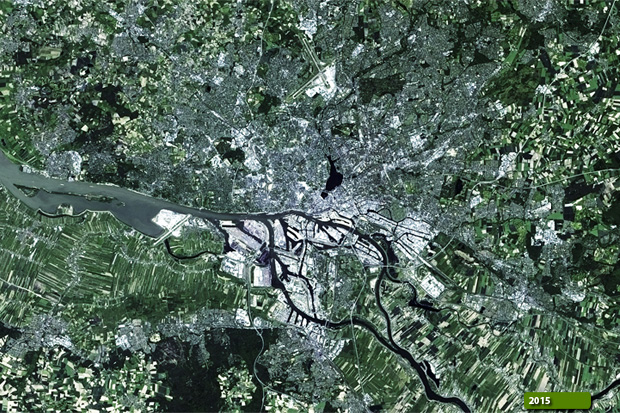 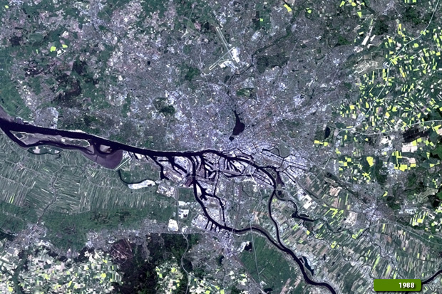 View Landsat 5 TM high resolution image (JPG 2 MB) View Landsat 8 OLI high resolution image (JPG 2 MB)
|
|||||||||||||||||||||