 Great Salt Lake, Utah
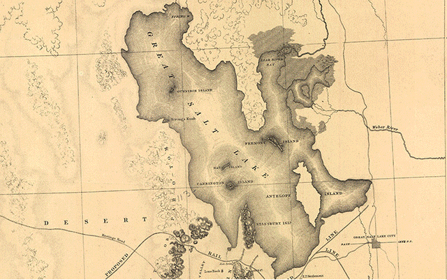
The Great Salt Lake, located in the northern part of the U.S. state of Utah, is the largest salt water lake in the Western Hemisphere, and the eighth-largest terminal lake in the world. In an average year the lake covers an area of around 4,400 km2, but the lake's size fluctuates substantially due to its shallowness. For instance, in 1963 it reached its lowest recorded size at 2,460 km2, but in 1988 the surface area was at the historic high of 8,500 km2. In terms of surface area, it is the largest lake in the United States that is not part of the Great Lakes region. The lake is the largest remnant of Lake Bonneville, a prehistoric pluvial lake that once covered much of western Utah. The three major tributaries to the lake, the Jordan, Weber, and Bear rivers together deposit around 1.1 million tons of minerals in the lake each year. As it is endorheic (has no outlet besides evaporation), it has very high salinity, far saltier than seawater, which makes swimming similar to floating, and its mineral content is steadily increasing. Its shallow, warm waters cause frequent, sometimes heavy lake-effect snows from late fall through spring. Although it has been called "America's Dead Sea", the lake provides habitat for millions of native birds, brine shrimp, shorebirds, and waterfowl, including the largest staging population of Wilson's phalarope in the world. The Great Salt Lake lends its name to Salt Lake City, originally named "Great Salt Lake City" by the president of The Church of Jesus Christ of Latter-day Saints (LDS Church) Brigham Young, who led a group of Mormon pioneers to the Salt Lake Valley southeast of the lake on 24 July 1847. The lake lies in parts of five counties: Box Elder, Davis, Tooele, Weber, and Salt Lake. Salt Lake City and its suburbs are located to the southeast and east of the lake, between the lake and the Wasatch Mountains, but land around the north and west shores are almost uninhabited. The Bonneville Salt Flats are to the west, and the Oquirrh and Stansbury Mountains rise to the south. Great Salt Lake is fed by three major rivers and several minor streams. The three major rivers are each fed directly or indirectly from the Uinta Mountain range in northeastern Utah. The Bear River starts on the north slope of the Uintas and flows north past Bear Lake, into which some of Bear River's waters have been diverted via a man-made canal into the lake, but later empty back into the river by means of the Bear Lake Outlet. The river then turns south in southern Idaho and eventually flows into the northeast arm of the Great Salt Lake. The Weber River also starts on the north slope of the Uinta Mountains and flows into the east edge of the lake. The Jordan River does not receive its water directly from the Uintas, rather it flows from freshwater Utah Lake, which itself is fed primarily by the Provo River; the Provo River does originate in the Uintas, a few miles from the Weber and Bear. The Jordan flows from the north part of Utah Lake into the southeast corner of the Great Salt Lake. More information is available on Wikipedia
We continue our tour around the world in 2017 and today we stop over the Great Salt Lake. The lake is irregular in shape and is about 121km long from north to south and 48 to 80km wide. The average depth of the lake is about 6m, but great seasonal variations occur. The lake is deepest in the spring, when it is fed by the melting snow from the nearby Wasatch Mountains to the east. Great Salt Lake occupies a portion of what was, in Pleistocene times, the bed of the great Bonneville Lake. The present lake has no outlets and loses water naturally only by evaporation, which concentrates the dissolved salts carried into the lake by its tributaries and causes its salinity. The salinity of Great Salt Lake, normally about 23 parts per 1,000, decreases when its area increases. The chief constituent of the dissolved salts is sodium chloride, which is recovered in commercial quantities. The lake has been estimated to contain more than 5 million tonnes of sodium chloride in solution. A few species of marine life have been found, including a brine shrimp variety. In this latest Landsat comparison we aim to show in a time window of 17 years (before - after) how the Great Salt Lake has changed. In these Landsat 7 and 8 images, in fact, the lake is full in June 2000 and in a drought in May 2017, particularly in the area of the promontory peninsula. Another aim of these images is to promote the opportunity to download Landsat data through the ESA portals, where images captured every day are made available in near real time to the users and the scientific community. Landsat full resolution data products are freely available for immediate download at: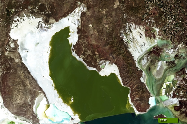 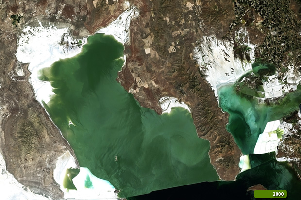 View Landsat 7 ETM high resolution image (JPG 8.9 MB) View Landsat 8 OLI high resolution image (JPG 8.7 MB)
|
|||||||||||||||||||||