 Gothenburg, Sweden
Gothenburg is the second-largest city in Sweden and the fifth-largest in the Nordic countries. Situated by the Kattegat, on the west coast of Sweden, the city proper has a population of 543,005, with 549,839 in the urban area and 973,261 inhabitants in the metropolitan area. Gothenburg was founded by royal charter in 1621 by King Gustavus Adolphus. At the mouth of the Göta älv, the Port of Gothenburg is the largest port in the Nordic countries. Gothenburg is home to many students, as the city includes both the University of Gothenburg and Chalmers University of Technology. Volvo was founded in Gothenburg in 1927. The city is a major center for sports and home to the IFK Göteborg, BK Häcken, GAIS, and Örgryte IS association football teams, the handball team Redbergslids IK, as well as the Frölunda HC ice hockey team. Gothenburg is served by Göteborg Landvetter Airport, located 30 km southeast of the city centre. The smaller Göteborg City Airport, located 15 km from the city center, was closed to regular airline traffic in 2015. The city hosts some of the largest annual events in Scandinavia. The Gothenburg Film Festival, held in January since 1979, is the leading Scandinavian film festival with over 155,000 visitors each year. In summer, a wide variety of music festivals are held in the city, such as Way Out West and Metaltown. The annual Gothia Cup, is the world's largest football tournament with regards to the number of participants: in 2011, a total of 35,200 players from 1,567 teams and 72 nations participated. More information is available on Wikipedia

Our tour today stops over the city of Gothenburg (also known as Göteborg), which is located in south-west Sweden, capital of Göteborg och Bohus County, at the mouth of the Göta River. With a generally ice-free harbour, Gothenburg is the principal port and second-largest city in Sweden. Industries include car manufacturing, the production of bearings, ship maintenance and shipbuilding, brewing and distilling, cabinet-making, timber processing, and the processing of textiles, leather, and tobacco. The city is connected with the interior by rail and by the Göta Canal, opened in 1832. The airport at Landvetter, about 20 km east of the city, serves both domestic and international airlines.
With the comparison of these Landsat 5 and 8 satellite images acquired with a time window (before/after) of twenty-seven years, we aim to show the urban changes that the city has experienced from 1988 (Landsat 5) until 2015 (Landsat 8). In this comparison we can see that the city and suburbs have undergone a large urban development. Landsat full resolution data products are freely available for immediate download at: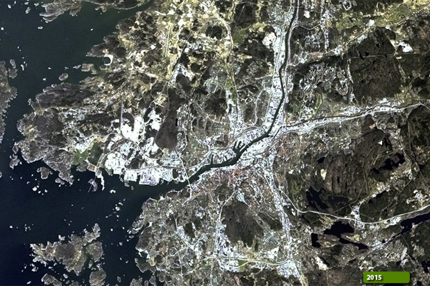 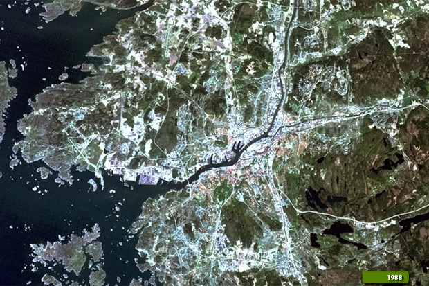 View Landsat 5 TM high resolution image (JPG 712 KB) View Landsat 8 OLI high resolution image (JPG 800 KB)
|
|||||||||||||||||||||