 Edinburgh, Scotland
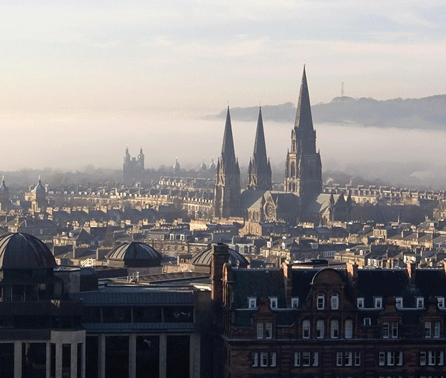
Edinburgh is the capital city of Scotland, located in Lothian on the southern shore of the Firth of Forth. It is the second most populous city in Scotland and the seventh most populous in the United Kingdom. The most recent official population estimates are 464,990 for the city of Edinburgh itself and 492,680 for the local authority area. Edinburgh lies at the heart of the Edinburgh & South East Scotland City region with a population in 2014 of 1,339,380. Recognised as the capital of Scotland since at least the 15th century, Edinburgh is home to the Scottish Parliament and the seat of the monarchy in Scotland. The city is also the annual venue of the General Assembly of the Church of Scotland and home to national institutions such as the National Museum of Scotland, the National Library of Scotland and the Scottish National Gallery. It is the largest financial centre in the UK after London. Historically part of Midlothian, the city has long been known as a centre of education, particularly in the fields of medicine, Scots law, literature, the sciences and engineering. The University of Edinburgh, founded in 1582 and now one of four in the city, was placed 17th in the QS World University Rankings in 2013 and 2014. The city is also famous for the Edinburgh International Festival and the Fringe, the latter being the largest annual international arts festival in the world. The city's historical and cultural attractions have made it the second most popular tourist destination in the United Kingdom after London, attracting over one million overseas visitors each year. Historic sites in Edinburgh include Edinburgh Castle, Holyrood Palace, the churches of St. Giles, Greyfriars and the Canongate, and the extensive Georgian New Town, built in the 18th century. Edinburgh's Old Town and New Town together are listed as a UNESCO World Heritage Site, which has been managed by Edinburgh World Heritage since 1999. Situated in Scotland's Central Belt, Edinburgh lies on the southern shore of the Firth of Forth. The city centre is 4 km southwest of the shoreline of Leith and 42 km inland, as the crow flies, from the east coast of Scotland and the North Sea at Dunbar. While the early burgh grew up in close proximity to the prominent Castle Rock, the modern city is often said to be built on seven hills, namely Calton Hill, Corstorphine Hill, Craiglockhart Hill, Braid Hill, Blackford Hill, Arthur's Seat and the Castle Rock, giving rise to allusions to the seven hills of Rome. Occupying a narrow gap between the Firth of Forth to the north and the Pentland Hills and their outrunners to the south, the city sprawls over a landscape which is the product of early volcanic activity and later periods of intensive glaciation. Igneous activity between 350 and 400 million years ago, coupled with faulting, led to the creation of tough basalt volcanic plugs, which predominate over much of the area. One such example is the Castle Rock which forced the advancing icesheet to divide, sheltering the softer rock and forming a 1.6 km tail of material to the east, thus creating a distinctive crag and tail formation. Glacial erosion on the north side of the crag gouged a deep valley later filled by the now drained Nor Loch. These features, along with another hollow on the south side of the rock, formed an ideal natural strongpoint upon which Edinburgh Castle was built. Similarly, Arthur's Seat is the remains of a volcano dating from the Carboniferous period, which was eroded by a glacier moving west to east during the ice age. Erosive action such as plucking and abrasion exposed the rocky crags to the west before leaving a tail of deposited glacial material swept to the east. This process formed the distinctive Salisbury Crags, a series of teschenite cliffs between Arthur's Seat and the location of the early burgh. The residential areas of Marchmont and Bruntsfield are built along a series of drumlin ridges south of the city centre, which were deposited as the glacier receded. Other prominent landforms such as Calton Hill and Corstorphine Hill are similarly products of glacial erosion. The Braid Hills and Blackford Hill are a series of small summits to the south west of the city commanding expansive views looking northwards over the urban area to the Forth. More information is available on Wikipedia
Our tour over the major European cities continues this year and the first of 2016 features the city of Edinburgh. Capital city of Scotland, on the southern shore of the Firth of Forth. Edinburgh is the second most populous city in Scotland after Glasgow, and is Scotland's administrative, cultural, educational, and service-industry hub. Its heritage and architectural variety also make it one of the main tourist centres of Great Britain. Edinburgh is the seat of government in Scotland. The 129-seat Scottish Parliament was temporarily based in the Church of Scotland's General Assembly Building on the Mound in Edinburgh for five years. A new purpose-built complex, located on a large site on the Royal Mile near to Holyrood Palace, opened in September 2004. Of Scotland's 72 Members of Parliament, 6 are returned to Westminster from Edinburgh constituencies (Edinburgh Central, Edinburgh East and Musselburgh, Edinburgh North and Leith, Edinburgh Pentlands, Edinburgh South, and Edinburgh West). Edinburgh is represented in the European Parliament within the Lothians constituency (one of eight Scottish seats). These images acquired by the Landsat 5 and 8 satellites have a time window of acquisition (before / after) of twenty-six years, and aim to show the urban difference from 1989 until today. In the comparison, the users are able to see the little difference of urban development around the suburb of the old city and along the coast (especially in the harbour area) and in the are around the airport. Another aim of these images is to promote the opportunity to download Landsat data through the ESA portals, where images captured every day are made available in near real time to the users and the scientific community. Landsat full resolution data products are freely available for immediate download at: 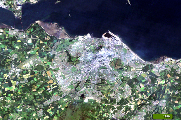 View Landsat 5 TM high resolution image (JPG 806 KB) View Landsat 8 OLI high resolution image (JPG 1.2 MB)
|
|||||||||||||||||||||