 Calbuco Volcano, Chile
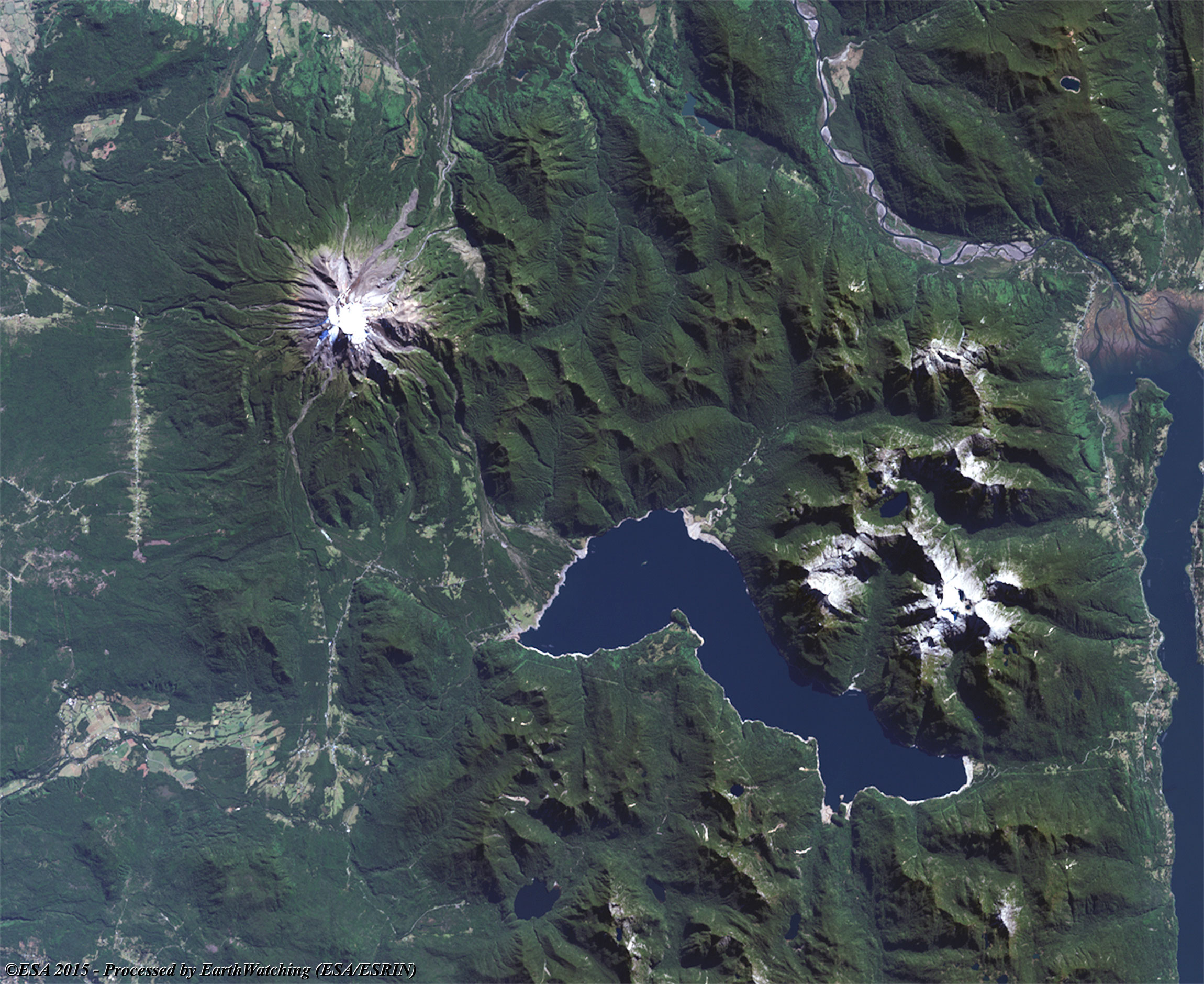
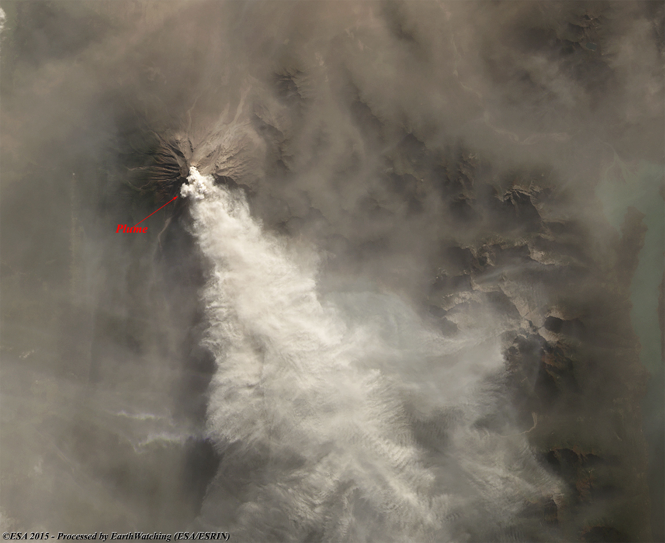
Calbuco is a stratovolcano, also known as a composite volcano, a conical volcano built up by many layers (strata) of hardened lava, tephra, pumice, and volcanic ash. Unlike shield volcanoes, stratovolcanoes are characterised by a steep profile and periodic explosive eruptions and effusive eruptions, although some have collapsed craters called calderas. The lava flowing from stratovolcanoes typically cools and hardens before spreading far due to high viscosity. The magma forming this lava is often felsic, having high-to-intermediate levels of silica (as in rhyolite, dacite, or andesite), with lesser amounts of less-viscous mafic magma. Extensive felsic lava flows are uncommon, but have travelled as far as 15 km. Stratovolcanoes are sometimes called "composite volcanoes" because of their composite layered structure built up from sequential outpourings of eruptive materials. They are among the most common types of volcanoes, in contrast to the less common shield volcanoes. Two famous stratovolcanoes are Krakatoa, best known for its catastrophic eruption in 1883 and Vesuvius, famous for its destruction of the towns Pompeii and Herculaneum in 79 AD. Both eruptions claimed thousands of lives. The volcano is located southeast of Llanquihue Lake and northwest of Chapo Lake, in the Los Lagos Region of Chile. The volcano and the surrounding area are protected within Llanquihue National Reserve. It is a very explosive andesite volcano whose lava usually contains 55 to 60% silicon dioxide (SiO2). It underwent edifice collapse in the late Pleistocene, producing a volcanic debris avalanche that reached the lake. The most recent eruption was on 22 April 2015, the first since 1972. Calbuco has had at least 10 eruptions since 1837. One of the largest historical eruptions in southern Chile took place there in 1893–1894. Violent eruptions ejected 30-cm bombs to distances of eight kilometres from the crater, accompanied by voluminous hot lahars. Strong explosions occurred in April 1917, and a lava dome formed in the crater accompanied by hot lahars. Another short explosive eruption in January 1929 also included an apparent pyroclastic flow and a lava flow. A major eruption of Calbuco in 1961 sent ash columns 12–15 km high and produced plumes that dispersed mainly to the south east and two lava flows were also emitted. There was a minor, four-hour eruption on 26 August 1972. Strong fumarolic emission from the main crater was observed on 12 August 1996. Calbuco erupted on 22 April 2015, for the first time in four decades. The eruption lasted 90 minutes and sent a plume of volcanic ash 10 km into the sky. A flow of lava was reported into Chapo Lake on the same day. The eruption caused airline flight cancellations to Chile as well as Argentina and Uruguay. Authorities evacuated 4000 people from a zone with a 20 km radius from the volcano. The Chilean administration had faced two major catastrophes in the previous months; a wildfire in Valparaíso and a flood in northern towns. More information is available on Wikipedia
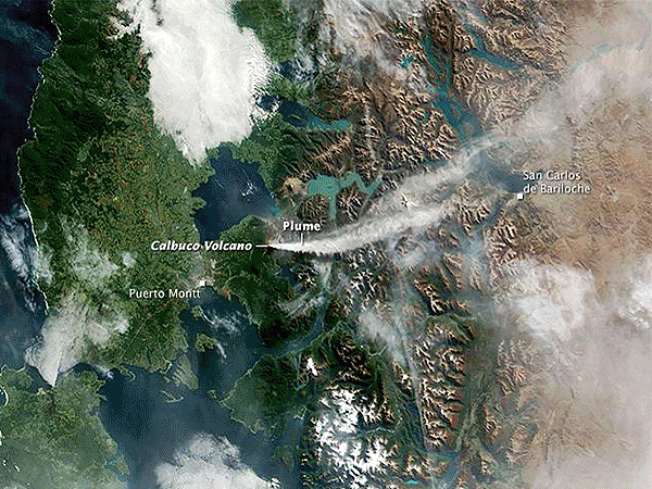
Today we feature Calbuco Volcano in Chile. The volcano, on 22 April 2015 started its latest period of activity with eruptions, and the emission of gas, ash, and lava into the air. These images processed by by the Landsat 8 satellite acquired in March and April, show the volcano's activity during this time window. In the comparison the large plume is clearly visible emerging from the crater of the volcano. Another aim of these images is to promote the opportunity to download Landsat data through the ESA portals, where images captured every day are made available in near real time to the users and the scientific community. Landsat full resolution data products are freely available for immediate download at: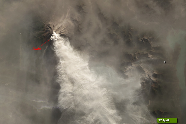 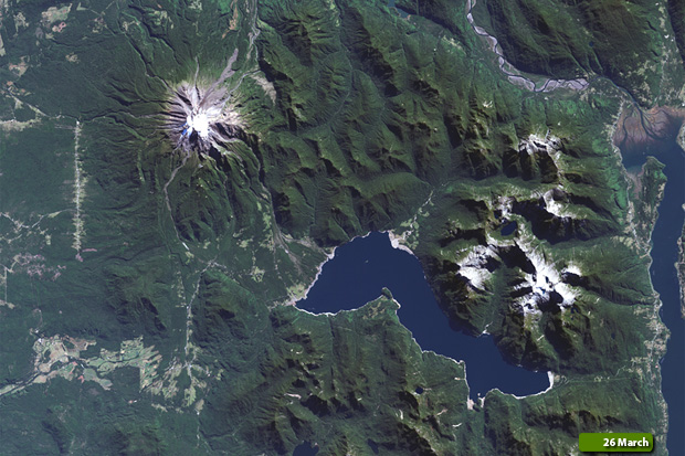 View Landsat 8 OLI high resolution image - Before eruption (JPG 856 KB) View Landsat 8 OLI high resolution image - During eruption (JPG 503 KB)
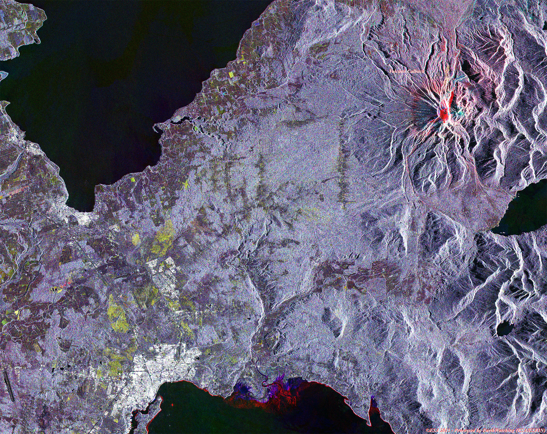
These images acquired by the Sentinel-1 satellite from March to May, show Calbuco Volcano during the eruption phase starting from April. Using this merge of images before and during the eruption it is possible to see in red the area where the lava comes out of the volcano. Sentinel-1 is a space mission from ESA of the Copernicus Programme, consisting of a constellation of two satellites. The payload of Sentinel-1 is a Synthetic Aperture Radar in C-band that provides continuous imagery (day, night and all weather). This merge image, aims to also demonstrate the future monitoring of Earth with the Sentinel satellites. More information is available on Wikipedia 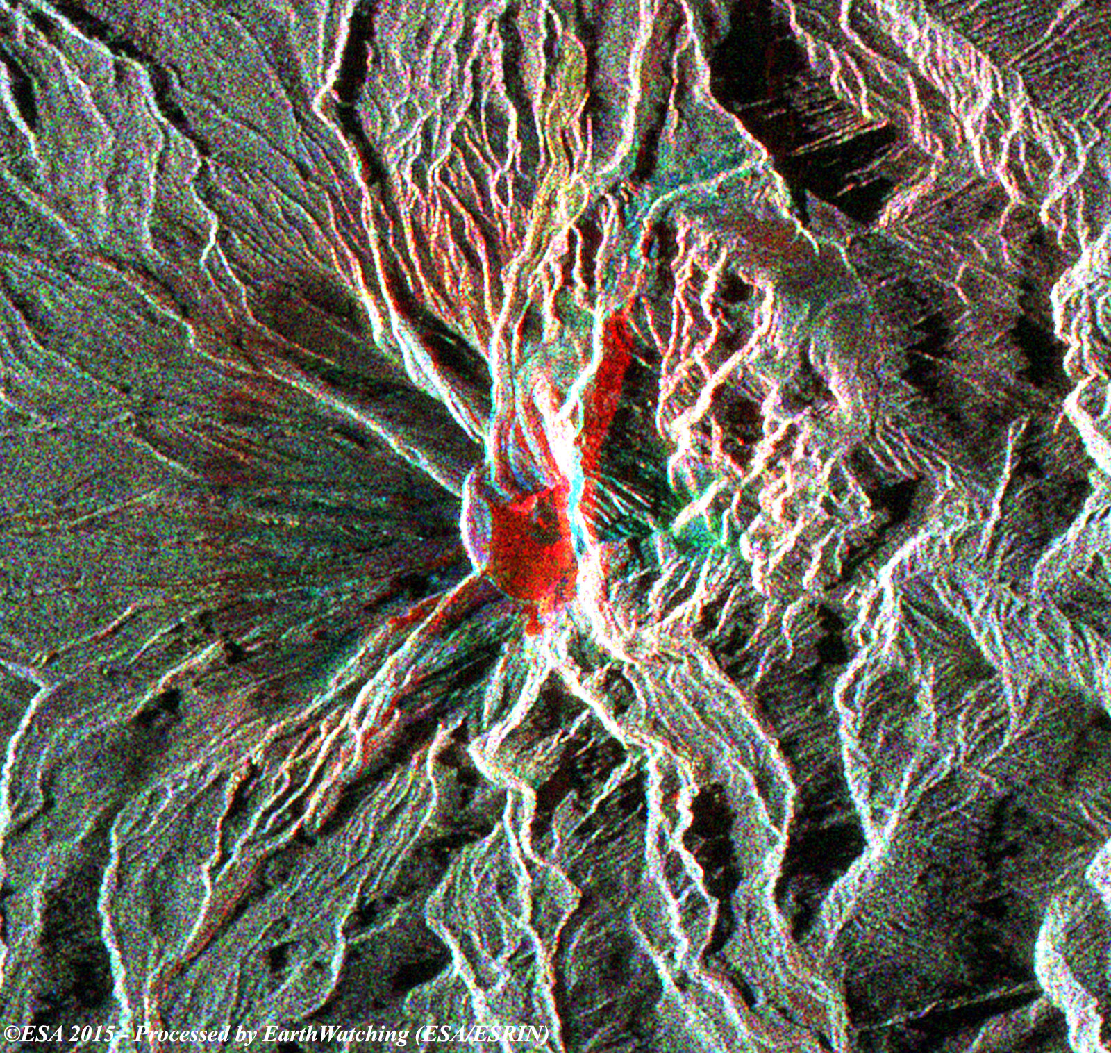 View Sentinel-1 high resolution merge (JPG 1.1 MB) View Sentinel-1 merge large area (JPG 3.5 MB)
|
|||||||||||||||||||||||||||||||||||||||