 Antalya, Turkey
Antalya is the eighth most populous city in Turkey and the capital of its eponymous province. Located on Anatolia's flourishing southwest coast bordered by the Taurus Mountains, Antalya is the largest Turkish city on the Mediterranean coast with over one million people in its metropolitan area. The city that is now Antalya was first settled around 200 BC by the Attalid dynasty of Pergamon, which was soon subdued by the Romans. Roman rule saw Antalya thrive, including the construction of several new monuments, such as Hadrian's Gate, and the proliferation of neighbouring cities. The city has changed hands several times, including to the Byzantine Empire in 1207 and an expanding Ottoman Empire in 1391. Ottoman rule brought relative peace and stability for the next five-hundred years. The city was transferred to Italian suzerainty in the aftermath of World War I, but was recaptured by a newly independent Turkey in the War of Independence. Antalya is Turkey's biggest international sea resort, located on the Turkish Riviera. Large-scale development and governmental funding has promoted tourism. A record 12.5 million tourists passed through the city in 2014. Antalya was the host city for the 2015 G-20 summit. Source and informations from Wikipedia

Our cities tour today resumes from the city and region of Antalya. Antalya is on the shores of the Mediterranean Sea and situated in the gulf bearing the same name, in the south of the Anatolia peninsula. The southern edge of Antalya gulf is open with the other three edges being surrounded by very steep and thickly wooded mountains which start almost from the sea and reach a considerable altitude in a short distance to the Mediterranean. Bey mountain group extends to the west of the Antaya gulf and Toros Mountain is located to the north and north east. These young mountains bear a limestone structure, being connected with the Alpine oregenesis system. Owing to this limestone structure these mountains are suitable for carstic formations. So, there are many small and large caves in numerous sites of the region. Some of them are open to visit today. This comparision of images made using the Landsat 5 and 8 satellites with the combination of bands in visible colour, have been acquired with a time window (before/after) of thirty-one years. They aim to show the changes that the city has experienced from 1984 (Landsat 5) until 2015 (Landsat 8), in particular along the coast, but is significative as the territory and the urban area have had a large development (see also the area of the airport and around it) during this time window. Another aim of these images is to promote the opportunity to download Landsat data through the ESA portals, where images captured every day are made available in near real time to the users and the scientific community. Landsat full resolution data products are freely available for immediate download at: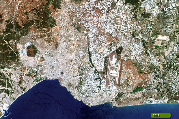 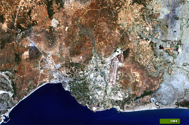 View Landsat 5 TM high resolution image (JPG 911 KB) View Landsat 8 OLI high resolution image (JPG 1 MB)
|
|||||||||||||||||||||